World Oceans: Satellites are Going to Track Garbage Drifting Across the Oceans
Key Takeaway
Satellites equipped with advanced algorithms and supercomputers are revolutionizing the way we track marine debris, providing crucial data to combat ocean pollution effectively.
Summary
- Marine pollution is a growing concern with 200 million tons of plastic estimated in our oceans.
- A team at the Institut de Ciencies del Mar at the University of Cadiz has demonstrated the potential of satellites to track oceanic debris.
- 300,000 images from the European Copernicus Sentinel-2 satellite were analyzed to identify debris.
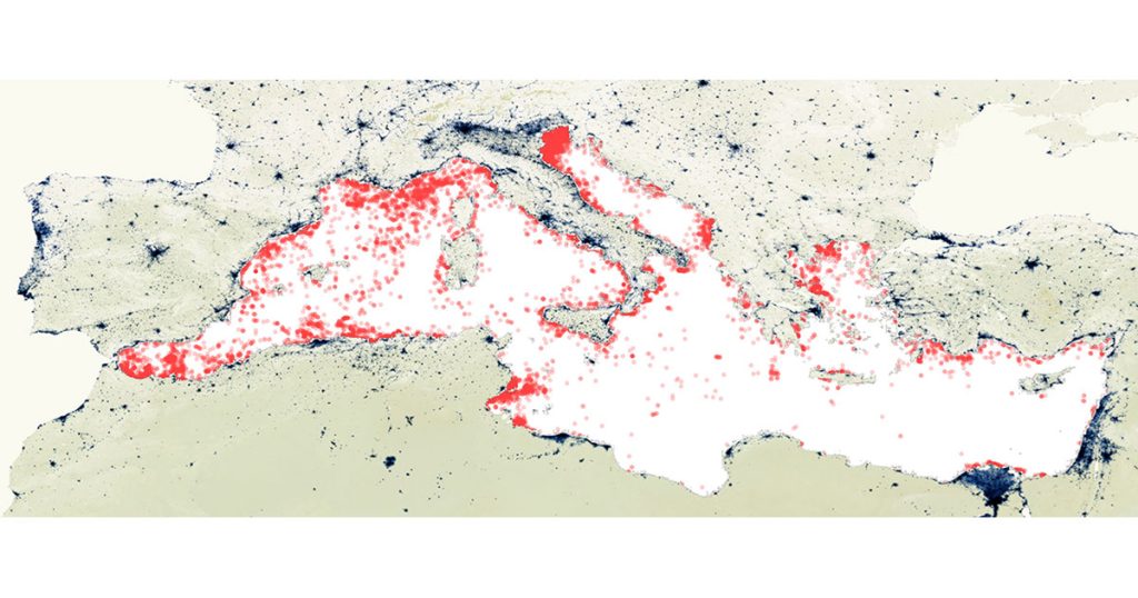
- The study focuses on the Mediterranean Sea, revealing the most polluted areas and main entry points of debris.
- Satellite-based monitoring can significantly enhance detection capabilities and model the impact of marine pollution on ecosystems and tourism.
- Geographical factors such as population density and rainfall influence the accumulation of marine litter.
- Satellite technology can also be used for other applications like oil spill detection, search and rescue operations, and monitoring lost ships.

Introduction
We are all too aware of the pollution on planet Earth. Increased amounts of plastic and garbage on the world’s beaches and debris littering the oceans have become an alarming issue. Traditionally, it was believed that satellites weren’t capable of tracking marine debris. However, a groundbreaking study challenges this notion.
The Study: Tracking Marine Debris with Satellites
A team led by the Institut de Ciencies del Mar at the University of Cadiz has unveiled the potential of satellites in tracking surface debris in the oceans. Utilizing supercomputers and advanced algorithms, they have shown that satellites can indeed be used to monitor marine litter.
Methodology
The study utilized data from the European Copernicus Sentinel-2 satellite, analyzing 300,000 images of the Mediterranean Sea. These images, taken every three days at a resolution of 10 meters, allowed for the identification of large concentrations of debris.
Key Findings
- The output from the study reveals the most polluted areas of the Mediterranean and the main entry points from the mainland.
- The results show that the amount of debris in the Mediterranean covers around 95 square kilometers.
The Scale of Marine Pollution
Upper estimates suggest there could be around 200 million tons of plastic in our oceans. Moreover, every day, it is believed another 8 million pieces of plastic make their way into the marine environment. This staggering amount of debris poses a significant threat to marine life and ecosystems.
Windrows: Accumulation of Debris
The images from the Sentinel-2 satellite identified large accumulations of debris known as windrows. These structures form as ocean currents and winds bring debris together, creating significant aggregations.
Table 1: Plastic Pollution Estimates
| Source | Estimate of Plastic (Tons) |
|---|---|
| Low Estimate | 50 million |
| Mid Estimate | 100 million |
| High Estimate | 200 million |
Implications of the Study
The research offers valuable insights into the scale and distribution of marine litter. While it does not solve the pollution issue directly, it enhances our understanding and provides a basis for future monitoring and mitigation efforts.
Population Density and Geography
One element of the study’s conclusion is that population density, geography, and rainfall patterns play a crucial role in the accumulation of marine litter. Dry, arid lands like deserts, which host cities, contribute much less to marine litter compared to temperate regions with higher rainfall.
Coastal Proximity
Interestingly, the majority of litter that originates from land masses seems to be confined to 15 kilometers from the coast and tends to return after a few days or months.
Future Applications of Satellite Technology
Satellite-based monitoring is deemed an essential element in the battle against ocean litter. The technology can also be applied to other areas such as:
- Detection of floating objects
- Monitoring oil spills
- Search and rescue operations
Recommendations for Future Satellites
The team proposes that future satellites should be equipped with specialized detectors to monitor debris. This enhancement could increase the ability to detect plastic in the open ocean by a factor of 20.
Table 2: Enhanced Detection Capabilities
| Current Capability | Enhanced Capability |
|---|---|
| 10% of ocean debris | 90% of ocean debris |
Impact on Tourism and Marine Ecosystems
Understanding the distribution and movement of marine debris can help in modeling its impact on tourism and marine ecosystems. Clean oceans are vital for the health of marine life and the economy of coastal regions that rely on tourism.
Conclusion
The use of satellites to track marine debris is a promising development in the fight against ocean pollution. With continued advancements in satellite technology and algorithms, we can enhance our ability to monitor, understand, and mitigate the effects of marine litter. This study marks a significant step towards cleaner oceans and a healthier planet.
