Tag

#spacetech

Browsing

How the U.S. Space Force Safeguards America’s Satellites

The U.S. Space Force (USSF) is the newest branch of the U.S. military, created in 2019 to protect American interests in space. It tracks satellites and debris, secures vital communications like GPS, defends against hostile actions using electronic and cyber tools, and develops future space defense technologies—all while working alongside civilian agencies such as NASA.

Summary

  • The USSF launched as a separate service in 2019
  • It safeguards U.S. satellites and other space assets
  • Teams monitor orbiting objects to prevent collisions
  • It runs and protects the GPS navigation system
  • Military communications rely on its satellite fleets
  • Defensive operations “blind and deafen” enemy satellites
  • Cyber units target threats to space systems on Earth
  • It shares tracking data with global partners
  • Budget has grown past NASA’s, fueling new projects
  • It avoids physical attacks that would create dangerous debris
  • Collaboration with NASA boosts both science and security
  • Training covers orbital mechanics and cyber warfare
  • Future plans include on-orbit servicing and advanced sensors
  • It faces challenges like space debris and unclear laws
  • Its motto is “Semper Supra”—Always Above

How the U.S. Space Force Safeguards America’s Satellites

The Origins of the Space Force

In December 2019, the U.S. stood up the Space Force as its sixth military branch. Leaders saw space as a critical domain for both security and national power. Before that, the Air Force managed space duties. Congress passed the Space Force act to make domain awareness and defense its sole mission (About Us).

Mission and Responsibilities

The USSF has four main roles. It operates military and navigation satellites. It tracks objects in orbit, like debris and other nations’ spacecraft. It secures critical communications channels. And it innovates new defenses, including cyber and electronic tools. Together, these keep U.S. systems running and safe.

Tracking Space Objects

Space Force teams use ground stations and space sensors to watch more than 27,000 objects in Earth orbit. They share data with the Joint Space Operations Center to predict and prevent collisions. This work protects active satellites and helps astronauts stay safe on missions.

Communications and Navigation

USSF manages satellite networks that carry military calls, data links, and missile warnings. It also keeps the GPS constellation healthy. Everyday devices—cars, planes, and phones—depend on those signals. Teams replace old satellites and fix jamming attempts so services stay reliable.

Space Operations: Defense and Offense

Space can be a silent battlefield. Instead of shooting at satellites, the Space Force uses electronic warfare to blind or deafen hostile systems. Cyber units on Earth target networks controlling enemy spacecraft. All tactics stay classified to protect U.S. methods and assets.

“There are a few different ways the Space Force carries out its mission,” said Space Insider. “One is simply watching and waiting, using both ground- and space-based systems to track objects in orbit.”
— Space Insider

Organization and Teams

The Space Force includes field commands focused on operations, systems, training, and acquisition. Each command has experts in satellites, cyber, and engineering who work together to meet mission goals.

Command Name Mission Focus
Space Operations Command Satellite control and domain awareness
Space Systems Command R&D, acquisition, and launch support
Space Training Command Education in orbital mechanics, cyber
Space Acquisition Building and testing new spacecraft

Training and Personnel

The USSF draws talent from the Air Force, Army, and civilian experts. Recruits learn at special schools—some at the Space Systems Command—covering orbital physics, satellite ops, and cyber warfare. Regular exercises simulate satellite threats and debris tracking so teams can respond fast and smart.

Budget and Growth

Since its creation, the Space Force budget has steadily risen—surpassing NASA’s alone some years—to fund satellites, ground stations, and research labs.

Year USSF Budget (USD) NASA Budget (USD)
2019 15 billion 22.6 billion
2020 18 billion 23 billion
2021 21 billion 24 billion
2022 24 billion 25 billion
2023 26 billion 25.5 billion

Collaboration with NASA

Though NASA focuses on science—like the Perseverance rover’s Mars mission—the agencies share tech and data. NASA builds rockets for exploration, while the Space Force adapts similar systems for defense. Working together saves money and boosts safety in space (NASA, Perseverance Rover).

Future Plans

Looking ahead, USSF will field new satellites with advanced sensors and test on-orbit servicing to fix or refuel aging spacecraft. It plans laser-based communications for faster data. Partnerships with allies through the Combined Space Operations Center aim to share tracking data. New units will watch space weather to guard against solar storms.

Challenges Ahead

Space is crowded, and debris grows every year. The Space Force must find better ways to clear and track junk. International laws for space conflict remain vague. Tech must evolve quickly to meet fast-moving threats in orbit.

Facts

  • The Space Force’s logo is the Delta, Globe, and Star motif.
  • Its motto, “Semper Supra,” means “Always Above.”
  • General John W. Raymond is its first Chief of Space Operations.
  • The Space Medal rewards exceptional service.
  • Uniforms feature unique grey digital patterns.

References

QuantX Labs’ TEMPO Mission: First Optical Frequency Comb Launch to Orbit in 2025

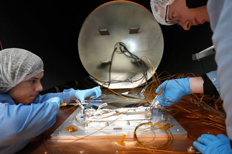
QuantX Labs is set to deploy its TEMPO optical atomic clock subsystem—an Optical Frequency Comb—into low Earth orbit late in 2025, backed by a $3.7 million grant from the Australian Space Agency’s Moon to Mars initiative. This first-ever spaceborne frequency comb will undergo rigorous environmental testing on Exotrail’s spacevan™, flown by SpaceX, paving the way for ultra‑precise space-based timing, navigation, and Earth observation systems that could one day rival GPS.

Summary

  • QuantX Labs, a leader in quantum sensor technologies, will launch a key component of its TEMPO atomic clock system into space aboard Exotrail’s spacevan™ on a SpaceX mission.
  • The project is supported by a $3.7 million grant from the Australian space Agency’s Moon to Mars initiative, demonstrating strong government backing for sovereign space capabilities.
  • The subsystem, known as an Optical Frequency Comb, extends beyond timing to deep‑space communications, navigation, positioning, and synchronized Earth observation.
  • This mission marks the first deployment of an optical frequency comb in orbit—an innovation that earned the Nobel Prize in Physics in 2005—but never before flown.
  • The comb has passed extensive environmental tests (temperature extremes, vacuum, vibration, radiation) to endure launch stresses and space conditions.
  • Exotrail’s spacevan™ made its debut flight on SpaceX Transporter‑9 in November 2023, proving its in‑orbit mobility service capability.
  • QuantX Labs’ Managing Director, Professor Andre Luiten, calls this launch a “breakthrough” achieved faster and at lower cost than traditional atomic clock missions.
  • Dr. Sebastian Ng, QuantX’s PNT Program Lead, notes that the comb’s success will guide integration of the full TEMPO clock for future missions.
  • A QuantX team will travel to Exotrail’s Paris HQ this month for final integration tests before shipment to the U.S. launch site.
  • The one‑year mission will be Exotrail’s second spacevan™ flight following the successful 2023 demo; ongoing operations bolster confidence in the service.

QuantX Labs’ TEMPO Mission First Optical Frequency Comb Launch to Orbit in 2025

Introduction

QuantX Labs, based in Adelaide, Australia, is at the forefront of precision timing and quantum sensing. In partnership with French in‑space logistics firm Exotrail, QuantX is preparing to launch the Optical Frequency Comb—a core part of its TEMPO optical atomic clock—into low Earth orbit late in 2025 aboard Exotrail’s spacevan™ on a SpaceX Falcon 9 rideshare QuantX Labs – Quantifying The Unknown. The project is underwritten by a $3.7 million grant from the Australian Space Agency’s Moon to Mars initiative, reflecting Australia’s commitment to sovereign space‑based navigation and timing.

Background on Optical Frequency Combs

Optical Frequency Combs were first pioneered around 2000 and garnered the Nobel Prize in Physics in 2005 for their role in precision spectroscopy and timing QuantX Labs – Quantifying The Unknown. These “combs” produce a spectrum of discrete, equally spaced optical frequencies that serve as an ultra‑stable ruler for measuring time and frequency. On the ground, combs have revolutionized telecommunications and metrology. Flying one in space opens new frontiers in deep‑space communications, navigation, and synchronized Earth observation.

“This launch represents not only a breakthrough for our TEMPO technology but also the culmination of countless hours of hard work by our engineers and physicists. We have managed to deliver this outcome in much less time and at much less cost than is traditional,” said Professor Andre Luiten, Managing Director of QuantX Labs QuantX Labs – Quantifying The Unknown.

TEMPO Atomic Clock System

The TEMPO (Time‑based Precision Oscillator) system integrates the Optical Frequency Comb with cutting‑edge lasers, atomic references, and control electronics. Together, they form an optical atomic clock capable of 10⁻¹⁸ timing precision—orders of magnitude better than current space clocks Orbital Today. TEMPO’s modular design allows the comb to serve as a subsystem ahead of the full payload, reducing risk and enabling iterative technology maturation.

Environmental Testing and Validation

QuantX’s Optical Frequency Comb has successfully endured a battery of harsh environmental tests designed to simulate launch and on‑orbit conditions:

Test Type Simulated Condition Status
Temperature Extremes –40 °C to +85 °C cycling Passed
High Vacuum 10⁻⁶ Torr level Passed
Vibration & Shock Random and sine vibration profiles Passed
Radiation Exposure Total ionizing dose > 10 kRad(Si) Passed

Table 1: Environmental Test Results for Temporal Stability

Mission Timeline and Partnerships

Milestone Date Partner/Location
Grant Awarded April 2025 Australian Space Agency
Integration Testing Begins April 2025 Exotrail HQ, Paris, France
Shipment to Launch Site Late 2025 U.S. West Coast
Orbital Launch December 2025 (TBD) SpaceX Falcon 9
Mission Operations Period 1 year LEO

Table 2: Key Mission Timeline for the Optical Frequency Comb Launch QuantX Labs – Quantifying The Unknown

Exotrail’s spacevan™ made its maiden flight on SpaceX’s Transporter‑9 mission in November 2023, demonstrating its in‑orbit transfer capabilities before handling the QuantX payload exotrail.com. This upcoming flight will be the spacevan’s second orbital mission, leveraging that flight heritage to ensure mission success

Future Applications and Impact

Beyond demonstrating an Australian sovereign timing capability, this mission lays groundwork for next‑generation navigation, deep‑space networks, and Earth observation. By flying optical clocks in space, QuantX aims to supplement or even replace existing GPS and GNSS systems, offering enhanced accuracy and resilience against signal interference Orbital Today. Dr. Sebastian Ng, QuantX’s PNT Program Lead, notes that insights from the frequency comb deployment will inform the development of the full TEMPO payload on subsequent missions.

Facts

  • Optical Frequency Combs earned the Nobel Prize in Physics in 2005.
  • Exotrail’s spacevan™ offers up to 1 km/s delta‑V for in‑orbit maneuvers exotrail.com.
  • TEMPO aims for timing stability of 10⁻¹⁸, meaning an error of 1 second over 31 billion years Orbital Today.

References

  • QuantX Labs to Launch Pioneering Optical Atomic Clock Technology into Space. QuantX Labs. Link QuantX Labs – Quantifying The Unknown
  • QuantX Labs Prepares First Orbital Launch of Optical Frequency Comb for Space-Based Precision Timing. The Quantum Insider. Link The Quantum Insider
  • Exotrail to debut its SpaceVan™ in‑space mobility service on October 2023 SpaceX Falcon 9 mission. Exotrail. Link exotrail.com
  • In‑Orbit Services – Exotrail. Exotrail. Link exotrail.com
  • Australia’s QuantX Built A Clock So Precise It Could Replace GPS and It’s Heading to Orbit. Orbital Today. Link Orbital Today
  • Exotrail Completes First In‑Orbit Delivery with Spacevan Orbital Transfer Vehicle. Satellite Today. Link Satellite Today

China Launches Three-Satellite Constellation for Earth-Moon Communications

China has successfully deployed a groundbreaking three-satellite constellation using the innovative Distant Retrograde Orbit (DRO). This achievement marks a significant milestone in deep-space exploration, cutting fuel costs and enhancing inter-satellite communication. The mission paves the way for future crewed deep-space journeys and scientific research, while showcasing China’s advanced engineering and space innovation capabilities.

Summary:

  • Three-satellite constellation established in Earth-moon space for advanced deep-space communication.
  • Deployment of satellites DRO-A, DRO-B, and DRO-L using the unique DRO methodology.
  • Innovative use of low-energy orbits reduces fuel consumption and overall mission costs.
  • A dramatic “life-or-death” rescue operation ensured successful orbit insertion after launch anomalies.
  • Achievement of K-band microwave inter-satellite measurement links for enhanced data transmission.
  • Autonomous navigation and orbit determination improvements cutting down ground tracking time.
  • Development of a low-cost, scalable framework for large-scale deep-space exploration.
  • Interdisciplinary collaboration by leading scientists and engineers from the Chinese Academy of Sciences.
China Launches Three-Satellite Constellation for Earth-Moon Communications
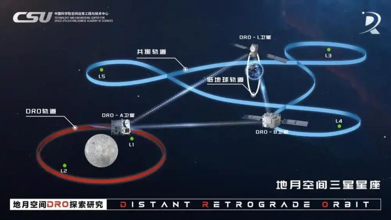
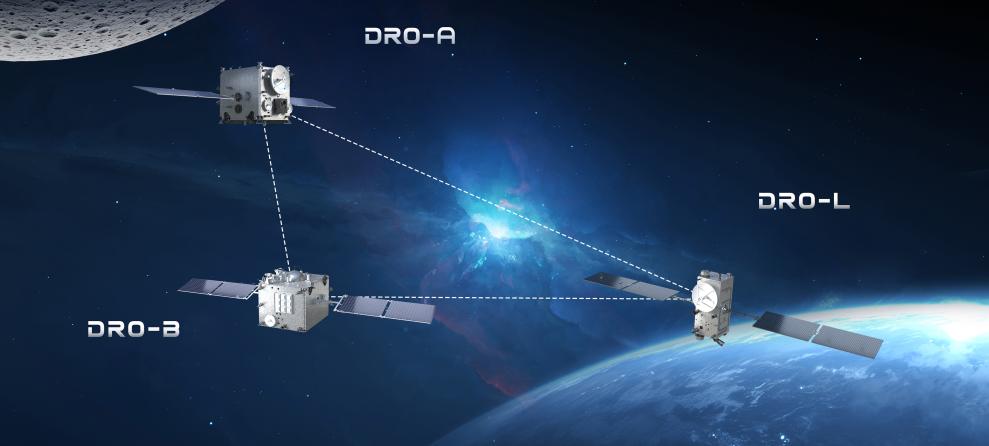
The Technology and Engineering Center for Space Utilization (CSU) of the Chinese Academy of Sciences (CAS) gave this picture. It shows three satellites working together. They are in a special path around the Earth and moon, called the Distant Retrograde Orbit (DRO).

Introduction

China’s recent success in launching its three-satellite constellation marks a revolutionary step in space exploration. This mission, executed in the vast Earth-moon region, demonstrates how the use of a Distant Retrograde Orbit (DRO) can address long-standing challenges in deep-space communication and exploration. With a focus on reducing energy consumption and operational costs, the project has already inspired the global space community by proving that innovative technologies can overcome severe technical obstacles.

The mission involved three different satellites—DRO-A, DRO-B, and DRO-L—each playing a distinct role in advancing our understanding of space dynamics. DRO-L was the first to be launched into a sun-synchronous orbit, where it began critical experiments. DRO-A and DRO-B were launched later from the Xichang Satellite Launch Center in China’s Sichuan Province. Despite an initial setback caused by an anomaly in the carrier rocket’s upper stage, an intense rescue operation ensured that all satellites eventually reached their designated orbits.

Mission Overview and Technological Innovations

The breakthrough in this mission lies in its innovative use of the Distant Retrograde Orbit (DRO). This orbit type, unusual compared to traditional satellite paths, allows spacecraft to operate with minimal energy expenditure. The stability offered by DRO creates a natural hub in space that connects Earth to the moon and even further into deep space. The savings in fuel and operational costs are substantial. This leap in efficiency provides enormous potential for future missions that may include crewed space exploration and advanced scientific research.

Below is a table presenting key details of each satellite:

Satellite Orbit Type Mission Role Launch Date
DRO-A Distant Retrograde Orbit (DRO) Experimentation and autonomous navigation March 13, 2024
DRO-B Maneuver Orbits in Earth-Moon Space Inter-satellite communication and measurement March 13, 2024
DRO-L Near-Earth Orbit Initial experiments and data collection February 3, 2024

The use of DRO represents a pioneering strategy in space engineering. Traditional satellites often require frequent adjustments to maintain their orbits, leading to higher fuel consumption and increased operational risk. By contrast, the DRO method harnesses gravitational forces in both the Earth and moon systems, providing stability over extended periods while requiring only minimal propulsion adjustments. This method is critical in advancing the next generation of space exploration missions.

Technical Details and Overcoming Challenges

During the initial phase of the mission, the satellites encountered significant challenges. An anomaly in the carrier rocket’s upper stage resulted in DRO-A and DRO-B deviating from their planned trajectories. In what many described as a “life-or-death” situation, the satellite team acted swiftly. They executed a series of emergency maneuvers under extreme conditions, successfully reorienting the satellites and guiding them back onto their intended paths after a journey covering 8.5 million kilometers.

The mission’s success was not merely a triumph of engineering under pressure but also a testament to the resilience of the space team. The autonomous navigation systems on board, alongside the real-time adjustments made during the rescue operation, demonstrated that even unforeseen complications could be managed effectively. By establishing inter-satellite and satellite-to-ground communication links using K-band microwave technology, the team ensured that critical data was relayed over distances as vast as 1.17 million kilometers. This technological breakthrough not only confirms the feasibility of DRO but also opens new pathways for cost-effective deep-space monitoring and data collection.

Breakthrough and Future Opportunities

The successful networking of the constellation represents a remarkable breakthrough in satellite technology. It is a prime example of how advanced engineering and innovative problem solving can converge to overcome challenges in the rigorous field of space exploration. The critical achievement of establishing high-precision inter-satellite links has reduced the reliance on prolonged ground-based tracking systems. Instead of two full days of tracking, the new system accomplishes equivalent orbit determination in just three hours.

This dramatic improvement in efficiency is expected to spur a new era of low-cost, autonomous deep-space exploration. Scientists and engineers are now able to plan more ambitious missions, with the possibility of deploying larger constellations to monitor vast areas of space. Future research will likely expand into fields such as quantum mechanics, atomic physics, and the investigation of the lunar environment, leveraging the constant stability provided by DRO.

The mission’s impact is already being felt in international space research circles. By demonstrating a reliable, cost-effective method for long-duration space travel, China’s accomplishments serve as a catalyst for collaborative projects and potential international partnerships. The lessons learned from this mission could lead to innovations that benefit not only the field of space exploration but also terrestrial technologies in communication and navigation.

Below is a timeline summarizing the key events of the mission:

Event Date Description
DRO-L Launch Feb 3, 2024 Satellite entered a sun-synchronous orbit and began executing planned scientific tests.
DRO-A/B Launch March 13, 2024 Satellites launched from Xichang Satellite Launch Center, Sichuan Province, China.
Orbit Correction Post-launch Emergency maneuvers reestablished the proper trajectory after a launch anomaly.
Successful Separation Aug 28, 2024 DRO-A and DRO-B were separated and initiated inter-satellite communication experiments.

International Implications and Future Research

The implications of this mission extend far beyond China’s borders. The successful demonstration of a low-energy, high-efficiency satellite constellation provides a model that other nations and private companies can emulate. As global interest in space exploration continues to grow, the DRO approach presents a promising avenue for reducing launch costs and the operational complexities of extended missions.

This achievement inspires hope for more extensive scientific collaborations and innovative projects that harness similar technologies. The possibility of creating a network of satellites that communicate and operate autonomously could transform how deep-space missions are planned and executed. By laying the groundwork for autonomous orbit determination and low-cost deep-space travel, China has set a new benchmark in the field.

In addition, the successful mission significantly contributes to the understanding of the lunar space environment. It offers scientists valuable data that can lead to breakthroughs in our understanding of gravitational dynamics, cosmic radiation, and the potential for human habitation beyond Earth. The knowledge gathered from this project is expected to influence future research in astronomy, physics, and engineering, driving further technological advances in these areas.

Facts

  • DRO satellites rely on a unique orbital path that reduces the need for frequent propulsion adjustments.
  • The rescue operation that corrected the satellite trajectory was executed under extreme conditions, embodying high-stakes space engineering.
  • The innovative inter-satellite communication methods employed during the mission have the potential to revolutionize data collection in deep space.

References

Innovative Terraforming Techniques to Rapidly Warm Mars for Human Habitation

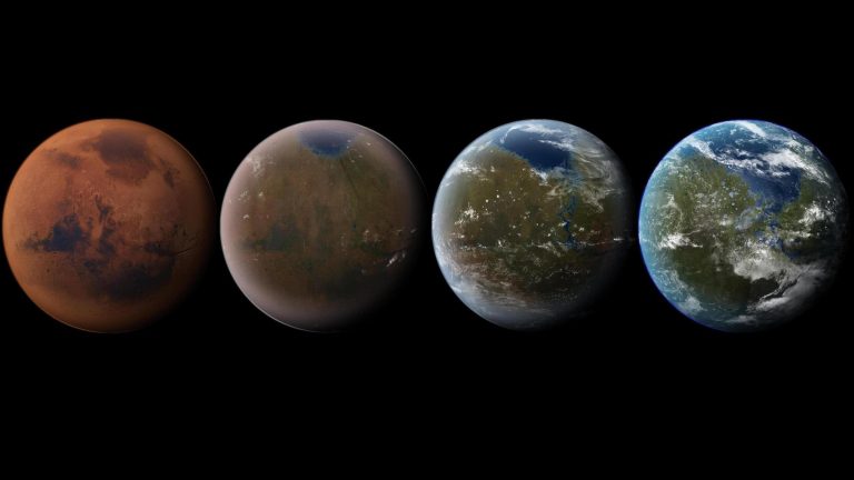
Terraforming Mars to create a more Earth-like environment is a long-term goal of space exploration. One of the first critical steps is warming the Martian atmosphere, which could eventually lead to a thicker atmosphere and melting of the polar caps. A recent study proposes a novel method of warming Mars using nanoscale aerosols made of graphene and aluminum. This method, if proven effective, could be a significant first step in making Mars more hospitable for human life.

Summary

  • Recent studies suggest using graphene and aluminum aerosols to warm Mars’ atmosphere.
  • This is one of the first proposed methods of terraforming Mars.
  • Warming Mars’ atmosphere will help melt the polar ice caps and release water vapor.
  • The melting ice will also release carbon dioxide, further warming the planet.
  • Proposed techniques for increasing Mars’ temperature include adding CFCs, methane, or ammonia to the atmosphere.
  • Warming the atmosphere will thicken it, bringing it closer to Earth-like conditions.
  • Melting the ice caps could result in 300 millibars of atmospheric pressure, enabling humans to survive without a pressure suit, though still needing warm clothing.
  • Researchers from Aeolis Research, NASA’s Jet Propulsion Laboratory, and other institutions have contributed to the study.
  • The University of Chicago’s Edwin S. Kite led the groundbreaking research.
  • The next step in the process involves creating bioregenerative life support systems (BLSS) for humans to live sustainably on Mars.
  • Various theories and proposals have been made for warming Mars, with each method requiring massive resources.
  • Researchers agree that the process of terraforming Mars will take many years and require innovative technologies.

Innovative Terraforming Techniques to Rapidly Warm Mars for Human Habitation

Introduction

Multiple plans exist to explore Mars in the coming decades using robotic and crewed missions. The ultimate goal of these missions is to determine whether human beings could actually live there someday. This requires access to building materials, water, cutting-edge manufacturing technology, and closed-loop habitation systems with bioregenerative life support systems (BLSS). Basically, future settlers will need to create conditions that mimic Earth’s self-sustaining ecological systems – essentially, we need to “take Earth with us” to other planets.

In the long term, these efforts could extend to the entire planet in an effort to make Mars “Earth-like.” This process is known as “terraforming,” and many proposals have been made over the past 50 years. In a recent study, an interdisciplinary team presented a novel way to warm up Mars’ atmosphere using nanoscale aerosols of graphene and aluminum. Their findings indicate that Mars’ atmospheric dynamics and radiative processes make engineered aerosol warming possible, which could constitute the first step in terraforming the planet.

Research Overview

Edwin S. Kite, an associate professor at the University of Chicago and a member of the Curiosity rover’s science team, led the study. He was joined by researchers from the planetary science research Aeolis Research, Northwestern University, the University of Central Florida, the MIT Haystack Observatory, the European Centre for Medium-Range Weather Forecasts (ECMWF), and NASA’s Jet Propulsion Laboratory. The paper describing their findings was presented at the 2025 Lunar and Planetary Science Conference.

The study suggests using nanoscale aerosols made of graphene and aluminum to warm Mars’ atmosphere. Graphene is a single layer of carbon atoms arranged in a two-dimensional lattice, and it is known for its ability to absorb sunlight and heat up when exposed to solar radiation. By dispersing these aerosols into the Martian atmosphere, they could absorb more sunlight, thus increasing the temperature of the atmosphere.

This study, presented at the 2025 Lunar and Planetary Science Conference, is one of the first to propose this method. It highlights how Mars’ unique atmospheric dynamics could make engineered aerosol warming feasible. The concept of using aerosols in this way could offer a scalable and efficient method to kickstart the terraforming process on Mars.

Steps to Terraform Mars

When it comes right down to it, the process of terraforming Mars consists of three interconnected steps:

1. Warming the Atmosphere

The first step, as we’ve discussed, is to increase the temperature of Mars’ atmosphere. Warming the planet would lead to the melting of ice caps and the release of gases like carbon dioxide, further enhancing the greenhouse effect. This is crucial for jumpstarting the terraforming process.

2. Thickening the Atmosphere

Once the temperature increases, the next goal is to thicken the atmosphere to a point where it can support human life. Mars’ current atmospheric pressure is too low for humans to survive without spacesuits. Scientists aim to increase the atmospheric pressure to at least 300 millibars, or 30% of Earth’s sea-level pressure. This would allow humans to walk outside with just warm clothing, though they would still need oxygen tanks.

3. Melting the Polar Caps and Permafrost

The final step in the terraforming process would be to melt Mars’ polar ice caps and permafrost. As the ice melts, it will release water into the atmosphere and onto the surface. Additionally, dry ice (frozen carbon dioxide) in the ice caps will sublimate, releasing carbon dioxide and further thickening the atmosphere.

Potential Methods for Warming Mars

Many methods have been suggested over the years for warming Mars. These include:

  • Low albedo materials: Spreading dark-colored materials over the polar caps to absorb more sunlight.
  • Chlorofluorocarbons (CFCs): Filling the atmosphere with chemicals that trap heat.
  • Methane or ammonia: Introducing gases that would create a stronger greenhouse effect.
  • Carbon dioxide harvesting: Importing carbon dioxide from other planets, like Venus, to thicken Mars’ atmosphere.

The Importance of Warming Mars’ Atmosphere

Mars has a thin atmosphere, mainly composed of carbon dioxide, with very little oxygen or nitrogen like Earth’s. This makes the planet cold, with an average surface temperature of about -60°C. If we are to consider human colonization of Mars, this cold atmosphere presents a significant obstacle. A warmer atmosphere would allow for liquid water to exist on the surface, which is essential for human life.

The warming process would have multiple stages. First, scientists need to increase the temperature of the atmosphere. This could eventually lead to the melting of the polar ice caps, releasing water and carbon dioxide. Once the atmosphere thickens, the pressure would increase, making it more hospitable for human life. But how can this be achieved? Several proposals have emerged over the years, each with its own set of challenges and benefits.

The quest to increase Mars’ temperature is a complex and multifaceted challenge that involves innovative scientific research and technological advancements. As we continue to explore Mars and develop our understanding of its environment, the dream of terraforming the planet may one day become a reality.

Further Reading & Research

How to Power CubeSats Using Deep Learning: Innovative Energy Solutions for Space

CubeSat missions face significant power management challenges, but by integrating deep learning techniques—specifically a deep feedforward neural network linked with traditional control systems—the efficiency of Maximum Power Point Tracking (MPPT) can be greatly enhanced. This innovation not only boosts overall power generation but also reduces fluctuations that may harm sensitive onboard electronics.

Summary

  • CubeSats are small, modular satellites with strict power limitations.
  • Power is primarily generated through solar panels, but environmental factors cause fluctuations.
  • Traditional MPPT algorithms such as Perturb and Observe, Incremental Conductance, and Particle Swarm Optimization offer 88–94% efficiency.
  • A new approach using deep learning (Deep Feedforward Neural Network) integrated with a proportional-integral controller reaches up to 97% efficiency.
  • The algorithm optimizes solar orientation and minimizes power ripple, ensuring stable operations.
  • Despite being computationally intensive, innovative techniques like linear tangents and Neville Interpretation simplify calculations.
  • The deep learning model provides an adaptive solution to unpredictable space conditions.
  • Two comprehensive tables compare CubeSat power system components and MPPT algorithm efficiencies.

Introduction

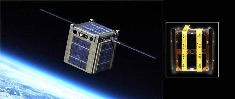
CubeSats are small, modular spacecraft used for various scientific and commercial missions. Designing a CubeSat involves many challenges, and one of the biggest hurdles is powering the satellite efficiently. CubeSats are typically powered by solar panels that deploy from their structured frame. However, their power generation is affected by environmental conditions such as solar radiation fluctuations and temperature variations.

The power system in a CubeSat must be both reliable and efficient. Traditional methods of power management often struggle to keep up with rapid changes in power output. Recent research has shown that deep learning can be integrated into CubeSat power systems to overcome these challenges. This technology helps optimize the Maximum Power Point Tracking (MPPT) process, which is vital for extracting the most power possible from the solar panels.

Design Challenges for CubeSat Power

CubeSat designers face many tradeoffs when choosing solar panels, batteries, and power converters. The physical limitations of CubeSats mean that there is little room to add extra components. Additionally, the harsh space environment exposes the CubeSat to unpredictable changes in sunlight and temperature, which in turn affect the power available.

Power system faults are a major reason behind CubeSat mission failures. Studies have shown that up to 25% of CubeSat missions fail due to issues with power management. This has driven the need for innovative approaches that can adapt to real-time changes in power conditions. By using deep learning algorithms, engineers can design systems that adjust dynamically, ensuring that CubeSats receive the necessary power even in fluctuating conditions.

Deep Learning in CubeSat Power Systems

Traditional MPPT algorithms such as Perturb and Observe (P&O), Incremental Conductance (InC), and Particle Swarm Optimization (PSO) have proven to be effective in achieving efficiencies ranging from 88% to 94%. However, these methods are not adaptive. Their parameters must be predetermined before launch, which limits their effectiveness in an unpredictable space environment.

To overcome these limitations, researchers have developed a Deep Feedforward Neural Network (DFFNN) that works alongside a standard proportional-integral controller. This combination outperforms conventional MPPT algorithms, achieving an efficiency of about 97% in simulated year-long missions. Although deep learning requires significant computational resources, innovative techniques such as linear tangents and Neville Interpretation simplify the calculations needed to determine the CubeSat’s trajectory and power needs.

CubeSat Component Specifications

The following table outlines some key components used in CubeSat power systems along with their specifications:

Component Description Efficiency
Solar Panels Convert sunlight into electrical power Up to 20%
Batteries Store electrical energy for later use Around 85-90%
MPPT Controllers Optimize power extraction from solar panels 88-97% (depending on algorithm)
Deep Learning Processor Processes data for adaptive power management Enhanced performance

Deep Feedforward Neural Network and MPPT Algorithm

The new algorithm uses deep learning to adjust the MPPT process in real-time. This approach is particularly effective when the CubeSat’s orientation to the Sun is not optimal. The algorithm detects changes in solar radiation and quickly recalculates the ideal angle for the solar panels, ensuring maximum power capture.

The integration of a Deep Feedforward Neural Network (DFFNN) is key to this process. The DFFNN is trained on simulated data from long-term CubeSat missions, allowing it to predict and react to changes in power conditions. By doing so, it not only increases efficiency but also minimizes “power ripple”—sudden changes in voltage or current that can harm the CubeSat’s components.

An additional benefit of this deep learning approach is its ability to lower the computational demands using techniques like linear tangents and Neville Interpretation. These methods break down complex polynomial equations into simpler forms, making real-time calculations more feasible in the limited computing environment of a CubeSat.

MPPT Algorithm Comparison

The table below compares traditional MPPT algorithms with the new deep learning approach:

Algorithm Efficiency Adaptability Computational Demand
Perturb and Observe (P&O) 88% Low Low
Incremental Conductance (InC) 90% Low Moderate
Particle Swarm Optimization 94% Moderate High
Deep Learning DFFNN 97% High High (optimized with new techniques)

The improved efficiency of the deep learning method, even by a small percentage, is significant in the context of CubeSat missions. Every watt counts when space and weight are limited, and these small improvements can ultimately determine mission success.

Benefits for Space Missions

Improving the power efficiency of CubeSats using deep learning has several benefits. Higher efficiency means that CubeSats can perform longer missions and collect more data. Reduced power ripple also leads to less wear and tear on the electronic components, enhancing the overall lifespan of the spacecraft.

The approach also offers flexibility. Instead of having fixed parameters for power management, CubeSats can now adapt to varying conditions in space. This dynamic adaptability increases the reliability of CubeSat missions and can be crucial during critical operations like data collection or scientific experiments.

CubeSat missions have already begun exploring these new technologies. For example, you can learn more about the innovative approach in the Deep Learning-Based MPPT Approach to Enhance CubeSat Power Generation paper. Other exciting missions include a 3U CubeSat designed for asteroid flybys, a CubeSat mission for detecting X-rays from GRBs and black-hole mergers, and the first CubeSat equipped with a Hall-Effect Thruster. Video resources on this topic are available at this link and this link.

Facts

  • CubeSats were first introduced as educational tools but now play a major role in space research.
  • Modern CubeSats can perform complex tasks like Earth observation and scientific experiments.
  • The integration of deep learning in space technology is a relatively new but fast-growing field.
  • Even a small efficiency gain in CubeSat power systems can lead to major improvements in mission outcomes.
  • Innovative algorithms reduce not only power ripple but also the risk of component failure.

References

Low Earth Orbit Tech: Giant Catapult Sends Satellites Into Space Without Using Rocket Fuel

SpinLaunch, a California-based company, is revolutionizing satellite launches with a kinetic launch system that eliminates the need for rocket fuel. Using a giant rotating arm powered by electricity, it can send payloads into orbit at high speeds, reducing costs and environmental impact. The technology, inspired by medieval siege engines, has already completed successful test flights. If scalable, SpinLaunch’s system could transform space transportation by offering a sustainable and efficient alternative to traditional rockets.

Summary

  • SpinLaunch’s Kinetic Launch System: Employs a massive rotating arm powered by electricity to hurl satellites into space, eliminating the need for rocket fuel.
  • Environmental and Cost Benefits: This method reduces both the financial costs and environmental impacts associated with traditional rocket launches.
  • Successful Test Flights: The company has completed multiple successful test flights, demonstrating the viability of their technology.
  • Historical Inspiration: The concept draws from ancient siege engines like trebuchets, which used kinetic energy to launch projectiles.
  • Modern Materials and Electronics: Advancements in carbon fiber and miniaturized electronics are crucial to the system’s success.
  • Collaborations and Funding: SpinLaunch has secured significant funding and partnerships with organizations such as NASA and Airbus.
  • Future Plans: The company aims to deploy satellite constellations into orbits below 600 miles by 2026.


𝐒𝐚𝐭𝐞𝐥𝐥𝐢𝐭𝐞 𝐋𝐚𝐮𝐧𝐜𝐡𝐢𝐧𝐠 𝐖𝐢𝐭𝐡𝐨𝐮𝐭 𝐑𝐨𝐜𝐤𝐞𝐭 𝐅𝐮𝐞𝐥

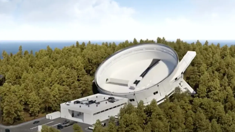
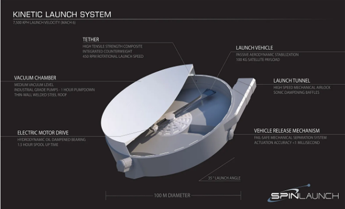
SpinLaunch is challenging the long-standing reliance on chemical rockets by developing a kinetic launch system. Instead of burning massive amounts of fuel, the system uses a large vacuum-sealed centrifuge to accelerate satellites and other payloads before hurling them into the upper atmosphere.

The principle behind this approach is not new—medieval trebuchets used similar kinetic energy concepts to launch projectiles. However, modern materials, electronics, and engineering advancements have made it possible to scale this method for space launches.

𝐇𝐨𝐰 𝐒𝐩𝐢𝐧𝐋𝐚𝐮𝐧𝐜𝐡 𝐖𝐨𝐫𝐤𝐬

SpinLaunch’s orbital accelerator is essentially a massive, high-speed spinning arm enclosed in a vacuum chamber. Here’s how it functions:

  • A payload (satellite or spacecraft) is attached to the rotating arm inside the chamber.
  • The system spins the payload at incredible speeds (up to 5000 mph) using electric motors.
  • At the precise moment, the arm releases the payload, flinging it into space.

Unlike rockets, this system does not require staging, meaning there are no parts to be discarded mid-flight.

𝐀𝐝𝐯𝐚𝐧𝐭𝐚𝐠𝐞𝐬 𝐎𝐟 𝐊𝐢𝐧𝐞𝐭𝐢𝐜 𝐋𝐚𝐮𝐧𝐜𝐡𝐞𝐬

  • Lower cost: Fuel is one of the largest expenses in traditional rocket launches. SpinLaunch eliminates this entirely.
  • Eco-friendly: No carbon emissions or fuel combustion reduces environmental damage.
  • High launch frequency: The system can launch satellites multiple times a day without requiring extensive refurbishment.

𝐂𝐡𝐚𝐥𝐥𝐞𝐧𝐠𝐞𝐬 𝐅𝐨𝐫 𝐒𝐩𝐢𝐧𝐋𝐚𝐮𝐧𝐜𝐡

While the idea is promising, several technical hurdles remain:

  • Extreme G-forces: The payload must withstand forces of up to 10,000 Gs, requiring special engineering.
  • Atmospheric resistance: The object must pierce through the lower atmosphere at high speeds.
  • Payload limitations: Currently, only small satellites can be launched, as the system is not designed for human travel.
Low Earth Orbit Tech Giant Catapult Sends Satellites Into Space Without Using Rocket Fuel (2)
SpinLaunch has created a system called the kinetic launch system. This system can send objects into space. The process involves using a large spinning arm. The arm throws objects into the sky at high speeds. This is different from traditional rockets. Rockets use a lot of fuel to escape Earth’s gravity. The kinetic launch system uses less fuel. It relies on spinning energy instead. SpinLaunch is the company that developed this technology. They believe it is a more efficient way to reach space.

𝐎𝐭𝐡𝐞𝐫 𝐈𝐧𝐧𝐨𝐯𝐚𝐭𝐢𝐯𝐞 𝐋𝐚𝐮𝐧𝐜𝐡 𝐌𝐞𝐭𝐡𝐨𝐝𝐬

SpinLaunch is not the only company reimagining space travel. Other exciting satellite launch alternatives include:

Technology Developer Key Benefit
Reusable Rockets SpaceX Reduces costs by landing and reusing boosters
Air-Launched Rockets Virgin Orbit Flexible launch locations
3D-Printed Rockets Relativity Space Faster, cheaper manufacturing
Space Tugs Momentus Moves satellites after launch

Each of these alternative launch methods contributes to making space more accessible, reducing dependence on traditional rocket launches.

𝐓𝐡𝐞 𝐅𝐮𝐭𝐮𝐫𝐞 𝐎𝐟 𝐒𝐩𝐢𝐧𝐋𝐚𝐮𝐧𝐜𝐡

SpinLaunch has already completed multiple successful test flights and is now working toward building a coastal launch facility for orbital launches.

Their next steps include:

  • Developing a larger system to support heavier payloads.
  • Partnering with organizations like NASA, Airbus, and Cornell University.
  • Expanding their system to be a primary method of small satellite deployment.

If successful, kinetic launch technology could redefine the economics of space travel.

𝐅𝐚𝐜𝐭𝐬 𝐀𝐛𝐨𝐮𝐭 𝐊𝐢𝐧𝐞𝐭𝐢𝐜 𝐋𝐚𝐮𝐧𝐜𝐡

  • SpinLaunch’s system is 10 times more energy efficient than chemical rockets.
  • NASA’s cannon-launched projectiles inspired parts of this design.
  • The launch speed is faster than a bullet! SpinLaunch hurls objects at Mach 6 speeds.
  • Ancient war machines like trebuchets used similar physics.

𝐑𝐞𝐟𝐞𝐫𝐞𝐧𝐜𝐞𝐬

#SpaceInnovation, #SpinLaunch, #KineticLaunch, #SatelliteTech, #EcoFriendlySpace, #RocketlessLaunch, #LEO, #SpaceRevolution, #NewSpaceRace, #FutureOfSpace, #NoRocketFuel, #NextGenLaunch, #SpaceTech, #OrbitalAccess, #Spaceflight

Positioning System Upgrade: Japan Launches Satellite for Independent GPS Network

Japan has successfully launched the Michibiki 6 satellite using its H3 rocket, enhancing its Quasi-Zenith Satellite System (QZSS) to improve positioning accuracy for various applications, moving towards greater independence from foreign GPS services.

Summary

  • Launch Details: On February 2, 2025, Japan’s space agency, JAXA, successfully launched the Michibiki 6 satellite aboard the H3 rocket from the Tanegashima Space Center.
  • Quasi-Zenith Satellite System (QZSS): The QZSS is Japan’s regional satellite navigation system, designed to enhance GPS accuracy in the Asia-Oceania region, particularly over Japan.
  • System Expansion: With the addition of Michibiki 6, the QZSS now comprises five satellites, with plans to expand to seven by March 2026 and eleven by the late 2030s, aiming for more precise global positioning without relying on foreign services.
  • Applications: The enhanced system will improve positioning data for smartphones, vehicles, maritime navigation, and drones, benefiting various industries and daily activities.
  • H3 Rocket Development: The successful launch marks the fourth consecutive successful flight for the H3 rocket, following a previous failed debut, and aims to make Japan’s space transport commercially competitive and bolster national security.

Introduction

In a significant stride towards enhancing its autonomous navigation capabilities, Japan has successfully launched the Michibiki 6 satellite, bolstering its Quasi-Zenith Satellite System (QZSS). This development not only aims to improve positioning accuracy for various applications but also signifies Japan’s move towards reducing reliance on foreign GPS services.

The Quasi-Zenith Satellite System (QZSS)

The QZSS, also known as Michibiki, is a regional satellite navigation system developed by Japan to enhance the United States-operated Global Positioning System (GPS) in the Asia-Oceania regions, with a focus on Japan. The system is designed to provide highly precise and stable positioning services, especially in urban and mountainous areas where GPS signals can be obstructed.

Launch Details

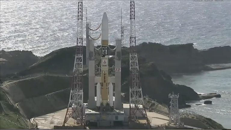
On February 2, 2025, at 5:30 p.m. JST, the Japan Aerospace Exploration Agency (JAXA) successfully launched the Michibiki 6 satellite aboard the H3 rocket from the Tanegashima Space Center in Kagoshima Prefecture. Approximately 29 minutes after liftoff, the satellite was successfully placed into its target orbit.

Enhancing Positioning Accuracy

The addition of Michibiki 6 to the QZSS constellation is expected to significantly improve positioning data for various applications. This includes enhanced accuracy for smartphones, car navigation systems, maritime navigation, and drones. The system’s design ensures that at least one satellite is always near the zenith over Japan, providing a more reliable signal in areas where traditional GPS signals may be weak or obstructed.

System Expansion Plans

Currently, the QZSS consists of five satellites with the inclusion of Michibiki 6. Japan plans to expand this constellation to seven satellites by March 2026, aiming to achieve more precise global positioning capabilities without relying on foreign services. By the late 2030s, the system is expected to comprise eleven satellites, further enhancing its accuracy and reliability.

Applications Across Industries

The enhanced QZSS is poised to benefit a wide range of industries:

  • Automotive: Improved navigation systems with higher accuracy, essential for the advancement of autonomous driving technologies.
  • Maritime: More precise navigation aids for vessels, contributing to safer and more efficient maritime operations.
  • Aviation: Enhanced flight navigation and management systems, leading to improved safety and operational efficiency.
  • Agriculture: Support for precision farming techniques, allowing for more efficient resource utilization and crop management.
  • Disaster Management: Accurate positioning data to assist in emergency response and disaster relief operations.

H3 Rocket Development

The successful deployment of Michibiki 6 also marks a significant milestone for Japan’s H3 rocket program. This launch represents the fourth consecutive successful flight for the H3 rocket, following a previous failed debut. The H3 rocket is a key component of Japan’s strategy to establish a stable and commercially competitive space transport capability, which is crucial for both its space program and national security.

Table 1: Comparison of QZSS and GPS

Feature QZSS (Japan) GPS (USA)
Primary Region of Coverage Japan & Asia-Pacific Global
Number of Satellites 5 (expanding to 11) 31 operational
Orbit Type Quasi-Zenith Orbit (QZO) Medium Earth Orbit (MEO)
Accuracy Higher in urban areas Varies by region
Independence Aims for self-reliance Used globally

Table 2: Key Missions of the H3 Rocket

Launch Number Date Payload Mission Outcome
1st (Failed) March 7, 2023 ALOS-3 (Earth Observation) Failure
2nd (Success) February 17, 2024 Small Satellites Success
3rd (Success) September 2024 Unmanned Cargo to ISS Success
4th (Success) February 2, 2025 Michibiki 6 (QZSS) Success

The successful launch of Michibiki 6 signifies a major advancement in Japan’s efforts to develop an independent and highly accurate satellite navigation system. With plans for further expansion and enhancement, the QZSS is set to provide significant benefits across various industries, contributing to technological innovation and improved quality of life.

Facts

  • The term “Michibiki” translates to “guidance” in Japanese, reflecting the satellite’s purpose in providing precise navigation assistance.
  • Unlike traditional GPS satellites that orbit the Earth in a medium Earth orbit (MEO), QZSS satellites operate in a quasi-zenith orbit (QZO), ensuring better coverage over Japan.
  • Japan plans to fully transition to a standalone QZSS network, reducing dependence on the U.S. GPS system.
  • The QZSS is designed to provide an accuracy of up to a few centimeters when combined with ground-based augmentation systems.
  • Michibiki 6 is expected to operate for at least 15 years, contributing to Japan’s long-term satellite navigation goals.

References

#JapanGPS, #Michibiki6, #QZSS, #SatelliteNavigation, #H3Rocket, #JAXA, #SpaceTech, #NavigationSystem, #PrecisionGPS, #SatelliteLaunch, #AsiaPacificGPS, #JapanSpace, #AutonomousNavigation, #FutureTech, #SpaceExploration

Vodafone Sets Record with First Video Call via Satellite Technology

Vodafone has achieved a major milestone in mobile communication by successfully conducting the world’s first-ever satellite-based video call using a standard smartphone. This groundbreaking development, made possible through a partnership with AST SpaceMobile, represents a significant leap in global connectivity, particularly for remote and underserved regions.

This advancement is set to revolutionize mobile networks by enabling direct smartphone-to-satellite communication, eliminating coverage gaps, and ensuring universal access to mobile services.

Summary

  • Historic Milestone: Vodafone’s engineers initiated a video call from a remote area in the Welsh mountains, devoid of traditional network signals, connecting directly via satellite to CEO Margherita Della Valle.
  • Technological Collaboration: This achievement was made possible through a partnership with AST SpaceMobile, utilizing their BlueWalker 3 test satellite, which boasts the largest commercial communications array deployed in low Earth orbit.
  • Standard Smartphone Usage: The call was conducted using an unmodified Samsung Galaxy S22 smartphone, highlighting the capability of standard devices to connect directly to satellites without specialized equipment.
  • Low Earth Orbit (LEO) Satellites: Operating approximately 500 km above Earth, LEO satellites like BlueWalker 3 offer reduced latency and faster data speeds compared to traditional geostationary satellites.
  • Beamforming Technology: The use of beamforming allows precise direction of radio signals from satellites to their intended destinations, enhancing speed and reliability while minimizing interference.
  • Future Deployment Plans: Vodafone aims to roll out this satellite-based mobile broadband service across Europe later this year and into 2026, focusing on eliminating coverage gaps in rural and remote areas.
  • Industry Partnerships: Investors in AST SpaceMobile include major companies like AT&T, Verizon, and Google, indicating a broad industry commitment to advancing satellite-based mobile connectivity.
  • Comparison to Existing Services: Unlike current satellite messaging services offered by companies such as Apple and T-Mobile, Vodafone’s solution provides a complete mobile broadband experience, including voice, text, and video data transmission.
  • Potential Applications: This technology is poised to enhance connectivity in remote areas, support emergency communications, and contribute to closing the digital divide by providing internet access to underserved populations.
  • Technical Specifications: The system demonstrated download speeds of nearly 14 Mbps during testing, supporting activities such as video chatting, web browsing, and streaming of up to 8K video.
  • Historical Context: This achievement comes 40 years after the UK’s first mobile phone call, marking a significant evolution in mobile communication technology.
  • Global Connectivity Goals: Vodafone’s initiative aligns with broader efforts to provide universal mobile coverage, ensuring that even the most remote areas have access to reliable communication services.
  • Environmental Considerations: Utilizing LEO satellites offers a more sustainable approach to expanding network coverage, as they require less power and have a smaller environmental footprint compared to traditional infrastructure.
  • Regulatory and Licensing: Successful implementation of this technology will involve navigating regulatory frameworks and obtaining necessary licenses to operate satellite-based mobile services across different regions.
  • Future Prospects: As the technology matures, it is expected to support higher data rates and more advanced services, further integrating satellite and terrestrial networks for seamless global connectivity.

The Future of Mobile Communication: Vodafone’s Satellite Video Call Breakthrough

On January 29, 2025, Vodafone made history by successfully conducting the world’s first-ever satellite video call using a standard smartphone. This breakthrough eliminates the need for terrestrial mobile towers, offering a revolutionary solution for connectivity in remote areas.

This historic event took place in a rural location in Wales, an area with no conventional network coverage. Using AST SpaceMobile’s BlueWalker 3 satellite, Vodafone engineers placed a seamless video call to CEO Margherita Della Valle, demonstrating that any smartphone can now connect directly to satellites, just as easily as it connects to cell towers.

How the Technology Works

At the heart of this development is AST SpaceMobile’s satellite technology, which allows direct smartphone-to-satellite communication. Unlike existing satellite phones, which require bulky antennas and special hardware, this innovation works with off-the-shelf smartphones.

Key Features of the Technology:

Feature Details
Satellite Name BlueWalker 3
Orbit Type Low Earth Orbit (LEO)
Altitude ~500 km
Download Speed Up to 14 Mbps
Beamforming Directs signal to mobile users
Latency Lower than geostationary satellites
Coverage Area Remote and rural regions

The Role of AST SpaceMobile

AST SpaceMobile is a leading satellite broadband company specializing in direct-to-mobile services. Their BlueWalker 3 satellite, which enabled Vodafone’s historic call, has the largest commercial communications array ever deployed in LEO.

By forming partnerships with Vodafone, AT&T, and other major carriers, AST SpaceMobile aims to expand global mobile coverage without requiring expensive cell tower infrastructure.

Advantages Over Traditional Mobile Networks

Vodafone’s satellite connectivity outperforms traditional mobile networks in several ways:

1. Coverage Expansion

Unlike traditional cell towers, which require physical infrastructure, satellites provide instant connectivity to previously unreachable regions.

2. Emergency and Disaster Response

This technology is particularly valuable for emergency responders, enabling communication in areas affected by earthquakes, hurricanes, or wildfires.

3. Reduced Infrastructure Costs

Building mobile towers in remote areas is expensive and logistically difficult. Satellite-based networks eliminate this need, offering cost-effective connectivity.

4. No Specialized Equipment Required

Current satellite-based messaging services, such as Apple’s Emergency SOS via Satellite, require special hardware. Vodafone’s service works on regular smartphones.

5. Higher Speeds and Reliability

Unlike geostationary satellites, which suffer from high latency, LEO satellites provide faster and more reliable connections.

Vodafone Sets Record with First Video Call via Satellite Technology
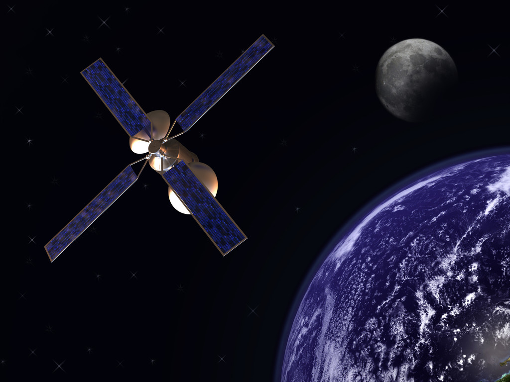
Communication satelite in earth orbit with moon in background

Vodafone’s Future Expansion Plans

Vodafone plans to roll out satellite-based mobile broadband across Europe by 2025-2026, with further expansion to Africa and Asia in later phases.

The company is working with regulators and governments to secure spectrum licensing, ensuring seamless integration with existing mobile networks.

Region Projected Rollout Year Key Focus Areas
Europe 2025-2026 Rural connectivity
Africa 2026+ Digital inclusion
Asia 2027+ Expanding mobile access

Comparison with Competitors

Vodafone’s satellite mobile broadband faces competition from companies like SpaceX (Starlink), Apple, and T-Mobile. However, its unique direct-to-smartphone approach sets it apart.

Company Technology Services Offered
Vodafone LEO Satellites Full mobile broadband (voice, text, video)
Apple Emergency SOS Limited satellite texting
T-Mobile & Starlink Starlink Satellites Satellite messaging & limited voice
Amazon Project Kuiper LEO Satellites Satellite internet (not direct-to-phone)

Unlike its competitors, Vodafone’s service supports full mobile functionality, making it a true alternative to traditional networks.

Vodafone’s satellite-based video call marks the beginning of a new era in mobile communication. This achievement not only ensures universal mobile coverage but also opens new opportunities for global connectivity, disaster response, and digital inclusion.

As satellite technology advances, we can expect faster speeds, better reliability, and even global 5G coverage—all from a standard smartphone.

Facts

  • Historical First: In 2013, mountaineer Daniel Hughes made the first video call from the summit of Mount Everest using an HTC One smartphone, streaming the video via satellite to the BBC.
  • Satellite Speed: LEO satellites orbit the Earth at speeds of approximately 7.8 km/s, allowing them to circle the planet in about 90 minutes.
  • Beamforming Origins: Beamforming technology, now used in satellite communications, was originally developed for radar and sonar applications during World War II.

References

  • Vodafone makes world’s first satellite video call using standard smartphoneReuters
  • Vodafone makes ‘world’s first’ satellite video call from a regular phone ahead of 2025 rolloutThe Verge
  • Vodafone makes world’s first space video call from an area of no mobile coverageVodafone News
  • Vodafone makes satellite video call using standard phoneRCR Wireless News
  • Vodafone demonstrates ‘world’s first’ satellite video call with a standard mobile phoneEngadget
  • Vodafone does the first video call over satellite that uses a regular cellphoneGSMArena
  • Vodafone makes the world’s first-ever satellite video call with basic smartphoneThe Times of India
  • AST SpaceMobile, Starlink Rival, Jumps On Long-Term Vodafone DealInvestor’s Business Daily
  • Brits will ALWAYS have mobile phone & internet signal after tech breakthrough that beats Elon Musk’s StarlinkThe Sun
  • Making a historic direct-to-device satellite video call from a standard smartphoneYouTube
#Vodafone, #SatelliteCommunication, #ASTSpaceMobile, #MobileTechnology, #5G, #SpaceTech, #TelecomInnovation, #GlobalConnectivity, #DigitalInclusion, #TechBreakthrough

SpaceX Recovers Booster but Loses Starship in Ambitious Test Flight

SpaceX achieved a significant milestone with the recovery of its Super Heavy booster during its seventh Starship test flight. However, the mission also faced challenges, as the upper stage, Ship 33, failed during ascent. The test shows both the risks and progress in developing reusable spaceflight technology. Reusable spaceflight technology refers to spacecraft that can be used multiple times for missions. This means the same spaceship can go to space, come back, and then go again. Developing this technology is a big step forward. But there are also challenges and dangers involved.

Summary

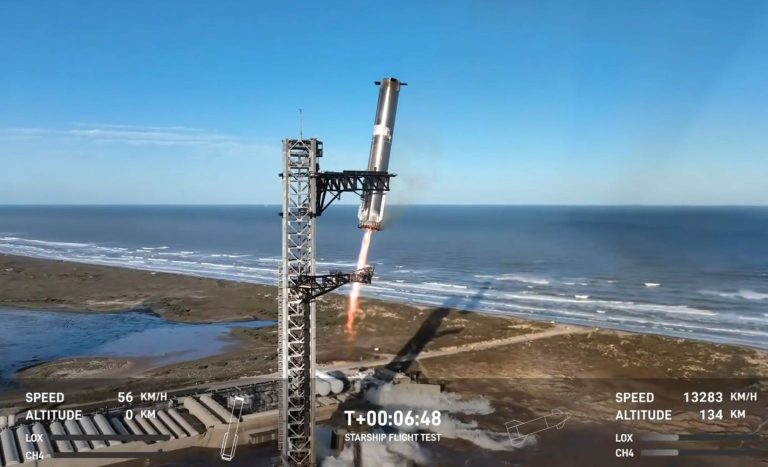
  • Super Heavy Booster Recovery: SpaceX successfully recovered the Super Heavy booster using “Mechazilla,” marking the second time the chopstick-style arms caught the booster above ground.
  • Upper Stage Failure: The upper stage, Ship 33, experienced a “rapid unscheduled disassembly” (RUD) during ascent due to an oxygen/fuel leak near the engine firewall, according to Elon Musk’s post.
  • Improved Design Features: Ship 33 featured upgraded avionics, propulsion systems, forward control flaps, and next-generation heat shield tiles. A backup layer of heat-resistant material was also stress-tested.
  • Impact of Failure: The FAA briefly slowed or diverted aircraft to avoid falling debris from the incident, per official reports.
  • Test Objectives: Ship 33 was designed to deploy 10 Starlink simulators to test deployment procedures for future satellite launches.
  • Starship System Overview: Starship is the world’s most powerful launch vehicle, with 33 Raptor engines producing 16.7 million pounds of thrust. The system is fully reusable and stands 403 feet tall.
  • SpaceX’s Ambitions: Future missions aim to achieve full reuse of both Super Heavy and Ship, as well as interplanetary exploration, including uncrewed Mars missions by 2026 and crewed missions within four years.
  • Historical Context: The test showcased advances over previous missions, such as last October’s first successful booster catch using the “Mechazilla” system.
  • Applications for NASA: A customized Starship version is planned for NASA’s Artemis III lunar mission, expected by mid-2027.
  • Future Upgrades: Musk outlined plans to double-check for leaks, add fire suppression systems, and expand venting capacity for subsequent launches.

Introduction

SpaceX’s seventh test flight of its massive Starship system had both successes and failures. The company made progress in reusability by successfully recovering the Super Heavy booster. However, the upper part of the rocket, called Ship 33, experienced a major problem while going up. This issue ended the test early. Even with this setback, SpaceX is dedicated to improving the system. They want to achieve big goals, like missions to Mars and further.

Starship and Super Heavy: Engineering Marvels

The Starship launch system consists of two main components: the Super Heavy booster and the Starship upper stage. Together, they create the most powerful rocket system ever built, capable of producing 16.7 million pounds of thrust.

  • Super Heavy Booster: Equipped with 33 methane-fueled Raptor engines, the booster provides the initial thrust required for liftoff. Its reusability is a major focus, as demonstrated by the successful catch during this mission.
  • Starship Upper Stage: This stage is designed for tasks like satellite deployment, crewed lunar landings, and eventually Mars exploration. Ship 33, used in this test, included several design upgrades, such as next-generation heat shield tiles and improved avionics.

Learn more about Starship’s technical specifications here.

What Went Right: Super Heavy’s Recovery

For only the second time in SpaceX’s testing history, the Super Heavy booster was successfully caught by the Mechazilla system. This innovative approach uses mechanical arms on the launch tower to secure the returning booster mid-air.

This achievement builds on the first successful catch in October 2024, further validating SpaceX’s plans for fully reusable rocket systems.

Watch the October 2024 booster catch here.

What Went Wrong: Ship 33’s RUD

Unfortunately, the upper stage, Ship 33, failed to complete its mission. According to SpaceX, the failure occurred due to an oxygen/fuel leak near the engine firewall. This resulted in a “rapid unscheduled disassembly” (RUD) during ascent.

Elon Musk explained the failure in a post on X:

“Preliminary indications suggest a leak in the cavity above the engine firewall led to pressure buildup. Future improvements will include fire suppression and enhanced venting systems.”

The debris from Ship 33’s breakup created temporary disruptions to commercial air traffic, as noted by the FAA’s report.

Aiming for the Stars: SpaceX’s Vision

  • Satellite Deployment: SpaceX plans to use Starship for large-scale launches of its Starlink satellites to low Earth orbit (LEO). This test included mock Starlink payloads.
  • NASA Collaboration: A custom Starship variant is set to land astronauts on the Moon as part of NASA’s Artemis III mission, scheduled for no earlier than mid-2027.
  • Mars Missions: SpaceX envisions sending uncrewed Starships to Mars by 2026, followed by crewed missions four years later.

Read about SpaceX’s Mars plans in Elon Musk’s post.

Technical Challenges and Next Steps

Ship 33’s failure underscores the complexity of developing a fully reusable rocket system. To address the issues, SpaceX plans to:

  • Improve Leak Detection: Enhanced quality control processes to detect potential leaks before launch.
  • Add Fire Suppression Systems: New measures to extinguish potential fires in critical areas.
  • Expand Venting Capacity: Increased venting to manage pressure buildup during ascent.

These upgrades aim to support SpaceX’s goal of monthly Starship launches in the near future.

Follow SpaceX’s updates on future launches here.

Comparison: Starship vs. Competitors

The Starship system stands apart from other launch systems in terms of thrust and reusability.

Feature SpaceX Starship NASA’s SLS Saturn V
Liftoff Thrust 16.7 million pounds 8.8 million pounds 7.5 million pounds
Reusability Fully reusable None None
Height 403 feet 322 feet 363 feet

Explore more about Starship’s capabilities here.

Facts About Starship

  • Largest Rocket Ever Built: At 403 feet tall, Starship surpasses both the Saturn V and NASA’s SLS in size.
  • Twice the Thrust: Starship generates nearly twice the thrust of the Apollo-era Saturn V rocket.
  • Fully Reusable: Unlike NASA’s SLS, Starship is designed to be fully reusable, significantly reducing launch costs.

Watch Starship in action during its latest test flight.

Challenges Ahead: FAA Oversight and Safety

Following the RUD incident, the FAA has pledged to investigate the root cause and ensure compliance with safety protocols.

The FAA’s statement read:

“The FAA briefly slowed and diverted aircraft around the area where space vehicle debris was falling. Normal operations have resumed.”

This highlights the growing need for safety measures in the burgeoning field of commercial space travel.

Learn about FAA’s role in spaceflight safety here.

Looking Ahead: Ambitions for Mars and Beyond

SpaceX’s ultimate vision is to establish a self-sustaining city on Mars within the next two decades. Musk believes this requires exponential growth in flight frequency and reliability.

A timeline for Mars missions includes:

  • 2026: First uncrewed Mars landings.
  • 2028: Initial crewed missions if uncrewed tests are successful.
  • 2040s: Self-sustaining city established.

See Elon Musk’s vision for humanity on Mars here.

SpaceX’s seventh Starship test exemplifies both the risks and rewards of pushing the boundaries of space exploration. While the loss of Ship 33 underscores the challenges ahead, the successful recovery of the Super Heavy booster demonstrates SpaceX’s ongoing commitment to full reusability.

As SpaceX continues to refine its technology, the possibilities for humanity’s interplanetary future remain boundless.

References

  1. Elon Musk’s update on X
  2. SpaceX’s Starship Overview
  3. Cosmic Log Article on Booster Recovery
  4. Reuters Article on the Test Flight
  5. Watch the Test Flight on YouTube
#SpaceX, #Starship, #SuperHeavyBooster, #ElonMusk, #SpaceExploration, #MarsMissions, #ReusableRockets, #FAA, #Starlink, #LunarLanding, #ArtemisIII, #RocketScience, #NextGenHeatShield, #StarshipDebris, #SpaceTech

Venus Missions: How Scientists Plan to Deploy and Talk to Leaves

Scientists are exploring innovative methods to study Venus’ hostile atmosphere through projects like LEAVES (Lofted Environmental and Atmospheric Venues Sensors). This futuristic technology employs small, cost-efficient sensors to collect atmospheric data while navigating Venus’ dense clouds. Complementary spacecraft designs ensure data transmission back to Earth, marking a potential breakthrough in understanding Venus’ mysteries.

Summary

  • Venus’ harsh environment challenges conventional technology, making lightweight, innovative sensors like LEAVES essential for exploration.
  • LEAVES technology is designed to operate from 100 km to 30 km altitudes, gathering crucial data on pressure, temperature, and atmospheric composition.
  • These probes work autonomously without propulsion, gliding down while sending back data.
  • WPI undergraduates proposed a complementary mission, using two satellites—Demeter and Persephone—to deploy and communicate with LEAVES.
  • Demeter orbits Venus at 235 km altitude, deploying 144 probes along specific latitudes.
  • Persephone, at 2000 km orbit, relays data from LEAVES to Earth.
  • The distribution of LEAVES aims to analyze day-night differences in atmospheric chemistry, especially focusing on the sulfur dioxide cycle.
  • Both spacecraft boast high Technology Readiness Levels (TRL-9) except for the LEAVES deployment system (TRL-1 to 2), which requires further testing.
  • No concrete timeline exists yet, as LEAVES is in its developmental phase, supported by NIAC funding.
  • This mission is a step toward unlocking Venus’ secrets, potentially inspiring future planetary exploration.

Read more about the WPI team’s research here.

Venus’ Unforgiving Atmosphere

Venus is renowned for its extreme surface conditions—scorching temperatures exceeding 450°C and an atmosphere filled with concentrated sulfuric acid. These factors create significant challenges for scientists aiming to explore the planet in-depth. Traditional spacecraft and instruments often fail to endure Venus’ harsh environment, driving researchers to seek more robust alternatives.

LEAVES, short for Lofted Environmental and Atmospheric Venues Sensors, was conceived as a potential solution. According to Universe Today, LEAVES represents an innovative approach to studying Venus’ atmosphere from 100 km to 30 km altitudes, where intriguing atmospheric phenomena occur.

These tiny probes, equipped with basic sensors, are capable of collecting valuable data such as:

  • Local atmospheric pressure.
  • Temperature fluctuations.
  • Chemical composition, including the concentration of carbon monoxide.
  • Orientation data, leveraging inertial measurement units similar to those found in drones.

How LEAVES Work

Unlike traditional spacecraft, LEAVES operate without propulsion systems. They glide autonomously through the atmosphere, relying on Venus’ winds for movement. Their low cost and disposable nature make them an ideal candidate for missions where resilience and affordability are key.

Although their operational lifespan is short, the data they provide could answer several critical questions, including:

  • What compound absorbs near-ultraviolet light in Venus’ upper atmosphere?
  • How does the sulfur dioxide cycle vary between the planet’s day and night sides?

For more details on the LEAVES project, watch this video by Cosmic Voyages.

Venus Missions How Scientists Plan to Deploy and Talk to Leaves
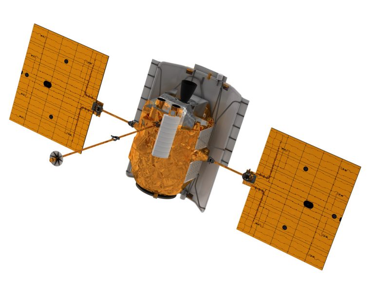
Demeter-Mockup

Demeter and Persephone: The Dual-Satellite Solution

To enhance LEAVES’ efficiency, a team of undergraduates from Worcester Polytechnic Institute (WPI) developed a mission design involving two satellites: Demeter and Persephone.

Demeter’s Role

Demeter is tasked with deploying LEAVES into Venus’ atmosphere. Here’s how it works:

  • Demeter orbits Venus at an altitude of 235 km.
  • It carries 144 LEAVES, housed in 18 miniature compartments.
  • Using small hydrazine-based rocket boosters, Demeter releases eight probes every 20° of latitude around the planet.
  • The deployment pattern ensures coverage of both equatorial and polar regions.

At approximately 150 km altitude, each LEAVES probe deploys its glide form, descending through Venus’ atmosphere. By 100 km, the sensors begin transmitting data to Persephone.

Persephone’s Role

Persephone plays the vital role of a communication relay. Positioned at a higher 2000 km orbit, it collects weak signals from LEAVES and transmits them back to Earth. Its high-gain antenna and onboard storage system ensure the seamless transfer of atmospheric data.

For additional insights, explore Cosmic Voyages’ coverage of the mission.

Table 1: Satellite Specifications

Feature Demeter Persephone
Orbit Altitude 235 km 2000 km
Function Deploy LEAVES probes Relay data to Earth
Payload 144 LEAVES (8 per housing) High-gain antenna, hard drive
Technology Level TRL-9 (except LEAVES tubes) TRL-9

Challenges and Innovations

While most components boast high Technology Readiness Levels (TRL-9), the LEAVES deployment system remains at TRL-1 to 2. This means significant testing and development are needed before the system is mission-ready.

Key challenges include:

  • Deployment Mechanism: Ensuring precise ejection of LEAVES at specified intervals.
  • Atmospheric Resistance: Designing probes capable of withstanding high winds and pressure changes.
  • Communication Reliability: Ensuring stable data transmission between LEAVES, Persephone, and Earth.

Still, the potential scientific rewards justify these efforts. “Exploration begins with imagination, and LEAVES embodies the spirit of innovation,” notes a member of the WPI research team.

Table 2: LEAVES’ Atmospheric Data Collection Goals

Parameter Purpose
Pressure Understand atmospheric dynamics
Temperature Analyze thermal variations across altitudes
Chemical Composition Detect key compounds like sulfur dioxide
Orientation Study probe movement patterns in winds

LEAVES remains a concept under development, supported by NASA’s NIAC (NASA Innovative Advanced Concepts) funding. While no launch date has been set, the increasing interest in Venus exploration makes this mission a likely candidate for future planetary studies.

Recent studies suggest Venus may hold clues about climate evolution, atmospheric chemistry, and even the potential for life. Projects like LEAVES, complemented by innovative satellite designs, bring us closer to understanding our enigmatic planetary neighbor.

For further reading, check out:

Facts About Venus

  • Venus rotates in the opposite direction to most planets, meaning the Sun rises in the west and sets in the east.
  • The planet’s surface is so hot that it can melt lead.
  • Despite its hostile conditions, some scientists theorize microbial life could exist in Venus’ upper atmosphere.

References

  1. WPI Research Documentation
  2. Universe Today Coverage
  3. Cosmic Voyages Video
  4. Additional Video Insight
#VenusExploration, #LEAVESMission, #SpaceInnovation, #WPIResearch, #VenusAtmosphere, #NASAProjects, #PlanetaryScience, #CosmicResearch, #SatelliteDesign, #VenusMysteries, #FutureSpaceMissions, #Astronomy, #SpaceTech, #PlanetaryExploration, #AtmosphericScience
Pin It
error: Content is protected !!

This website utilizes first- and third-party tools that store small files (cookies) on your device. These cookies serve various purposes, including ensuring the site functions correctly (technical cookies), analyzing site usage (analytics cookies), and delivering relevant advertisements (profiling cookies). While technical cookies are essential and used by default, you have the option to enable or disable analytics and profiling cookies. By allowing these cookies, you help us enhance your browsing experience.