Tag

#SpaceSafety

Browsing

Solar Flare Storm

Summary:

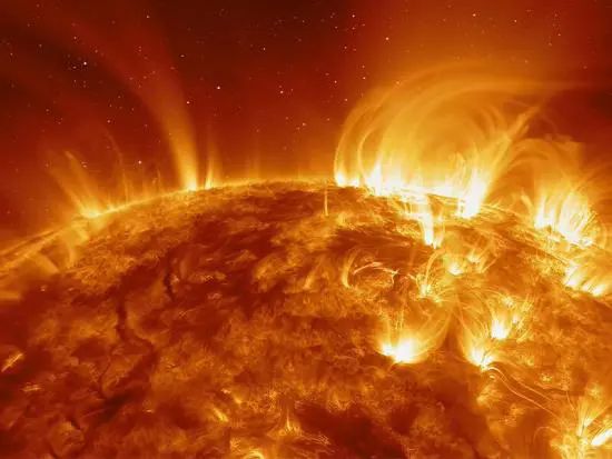
Solar flare storms, often referred to simply as solar storms, are captivating yet potentially hazardous phenomena that occur on the surface of the sun. These intense bursts of radiation and charged particles can have significant impacts on Earth’s magnetic field, telecommunications, and even power grids.

Key Takeaway:

  • Solar flares are sudden releases of energy on the Sun’s surface, emitting intense bursts of radiation.
  • These flares are categorized based on their intensity, ranging from A-class to X-class, with X-class flares being the most powerful.
  • Coronal mass ejections (CMEs) often accompany solar flares, releasing massive amounts of charged particles into space.
  • When CMEs collide with Earth’s magnetic field, they can cause geomagnetic storms, disrupting satellite communications, power grids, and navigation systems.
  • Space weather forecasting is essential for predicting and mitigating the impacts of solar flare storms on Earth.
  • Research and monitoring efforts are ongoing to enhance our understanding of solar activity and its potential effects on our planet.

Solar Flare Storm

Solar flare storms, though occurring millions of miles away on the surface of the Sun, have the potential to wreak havoc on Earth’s technology and infrastructure. These powerful bursts of energy can disrupt communication systems, interfere with power grids, and even pose risks to human health and space missions. Understanding the nature of solar flare storms, their causes, effects, and potential reduction strategies is essential for safeguarding our planet and reducing the impact of these cosmic events.

Understanding Solar Flares

Solar flares are sudden and intense eruptions of energy on the sun’s surface, typically near sunspots. These eruptions release vast amounts of electromagnetic radiation across the entire spectrum, from radio waves to gamma rays. The energy released during a solar flare can be equivalent to millions of atomic bombs exploding simultaneously.

Causes of Solar Flares

Solar flares are mainly triggered by the sudden release of magnetic energy stored in the Sun’s atmosphere. This energy is typically linked to the intricate interaction of magnetic fields near sunspots. When these magnetic fields become twisted and distorted, they can unleash immense amounts of energy in the shape of a solar flare.

Types of Solar Flares

Solar flares are classified into different categories based on their intensity and the wavelengths of radiation they emit. The classification system includes three main categories:

  1. X-Class Flares: These are the most intense solar flares, capable of causing widespread radio blackouts and long-lasting radiation storms.
  2. M-Class Flares: These flares are of moderate intensity and can lead to brief radio blackouts in the polar regions and minor radiation storms.
  3. C-Class Flares: These are the least intense solar flares, typically causing few noticeable effects on Earth.

Impact on Earth

Solar flares can have a range of effects on Earth’s magnetosphere and technological infrastructure. These effects can include:

  • Geomagnetic Storms: Solar flares can trigger geomagnetic storms when the charged particles they release interact with Earth’s magnetic field. These storms can disrupt satellite operations, power grids, and radio communications.
  • Auroras: Intense solar flares can produce stunning auroras, also known as the northern and southern lights. These colorful displays occur when charged particles from the sun collide with gases in Earth’s atmosphere, producing bright and colorful light shows near the polar regions.
  • Communication Disruptions: Solar flares can interfere with radio communications, especially those used for aviation and emergency services. This interference can range from minor static to complete signal loss, depending on the intensity of the flare and the frequency being used.

Reducing Risks

To reduce the risks associated with solar flare storms, scientists and engineers have developed various strategies and technologies:

  • Early Warning Systems: Satellites and ground-based observatories continuously monitor the sun for signs of solar activity, providing early warnings of impending solar flares.
  • Geomagnetic Storm Forecasting: Advanced modeling techniques allow scientists to forecast the intensity and impact of geomagnetic storms, enabling utilities and other critical infrastructure providers to take preventive measures.
  • Hardening Infrastructure: Power grids, satellites, and other critical infrastructure components can be hardened to withstand the effects of solar flares. This may include the use of shielding materials and redundant systems to minimize the risk of disruption.

Case Study: The Carrington Event

One of the most famous examples of a solar flare storm’s impact on Earth is the Carrington Event of 1859. Named after the British astronomer Richard Carrington, who observed the solar flare responsible for the event, the Carrington Event was a massive geomagnetic storm that caused widespread disruptions across the globe.

The Carrington Event produced auroras visible as far south as the Caribbean and caused telegraph systems to fail across Europe and North America. Telegraph operators reported receiving electric shocks, and some telegraph pylons caught fire due to the induced electrical currents. If a similar event were to occur today, the impacts could be far more severe due to our reliance on interconnected electrical and communication systems.

Table 1: Classification of Solar Flares

Class Peak Flux Range (Watts/m^2) Effects
X-Class Greater than 10^-4 Severe disruptions to radio signals
M-Class 10^-5 to 10^-4 Moderate radio blackouts
C-Class 10^-6 to 10^-5 Minor impact on radio communications

Table 2: Effects of Solar Flares on Earth

Impact Description
Geomagnetic Storms Disruption of power grids, satellite operations, and radio communications
Auroras Spectacular displays of light near the polar regions
Communication Disruptions Interference with radio communications, including aviation and emergency services

Hashtags:

#SolarFlare, #SpaceWeather, #GeomagneticStorm, #SunActivity, #SolarPhysics, #SpaceRadiation, #SpaceExploration, #SolarStormMitigation, #SpaceSafety, #SpaceTechnology

Rediscovered After 25 Years: US Satellite Lost and Found in Space

Key Takeaway

A small satellite called S73-7, launched in 1974 as part of a US Air Force mission, has been rediscovered after nearly 25 years of being untracked, thanks to the efforts of the 18th Space Defense Squadron.

Summary

  • S73-7, also known as the Infra-Red Calibration Balloon, was a 26-inch wide satellite launched in 1974 as a payload aboard the larger KH-9 Hexagon System satellite.
  • It was meant to inflate a balloon and continuously orbit the Earth at an altitude of 500 miles (805 km) to aid in the calibration of ground-based remote sensing equipment.
  • However, the satellite’s deployment failed, and it has periodically disappeared from radar tracking since the 1970s.
  • It went missing twice, first in the 1970s and then again in the 1990s, raising questions about how it could seemingly vanish from radar for so long.
  • Tracking satellites in low-Earth orbit can be challenging, especially if they do not transmit their identities and orbit near the equator, creating blind spots for radar systems.
  • After being untracked for nearly 25 years, S73-7 has been rediscovered and is currently being tracked again by the 18th Space Defense Squadron.
  • The rediscovery was announced on X (formerly Twitter) by astrophysicist Jonathan McDowell, who shared a graphic showing the satellite’s known locations since 1975.
  • The graphic reveals that S73-7 has been gradually losing altitude, dropping from its initial height of about 500 miles (805 km) to around 491 miles (790 km) today.
  • The satellite’s reappearance after such a long period highlights the challenges of tracking and monitoring the vast number of objects in Earth’s orbit, especially those that do not actively transmit their identities or locations.

The Rediscovery of a Lost Satellite

Launched in 1974 as part of a United States Air Force mission, the satellite known as S73-7, or the Infra-Red Calibration Balloon, was designed to inflate a balloon and continuously orbit the Earth at an altitude of approximately 500 miles (805 km). Its purpose was to aid in the calibration of ground-based remote sensing equipment, a crucial task for ensuring accurate data collection from space.

However, the satellite’s deployment did not go as planned, and it has periodically disappeared from radar tracking since the 1970s. This elusive behavior led to S73-7 being considered lost twice, first in the 1970s and then again in the 1990s, raising questions about how such an object could seemingly vanish from our tracking systems for extended periods.

After nearly 25 years of being untracked, S73-7 has now been rediscovered, thanks to the efforts of the 18th Space Defense Squadron. The rediscovery was announced on X (formerly Twitter) by astrophysicist Jonathan McDowell, who shared a graphic showing the satellite’s known locations since 1975.

The rediscovery of S73-7 highlights the significant challenges involved in tracking and monitoring the vast number of objects orbiting our planet. With over 20,000 cataloged pieces of debris, ranging from spent rocket stages to defunct satellites, the task of maintaining situational awareness in space is a daunting one.

One of the primary challenges is the fact that many of these objects do not actively transmit their identities or locations. This makes it difficult for ground-based radar systems to accurately track and identify them, especially when they orbit near the equator, creating blind spots for traditional tracking methods.

Additionally, the sheer number of objects in Earth’s orbit, coupled with their constant motion and potential for unexpected maneuvers, further complicates the tracking process. It’s akin to finding a needle in an intergalactic haystack, as Jonathan McDowell rightly described.

The rediscovery of S73-7 serves as a reminder of the critical importance of maintaining robust space situational awareness. As our reliance on space-based assets continues to grow, from communication satellites to weather monitoring systems, the need to accurately track and catalog debris becomes increasingly crucial.

Untracked debris poses a significant threat to operational spacecraft, as even a small piece of debris traveling at high speeds can cause catastrophic damage. This risk underscores the need for improved tracking mechanisms and international cooperation to ensure the sustainable use of the space domain.

Furthermore, the ability to track and monitor space debris is not just about mitigating immediate risks; it also plays a vital role in enabling future space exploration and utilization. As we look towards ambitious goals such as establishing a sustained human presence on the Moon and eventually exploring Mars, a comprehensive understanding of the space environment and the ability to navigate through it safely will be paramount.

Addressing the challenges of space debris tracking and maintaining situational awareness in space will require a multifaceted approach involving technological advancements, international collaboration, and a commitment to responsible space stewardship.

One potential solution lies in the development of advanced tracking systems that can more accurately detect and identify objects, even those that do not actively transmit signals. This could involve the use of advanced radar systems, optical telescopes, and even space-based sensors to provide a more comprehensive picture of the space environment.

Additionally, international cooperation and data sharing among space agencies and private entities will be crucial in creating a unified, global space situational awareness network. By pooling resources and sharing information, we can improve our collective understanding of the space domain and better coordinate efforts to mitigate risks.

Finally, a renewed emphasis on responsible space stewardship is essential. This includes implementing measures to minimize the creation of new debris, such as designing spacecraft with end-of-life disposal plans and adhering to best practices for mitigating the risk of collisions.

The rediscovery of S73-7 serves as a touching reminder of the challenges we face in maintaining situational awareness in the increasingly congested space domain. While the satellite’s reappearance is a testament to the dedication and perseverance of those involved in space debris tracking, it also highlights the pressing need for enhanced tracking mechanisms and a concerted effort to address the growing issue of space debris.

As we continue to explore and utilize the vast expanse of space, it is imperative that we prioritize the development of robust tracking systems, foster international collaboration, and promote responsible space stewardship. Only by addressing these challenges head-on can we ensure the sustainable and safe use of the space domain for generations to come.

HASHTAGS:

#SpaceDebris, #SpaceSituationalAwareness, #SatelliteTracking, #S73-7, #SpaceExploration, #SpaceSustainability, #SpaceSafety, #SpaceTechnology, #InternationalCollaboration, #ResponsibleSpaceStewardship #US Satellite Lost and Found
Pin It
error: Content is protected !!

On this website we use first or third-party tools that store small files (<i>cookie</i>) on your device. Cookies are normally used to allow the site to run properly (<i>technical cookies</i>), to generate navigation usage reports (<i>statistics cookies</i>) and to suitable advertise our services/products (<i>profiling cookies</i>). We can directly use technical cookies, but <u>you have the right to choose whether or not to enable statistical and profiling cookies</u>. <b>Enabling these cookies, you help us to offer you a better experience</b>.