Tag

#PlanetaryScience

Browsing

NASA’s Suborbital Rocket Confirms Global Electric Field Existence

NASA’s suborbital rocket mission, Endurance, has confirmed the existence of the ambipolar electric field, a global electric field hypothesized over 60 years ago. This discovery, made through precise measurements taken during a flight in the Arctic, provides significant insights into the behavior of Earth’s atmosphere, particularly regarding the phenomenon known as the polar wind. These findings have profound implications for our understanding of Earth’s atmospheric escape mechanisms and may also aid in exploring the atmospheres of other planets.

Summary

  • Discovery: NASA’s Endurance mission confirmed the existence of the ambipolar electric field, a global electric field that influences Earth’s upper atmosphere.
  • Significance: This field was first hypothesized over 60 years ago but had never been measured until now.
  • Polar Wind: The ambipolar field helps explain the polar wind, a stream of particles escaping Earth’s atmosphere at supersonic speeds.
  • Technological Breakthrough: The development of new instruments enabled the detection of this weak field, which was previously beyond the capabilities of existing technology.
  • Arctic Launch: The mission was launched from Svalbard, Norway, the only site where the required measurements could be taken.
  • Measurement Details: The rocket recorded a change in electric potential of just 0.55 volts across a distance of 518 km.
  • Impact on Particles: The ambipolar field exerts a force on hydrogen ions that is 10.6 times stronger than gravity, propelling them into space at supersonic speeds.
  • Broader Implications: Understanding the ambipolar field aids in unraveling Earth’s atmospheric history and could inform studies of other planetary atmospheres.
  • Published Findings: The research has been published in the scientific journal Nature.
  • Global and Planetary Relevance: This discovery not only deepens our understanding of Earth’s atmosphere but also provides insights into the atmospheres of other planets and their potential habitability.
NASA’s Suborbital Rocket Confirms Global Electric Field Existence
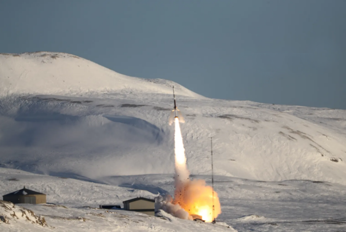
Endurance launches from Ny-Ålesund, Svalbard.
Credit: NASA/Brian Bonsteel

The Existence of a Global Electric Field Confirmed: Insights from NASA’s Endurance Mission

For decades, the concept of a global electric field known as the ambipolar electric field remained a hypothesis. Scientists speculated that such a field could play a crucial role in atmospheric escape, particularly at Earth’s poles. However, due to the field’s extremely weak nature, detecting it was beyond the reach of available technology. This changed with NASA’s Endurance mission, which successfully measured this elusive field, providing a breakthrough in our understanding of Earth’s upper atmosphere.

The polar wind, first detected in the late 1960s, has puzzled scientists for over half a century. This stream of particles, escaping from Earth’s atmosphere into space, defied expectations. While it was anticipated that intense sunlight would drive some atmospheric outflow, the polar wind was different. Many of the particles within it were cold and unheated, yet they moved at supersonic speeds. The question of what was propelling these particles remained unanswered until the recent findings from the Endurance mission.

Glyn Collinson, the principal investigator of the Endurance mission, along with his team, hypothesized that an electric field could be responsible for the polar wind. This field, they believed, was generated at the subatomic level and extended over hundreds of miles. However, detecting such a weak field required technological advancements that did not exist until recently.

In 2016, Collinson and his team began developing a specialized instrument capable of measuring the ambipolar electric field. This instrument was designed for a suborbital rocket flight, which would allow it to travel through the Earth’s upper atmosphere and capture the necessary data. The mission was aptly named Endurance, in honor of Ernest Shackleton’s 1914 Antarctic expedition.

The team selected Svalbard, a Norwegian archipelago near the North Pole, as the launch site for the Endurance mission. This location is home to the world’s northernmost rocket range, making it ideal for studying the polar wind. The suborbital rocket was launched on May 11, 2022, and reached an altitude of 768 km before splashing down in the Greenland Sea after a 19-minute flight.

During its flight, the Endurance rocket recorded a change in electric potential of only 0.55 volts across a range of 518 km. While this may seem like a minuscule amount—about as strong as a watch battery—it was enough to confirm the existence of the ambipolar electric field.

The measurements from the Endurance mission revealed that the ambipolar electric field exerts a force on hydrogen ions, the most abundant particles in the polar wind, that is 10.6 times stronger than gravity. This force is sufficient to propel these particles into space at supersonic speeds. Heavier particles, such as oxygen ions, also experience a significant boost from the field, effectively reducing their weight at high altitudes.

The discovery of the ambipolar electric field has far-reaching implications beyond just understanding the polar wind. It provides valuable insights into the complex processes that govern atmospheric escape and the evolution of Earth’s atmosphere. Moreover, this knowledge could be instrumental in studying the atmospheres of other planets, helping scientists determine their potential habitability.

The Significance of the Findings

The findings from the Endurance mission have been published in the esteemed scientific journal, Nature. This research marks a significant milestone in atmospheric science, confirming a hypothesis that has persisted for over 60 years. The study of the ambipolar electric field not only enhances our understanding of Earth’s atmosphere but also opens new avenues for exploring other planetary environments.

Comparative Table of Earth’s Atmosphere vs. Other Planets

Aspect Earth Mars Venus
Atmosphere Composition Nitrogen (78%), Oxygen (21%), Argon (0.9%) Carbon Dioxide (95.3%), Nitrogen (2.7%) Carbon Dioxide (96.5%), Nitrogen (3.5%)
Atmospheric Pressure 101.3 kPa 0.6 kPa 93 kPa
Surface Temperature 15°C (average) -63°C (average) 462°C (average)
Escape Velocity 11.2 km/s 5.0 km/s 10.4 km/s
Presence of Ambipolar Field Confirmed Hypothesized Hypothesized

The successful detection of the ambipolar electric field is a testament to the advancements in technology over the past few decades. The instruments developed for the Endurance mission were specifically designed to measure weak electric fields at the subatomic level. These technological innovations have not only allowed us to confirm the existence of the ambipolar field but also to understand its effects on atmospheric particles in unprecedented detail.

Despite the success of the Endurance mission, there are still many unanswered questions about the ambipolar electric field and its role in Earth’s atmosphere. Future research will likely focus on understanding how this field interacts with other atmospheric processes and how it may vary across different regions and seasons. Additionally, scientists are interested in exploring whether similar fields exist on other planets and how they might influence atmospheric escape in those environments.

The discovery of the ambipolar electric field has significant implications for interplanetary exploration. Understanding how this field drives atmospheric escape on Earth could provide clues about similar processes on other planets. For example, studying the atmospheres of Mars and Venus could reveal whether they have their own ambipolar fields and how these fields might affect the potential for life on these planets.

Second Table: Ambipolar Electric Field vs. Other Known Electric Fields

Electric Field Type Strength (Volts) Scale (Distance) Primary Influence
Ambipolar Electric Field 0.55 volts 518 km Drives atmospheric escape at poles
Atmospheric Electric Field 100-300 volts/meter Earth’s surface to ionosphere Influences weather patterns
Solar Wind Electric Field 10 mV/km 1 AU (Astronomical Unit) Affects planetary magnetospheres
Thunderstorm Electric Field 10-30 kV/meter Localized (clouds to ground) Triggers lightning strikes

Sources:

#NASA, #EnduranceMission, #AmbipolarElectricField, #AtmosphericScience, #PolarWind, #SpaceExploration, #ElectricFields, #PlanetaryScience, #EarthAtmosphere, #ScientificDiscovery

NASA’s Mars Rover Perseverance Takes on Steep Crater Rim Climb

Key Takeaways

  • Perseverance Rover’s New Challenge: NASA’s Perseverance rover begins a steep climb up the Jezero Crater rim, marking a significant milestone in its mission.
  • Mission Objectives: The rover aims to collect rock samples from the crater’s rim, potentially uncovering clues about Mars’ ancient climate and the possibility of past life.
  • Scientific Importance: The rock samples could help scientists understand how rocky planets like Mars and Earth formed and evolved.
  • Technical Challenges: The climb involves navigating rocky terrain with slopes of up to 23 degrees, showcasing the rover’s robust engineering.
  • Broader Implications: The findings could provide insights into early planetary environments and the origins of life, both on Mars and Earth.

Summary

  • Objective: Perseverance’s climb to Jezero Crater’s rim is part of its mission to collect rock samples.
  • Significance: The rock samples may reveal details about ancient Martian life and the planet’s climate billions of years ago.
  • Challenge: The rover faces a difficult climb, with slopes reaching 23 degrees.
  • Previous Achievements: Since landing in 2021, Perseverance has collected 22 rock core samples from the crater floor.
  • Scientific Potential: The bedrock at the crater’s rim could offer new insights into the formation of rocky planets.
  • Technical Details: The rover has logged approximately 29 kilometers during its exploration.
  • Geological Interest: The crater’s rim may contain rocks from past hydrothermal vents, similar to those on Earth where life is thought to have originated.
  • Future Prospects: NASA is exploring ways to bring these rock samples back to Earth for further study.
  • Historical Context: This mission is a continuation of humanity’s quest to explore Mars and uncover its secrets.

NASA’s Perseverance Rover: Conquering the Jezero Crater Rim

NASA’s Perseverance rover, a key player in humanity’s exploration of Mars, has embarked on a bold new chapter of its mission. After spending three and a half years at the bottom of Jezero Crater, the six-wheeled rover has begun an ambitious climb toward the crater’s rim. This climb, which started on August 27, 2024, is not just a test of Perseverance’s engineering; it’s a crucial step in the search for ancient Martian life.

Perseverance landed on Mars in February 2021, touching down in Jezero Crater, a site of great scientific interest. Billions of years ago, this crater was filled with water, making it a prime location to search for signs of ancient life. Over the past three and a half years, Perseverance has methodically explored the crater floor, collecting 22 rock core samples. These samples are now waiting for a future mission that will bring them back to Earth for detailed analysis.

“Perseverance has certainly been a real trooper,” said Steven Lee of NASA’s Jet Propulsion Laboratory (JPL) in California. The rover has logged approximately 29 kilometers since its landing, all while enduring the harsh Martian environment.

Now, Perseverance faces a new challenge: climbing the steep, rocky terrain of Jezero Crater’s rim. The ascent is no small feat, with slopes reaching up to 23 degrees. The rover will need to navigate these inclines carefully, using its six-wheel-drive system and advanced autonomous navigation capabilities.

Table 1: Perseverance Rover Specifications

Feature Specification
Launch Date July 30, 2020
Landing Date February 18, 2021
Landing Site Jezero Crater, Mars
Mission Duration Planned for at least one Martian year (687 Earth days)
Distance Covered (as of Aug 2024) 29 kilometers
Main Mission Objectives Search for signs of ancient life, collect rock and soil samples, test new technology for future Mars missions

The climb is expected to take several months, during which Perseverance will continue to collect data and images. The primary goal of this ascent is to reach the bedrock at the top of the crater, which may contain rocks from ancient hydrothermal vents. These vents, where heated water and dissolved minerals once spewed out from beneath the planet’s surface, are of particular interest to scientists. On Earth, similar environments, such as those in Yellowstone National Park, are considered potential cradles of life.

The samples collected from the crater’s rim could provide critical insights into Mars’ geological history. Scientists believe that studying these rocks will help them piece together the story of how rocky planets like Mars and Earth formed and evolved over billions of years.

Table 2: Key Findings from Perseverance’s Mission

Discovery Description
Ancient River Delta Evidence Perseverance discovered an ancient river delta in Jezero Crater, indicating the presence of water billions of years ago.
Organic Molecules Detected The rover found organic molecules in rock samples, suggesting the potential for ancient life.
First Oxygen Production on Mars Perseverance successfully produced oxygen from Mars’ carbon dioxide-rich atmosphere using the MOXIE instrument.
High-Resolution Images The rover has captured thousands of high-resolution images, providing unprecedented views of the Martian surface.

One of the key questions that Perseverance seeks to answer is whether Mars ever supported life. The presence of water in Jezero Crater suggests that the conditions may have been right for life to exist billions of years ago. By studying the rock samples collected during this mission, scientists hope to find evidence of ancient microbial life or, at the very least, clues about the planet’s past climate.

“The bedrock at the rim of Jezero Crater might yield clues as to how rocky planets like Mars and Earth came to be,” said Lee. This statement underscores the broader significance of Perseverance’s mission, which extends beyond Mars to our understanding of planetary science as a whole.

The success of Perseverance’s mission is a testament to the ingenuity and dedication of the engineers and scientists at NASA’s JPL. The rover was designed to withstand the harsh conditions of Mars, from extreme temperatures to dust storms. Its sophisticated instruments and durable construction enable it to carry out complex scientific tasks in a challenging environment.

Perseverance is equipped with a suite of scientific instruments designed to analyze the Martian surface and atmosphere. These include:

  • Mastcam-Z: A pair of zoomable cameras that capture high-resolution images and 3D panoramas.
  • SuperCam: A versatile instrument that uses lasers to study the composition of rocks and soil from a distance.
  • PIXL (Planetary Instrument for X-ray Lithochemistry): An X-ray fluorescence spectrometer that can detect the chemical elements in rocks and soil.
  • RIMFAX (Radar Imager for Mars’ Subsurface Experiment): A ground-penetrating radar that provides a view of what lies beneath the Martian surface.

These instruments, combined with Perseverance’s robust mobility system, allow the rover to conduct a wide range of scientific experiments as it explores Mars.

Perseverance and the Search for Life

One of the most exciting aspects of Perseverance’s mission is its potential to find signs of past life on Mars. While no definitive evidence of life has been found yet, the rover’s discoveries have fueled hope among scientists.

In particular, the detection of organic molecules in rock samples has been a significant finding. Organic molecules are the building blocks of life, and their presence on Mars suggests that the planet may have once had conditions suitable for life.

Perseverance’s search for life is not limited to the surface. The rover is also equipped to drill into the Martian soil and collect subsurface samples. These samples could reveal additional clues about the planet’s history and its potential to harbor life.

One of the most ambitious goals of Perseverance’s mission is to collect rock and soil samples that can be returned to Earth. NASA is currently working on plans for a future mission that will retrieve these samples and bring them back for detailed analysis.

This sample return mission, if successful, would be a major milestone in the exploration of Mars. It would allow scientists to study Martian rocks and soil in ways that are not possible with remote instruments. The data obtained from these samples could revolutionize our understanding of Mars and its potential for life.

#MarsExploration, #PerseveranceRover, #NASA, #Mars2024, #JezeroCrater, #MartianLife, #SpaceScience, #PlanetaryScience

New Geological Connection Between Earth and Venus Discovered by Scientists

Scientists have discovered a surprising geological connection between Earth and Venus, suggesting that despite the absence of plate tectonics on Venus, the planet may have experienced similar geological processes as Earth. This discovery opens new avenues for understanding planetary evolution and raises questions about Venus’s past habitability.

Summary

  • Venus is often called Earth’s “sister planet” due to their similarities in size, mass, and composition.
  • Unlike Earth, Venus lacks plate tectonics, traditionally believed to be essential for significant geological activity.
  • New research suggests that Venus’s Ishtar Terra, a highland region, may have formed through processes similar to those that created Earth’s ancient cratons.
  • Cratons are the stable, ancient cores of continents on Earth, some dating back over 2.5 billion years.
  • The discovery challenges previous assumptions about Venus’s geological history, indicating that the planet may have been more geologically active in the past.
  • This finding raises questions about the potential for past habitability on Venus and the role of similar geological processes in planetary evolution.
  • Understanding Venus’s geological history is crucial for comparative planetology and could provide insights into Earth’s own evolution.
  • Future missions to Venus should focus on gathering more data about its geology, atmosphere, and potential for past habitability.
  • The study highlights the need for continued exploration of Venus to unlock the secrets of its past and its implications for planetary science.

Venus: Earth’s Geological Twin?

Venus has long fascinated scientists due to its many similarities with Earth. Both planets are similar in size, mass, and composition, earning Venus the nickname “Earth’s sister planet.” However, the two planets have changed a lot in their geological and atmospheric development. Earth is a dynamic planet. It has active plate tectonics, which means its surface is made up of large plates that move and cause earthquakes. Venus, on the other hand, has been considered inactive for a long time. New research has found a surprising connection between the geology of Earth and Venus. This discovery challenges what we thought we knew about Venus’s history and how it relates to Earth.

Venus and Earth

Venus and Earth look very similar at first. Both are called terrestrial planets. This means they are mostly made of rock and metal. Both planets have thick atmospheres filled with carbon dioxide. They are also similar in size and density. This means they have almost the same amount of mass and take up nearly the same amount of space. However, Venus and Earth have evolved in very different ways.

Earth is a lively and ever-changing planet. Its surface changes all the time due to plate tectonics. In plate tectonics, the outer shell of the Earth, known as the lithosphere, is made up of large pieces called plates. These plates move and interact with each other. This movement forms continents, mountains, and oceans. It also creates many different geological features. Plate tectonics are very important in controlling Earth’s climate. They help create the right conditions for life to exist.

Venus, on the other hand, is very different. Thick clouds of sulfuric acid cover the planet’s surface. The atmospheric pressure is extremely high, more than 90 times that of Earth’s. Surface temperatures on Venus reach a blistering 900 degrees Fahrenheit (475 degrees Celsius). This heat is hot enough to melt lead. Because of these extreme conditions, scientists see Venus as a hostile place. They believe it has little or no tectonic activity, which means the planet’s surface does not change much through movements of the crust.

Ishtar Terra

Recent research has cast doubt on the long-held belief that Venus is a geologically dead planet. A team of scientists has focused their attention on Ishtar Terra, one of the planet’s three major highland regions. Ishtar Terra, located near Venus’s north pole, is a vast plateau that includes some of the planet’s most prominent geological features, including the Maxwell Montes mountain range, which rises nearly 11 kilometers (6.8 miles) above the surrounding plains.

Ishtar Terra’s topography is strikingly similar to Earth’s highland regions, such as the Tibetan Plateau. This similarity has led scientists to wonder whether Ishtar Terra may have formed through processes analogous to those that shaped Earth’s ancient cratons. Cratons are the ancient, stable cores of continents on Earth, some of which date back over 2.5 billion years. These geological formations are among the oldest rocks on our planet and provide crucial insights into Earth’s early history.

The recent study, published in the journal Nature Geoscience, used advanced computer simulations and data from NASA’s Magellan spacecraft to explore the formation of Ishtar Terra. The researchers discovered that the highland region may have been formed by processes similar to those that created Earth’s cratons. Specifically, they found evidence that powerful upwellings of molten rock from Venus’s interior could have caused the crust to thicken and rise, creating a plateau-like structure.

This finding is surprising because it suggests that Venus, despite lacking plate tectonics, may have experienced similar geological processes as Earth. The absence of plate tectonics on Venus has long been thought to limit the planet’s ability to generate significant geological features. However, the discovery of a thick, craton-like crust in Ishtar Terra challenges this assumption and opens new possibilities for understanding Venus’s geological history.

New Geological Connection Between Earth and Venus Discovered by Scientists
Click on the image to explore a 3D map of Ishtar Terra. This map is interactive, meaning you can click and move around it. It is available on Sketchfab, a website for sharing 3D content. The user who created this map goes by the name v7x. Image Credit: Sketchfab/v7x

Implications for Planetary Evolution

The implications of this discovery are profound. If Venus did indeed experience a period of intense geological activity, it raises important questions about the planet’s past. For example, could Venus have once had conditions similar to early Earth, including the presence of oceans and a more temperate climate? If so, what caused Venus to undergo such a dramatic transformation into the inhospitable world we see today?

Understanding what led to Venus’s current state is important. It helps us learn about how planets change over time. This knowledge is also useful when studying exoplanets, which are planets outside our solar system. Scientists want to know what makes a planet habitable, or able to support life. Venus might have important hints about how Earth developed early on. It could also show us the potential for life on other planets.

The Role of Ishtar Terra in Venus’s Geological History

To better understand the significance of Ishtar Terra, it’s essential to examine the region’s geological features in more detail. Ishtar Terra is divided into several distinct regions, each with its own unique characteristics. These include the Maxwell Montes mountain range, the Lakshmi Planum plateau, and the surrounding plains.

Maxwell Montes

Maxwell Montes is the highest mountain range on Venus, rising to an elevation of nearly 11 kilometers (6.8 miles) above the surrounding terrain. The range is composed of heavily deformed rocks, indicating a complex geological history. The presence of Maxwell Montes within Ishtar Terra suggests that the region has experienced significant tectonic forces, despite the lack of plate tectonics on Venus.

Lakshmi Planum

Lakshmi Planum is a vast, elevated plateau within Ishtar Terra, covering an area of approximately 2 million square kilometers. The plateau is characterized by smooth lava flows, indicating a history of volcanic activity. Two large shield volcanoes, Colette and Sacajawea, are also located within Lakshmi Planum. These features further suggest that Ishtar Terra has been shaped by processes similar to those that formed Earth’s cratons.

The Plains

Surrounding Ishtar Terra are vast plains, which are relatively smooth and featureless compared to the highland regions. These plains are likely the result of extensive lava flows, which have covered much of Venus’s surface over time. The transition from the highland regions to the plains provides clues about the geological processes that have shaped Venus’s surface.

Comparing Earth and Venus: Cratons and Highlands

To better understand the connection between Earth and Venus, it’s helpful to compare the geological features of the two planets. On Earth, cratons are the ancient cores of continents, and they are typically found in the center of tectonic plates. These cratons are composed of some of the oldest rocks on the planet and provide valuable insights into Earth’s early history.

Cratons are characterized by their stability and resistance to tectonic forces. They are composed of thick, rigid lithosphere, which helps them withstand the forces that reshape other parts of the Earth’s crust. This stability allows cratons to preserve a record of geological processes that occurred billions of years ago.

The discovery of a craton-like structure in Ishtar Terra suggests that Venus may have experienced similar geological processes in its past. The thick, stable crust of Ishtar Terra could be the result of upwellings of molten rock from Venus’s interior, similar to the processes that formed Earth’s cratons. This finding challenges the long-held assumption that plate tectonics are necessary for significant geological activity and suggests that other processes may be at work on Venus.

Venus’s Lithosphere

One of the key differences between Earth and Venus is the thickness of their lithospheres. Earth’s lithosphere can be as thick as 200 kilometers (124 miles) in some regions, while Venus’s lithosphere is much thinner, estimated to be between 50 and 100 kilometers (31 to 62 miles) thick. This thinner lithosphere may have significant implications for the planet’s geological history.

The thin outer layer of Venus, called the lithosphere, is likely more prone to bending and breaking than Earth’s thicker outer layer. This could be why we see large volcanic features on Venus. For example, there are shield volcanoes in an area called Lakshmi Planum. The surface of Venus is also covered with extensive lava flows. This thin lithosphere suggests that Venus has likely gone through intense periods of geological activity in the past. This happened even though it doesn’t have the same plate movement as Earth.

The Role of Volcanism in Venus’s Geological History

Volcanism has significantly shaped Venus’s surface. Large shield volcanoes are spread across the planet. Some of these volcanoes are among the largest in the solar system. Shield volcanoes have broad, gently sloping shapes. This shape is created by the eruption of lava that flows easily.

The presence of shield volcanoes in Ishtar Terra suggests that the region has been shaped by volcanic activity. This is further supported by the smooth lava flows that characterize Lakshmi Planum. The discovery of a craton-like structure in Ishtar Terra, combined with evidence of extensive volcanism, suggests that Venus’s geological history may be more complicated than previously thought.

Comparative Planetology: Lessons from Venus

The discovery of a geological connection between Earth and Venus has significant implications for the field of comparative planetology. Comparative planetology is the study of planets by comparing their characteristics and evolution. By studying the similarities and differences between planets, scientists can gain insights into the processes that shape planetary systems.

Venus and Earth provide a unique opportunity for comparative planetology. Despite their many similarities, the two planets have followed dramatically different evolutionary paths. Understanding why this divergence occurred could provide valuable insights into the factors that influence planetary evolution.

The Search for Past Habitability on Venus

One of the most intriguing questions raised by the discovery of a geological connection between Earth and Venus is the possibility of past habitability on Venus. If Venus once had conditions similar to early Earth, including the presence of liquid water, it raises the possibility that the planet could have supported life in its distant past.

Recent studies have suggested that Venus may have had a more temperate climate in its early history, with liquid water oceans that persisted for billions of years. If true, this would make Venus one of the most Earth-like planets in the solar system. However, at some point in its history, Venus underwent a dramatic transformation, leading to the extreme conditions we see today.

Understanding the factors that led to Venus’s current state is crucial for assessing the planet’s potential for past habitability. The discovery of a craton-like structure in Ishtar Terra suggests that Venus may have experienced similar geological processes as Earth, which could have played a role in the planet’s early climate and habitability.

Future Exploration of Venus

The discovery that Earth and Venus have a geological connection shows we need to explore Venus more. Venus is our closest neighbor planet, but we still know very little about it. It is one of the least explored planets in the solar system. The planet’s surface has very harsh conditions. These tough conditions make it hard to collect detailed information about its rocks, air, and history.

Future missions to Venus, such as NASA’s VERITAS mission and the European Space Agency’s EnVision mission, aim to address these challenges by providing high-resolution data about the planet’s surface and subsurface. These missions will help scientists better understand the geological processes that have shaped Venus and provide crucial insights into its past habitability.

The discovery of a new geological connection between Earth and Venus challenges our understanding of the two planets and their divergent evolutionary paths. Despite the absence of plate tectonics on Venus, the planet may have experienced similar geological processes as Earth, leading to the formation of craton-like structures in Ishtar Terra. This finding raises important questions about Venus’s past habitability and the factors that shaped its current state.

Hashtags

#Venus, #Geology, #PlanetaryScience, #Cratons, #IshtarTerra, #NASA, #SpaceExploration, #ComparativePlanetology, #Volcanism, #Habitability

Terraforming Mars with Tiny Metal Rods: The Future of Making the Red Planet Habitable

  • Terraforming Mars involves altering its environment to make it more suitable for Earth-like life.
  • A new method proposes using glitter-sized iron and aluminum rods to increase the planet’s temperature by around 30°C.
  • Micro-metal rods can be mined from Mars itself, reducing the need to import materials from Earth.
  • The concept is 5000 times more efficient than other proposed methods like engineered greenhouse gases.
  • Ethical concerns arise around altering another planet’s atmosphere, especially given our limited knowledge of Mars’ deep surface.

Summary

  • Terraforming is the process of modifying a planet’s environment to make it more Earth-like.
  • Mars currently has an average surface temperature of -65°C, making it inhospitable for Earth-like life.
  • Previous proposals for warming Mars included space mirrors and methane pumping, but these were resource-intensive.
  • New research by Edwin Kite and colleagues suggests that small iron and aluminum rods could be more efficient.
  • These rods are 9 micrometers long and 160 nanometers wide, capable of trapping heat in Mars’ atmosphere.
  • Warming effect could raise Mars’ temperature by 30°C, potentially allowing liquid water and supporting microbial life.
  • Required materials could be mined directly on Mars, significantly reducing logistical challenges.
  • The method would require releasing 700,000 cubic meters of metal per year, equal to 1% of Earth’s annual metal production.
  • One challenge is understanding how these rods interact with water in Mars’ atmosphere, which could impact the warming process.
  • Ethical considerations include the impact of altering Mars’ atmosphere and whether we should terraform a planet with an unexplored deep surface.
Terraforming Mars with Tiny Metal Rods The Future of Making the Red Planet Habitable
New space rocket shuttle successfully takes off into space with the red planet Mars and the blue planet Earth with rays of sunlight. Space Mission. Success Launch Start Up concept

Terraforming Mars with Tiny Metal Rods

Terraforming, the concept of transforming a planet’s environment to resemble Earth’s, has long been a subject of fascination and debate. Mars, our neighboring Red Planet, is the prime candidate for such an undertake. However, the challenges are enormous, given its harsh environment with temperatures averaging -65°C (-85°F). Scientists have proposed various methods to warm Mars, making it more hospitable for life, but most of these methods are resource-intensive and difficult to implement.

A recent study led by Edwin Kite at the University of Chicago presents a novel approach to this problem: using tiny rods of iron and aluminum to warm Mars. This method could be a game-changer in the field of planetary engineering, offering a more efficient and feasible way to terraform Mars.

The Science Behind Terraforming Mars

Mars is a cold, barren planet with a thin atmosphere composed mostly of carbon dioxide. Its surface temperature ranges from -140°C (-220°F) during winter at the poles to 20°C (70°F) during summer at the equator, but the average temperature is a frigid -65°C. The thin atmosphere means that even if the surface heats up during the day, the heat quickly escapes at night.

The idea of terraforming Mars revolves around changing these conditions to create a more Earth-like environment, capable of supporting life. The key challenge is raising the planet’s temperature and atmospheric pressure to allow liquid water to exist, a fundamental requirement for life as we know it.

Previous Proposals

Several ideas have been floated over the years to warm Mars:

  1. Space Mirrors: Large mirrors in space could reflect sunlight onto Mars’ surface, increasing the temperature. However, the logistics and costs involved in building and deploying such mirrors are staggering.
  2. Greenhouse Gases: Pumping greenhouse gases like methane into Mars’ atmosphere could trap more heat. But this method would require massive amounts of methane, which would need to be transported from Earth or synthesized on Mars, both of which are currently impractical.
  3. Nuclear Explosions: Another radical idea involves using nuclear explosions to heat Mars’ poles, releasing trapped CO2 and thickening the atmosphere. This idea is controversial, not least because of the potential dangers and ethical concerns.

Each of these methods has significant drawbacks, making the search for a more efficient solution critical.

The New Approach: Tiny Metal Rods

Edwin Kite and his team propose a new method that could be much more practical and efficient. The idea is to release tiny rods of iron or aluminum, each about 9 micrometers long and 160 nanometers wide, into Mars’ atmosphere. These rods would be mined from Mars’ surface, eliminating the need to transport materials from Earth.

Once released, these rods would be carried by wind into the upper atmosphere, where they would remain for about a decade. Their small size allows them to trap heat effectively, while still allowing sunlight to pass through. The trapped heat would raise the planet’s surface temperature by about 30°C, enough to melt ice and support microbial life.

Kite and his colleagues used climate models to simulate the effects of releasing these rods. Their results showed that the rods could increase the temperature by about 30°C in a matter of months to a decade, depending on how quickly the particles are dispersed. This increase in temperature would also lead to a rise in atmospheric pressure, potentially allowing liquid water to exist on the surface.

The warming effect is critical because it could create conditions suitable for microbial life. Microbes could play a vital role in terraforming Mars, as some bacteria are capable of producing oxygen, further transforming the planet’s atmosphere over time.

Terraforming Mars with Tiny Metal Rods The Future of Making the Red Planet Habitable

Practical Considerations

One of the biggest challenges in terraforming Mars is the sheer amount of material required. However, Kite’s approach is surprisingly efficient. To achieve the necessary warming, only about 700,000 cubic meters of metal rods would need to be released each year. This is equivalent to just 1% of Earth’s total annual metal production, making it a feasible target.

The fact that these materials could be mined directly on Mars is another significant advantage. This reduces the logistical challenges and costs associated with transporting materials from Earth. However, mining on Mars is not without its challenges, and significant technological advancements would be needed to extract and process these metals on the planet.

One of the uncertainties in this method is how the tiny rods would interact with Mars’ atmosphere, particularly with water vapor. There is a possibility that water molecules could cling to the rods, causing them to fall back to the surface as rain. This would reduce the warming effect, as the rods would no longer be in the atmosphere to trap heat.

This interaction needs to be carefully studied, as it could impact the overall effectiveness of the terraforming process. If the rods do indeed fall out of the atmosphere too quickly, alternative strategies might be needed, such as continuously replenishing the rods or finding ways to prevent water from clumping around them.

Ethical Considerations

While the idea of terraforming Mars is exciting, it raises important ethical questions. Mars is a pristine environment, and we know very little about its deep surface and potential for existing life forms. By altering its atmosphere, we could be destroying any chance of discovering native Martian life.

There is also the issue of planetary protection. International agreements currently require that we avoid contaminating other planets with Earth life. Terraforming Mars would almost certainly violate these agreements, as it would involve introducing Earth-based microbes and potentially altering the planet’s environment irreversibly.

Conclusion

Terraforming Mars is one of the most ambitious ideas in human history. It involves changing the planet’s harsh environment to make it more like Earth. The idea of turning a barren, frozen world into a second Earth is exciting. However, it is also very challenging. One new proposal is to use tiny metal rods to warm Mars. This approach seems promising and could help make the dream of terraforming Mars come true.

However, before we can proceed, we must carefully consider the ethical implications and ensure that we are not causing irreversible harm to a planet we are only just beginning to understand. With careful planning, international collaboration, and ongoing research, terraforming Mars could one day become a reality, offering a new frontier for human exploration and habitation.

Sources:

  1. Science Advances DOI: 10.1126/sciadv.adn4650: https://dx.doi.org/10.1126/sciadv.adn4650
  2. Manoj Joshi, University of East Anglia: https://research-portal.uea.ac.uk/en/persons/manoj-joshi
  3. Edwin Kite, University of Chicago: https://geosci.uchicago.edu/people/edwin-kite/
  4. Space mirrors for terraforming: https://www.newscientist.com/article/dn10573-space-mirrors-could-create-earth-like-haven-on-mars/
  5. Terraforming Mars and carbon dioxide: https://www.newscientist.com/article/2175414-terraforming-mars-might-be-impossible-due-to-a-lack-of-carbon-dioxide/

Hashtags

#TerraformingMars, #MarsExploration, #PlanetaryScience, #SpaceExploration, #MarsTerraforming, #SpaceScience, #FutureOfSpace, #Astrobiology

The Science Behind Meteorites Striking the Surface of Mars Daily

Key Takeaway

Meteorites strike the surface of Mars daily, with NASA’s InSight lander and its SEIS instrument providing critical data to understand these impacts. This data has allowed scientists to estimate impact rates, revealing insights into the geological history and potential hazards for future missions.

Summary

  • NASA’s InSight Mars Lander’s SEIS instrument collected seismic data on Mars for over four years.
  • Researchers used this data to determine a new meteorite impact rate for Mars.
  • SEIS detected over 1300 seismic events, with a portion attributed to meteorite impacts.
  • Scientists estimate that 280 to 360 meteoroids, about the size of basketballs, strike Mars each year.
  • This rate is five times higher than previously estimated from orbital imagery.
  • Impact rates help understand the age of Mars’ surface and provide insight into its geological history.
  • The study shows that seismometers are reliable tools for measuring impact rates on Mars.
  • The data has broader implications for understanding impact rates throughout the Solar System.
  • Frequent impacts create significant blast zones, posing potential hazards for future Mars missions.
  • Understanding meteorite impacts on Mars is crucial for the safety and planning of robotic and human missions.

Introduction

Mars, our neighboring red planet, experiences daily meteorite impacts that shape its surface and reveal much about its geological history. NASA’s InSight Mars Lander, equipped with the Seismic Experiment for Interior Structure (SEIS), has provided invaluable data to understand these impacts.

SEIS and Its Mission

NASA’s InSight lander, which arrived on Mars on November 26, 2018, was equipped with several scientific instruments, including SEIS. The primary goal of SEIS was to probe Mars’ interior by measuring seismic waves from marsquakes and meteorite impacts. Over four years, SEIS recorded more than 1300 seismic events, allowing scientists to analyze the frequency and impact of meteoroids on Mars.

The Role of SEIS

  • SEIS: Designed to detect seismic waves caused by marsquakes and meteorite impacts.
  • Placement: Positioned on Mars’ surface on December 19, 2018, and later covered with a protective shell to shield it from wind.
  • Data Collection: Collected seismic data for over four years, recording over 1300 seismic events.

Determining Impact Rates

Researchers faced the challenge of distinguishing between seismic events caused by marsquakes and those caused by meteorite impacts. Despite this difficulty, six events near the InSight lander were confirmed as meteorite impacts due to their correlation with acoustic signals produced when meteors entered Mars’ atmosphere. These events helped establish a new estimate for Mars’ impact rates.

Analyzing Seismic Data

  • Confirmed Impacts: Six events were confirmed as meteorite impacts through acoustic signal correlation.
  • VF Events: InSight detected 70 very high-frequency (VF) events, with 59 having good distance estimates.
  • Impact Quakes: Impact-generated quakes are characterized by shorter durations compared to typical marsquakes.
This figure from the research shows envelopes of recorded VF quality B events sorted by distance. The graph plots data from 120 seconds before to 1,100 seconds after the event. The events are aligned by their first signal (Pg) arrival. The blue lines represent the second signal arrival (Sg.) The six red events are confirmed impact events. For those impact events, the black lines show where the “chirp” signal arrives. The chirp signal is a unique marker that indicates an impact event has occurred. Image Credit: Zenhäusern, Wójcicka et al. 2024.

New Impact Rate Estimate

The data from SEIS led to a significant finding: Mars experiences between 280 and 360 meteoroid impacts annually, creating craters greater than 8 meters in diameter. This rate is five times higher than previous estimates based on orbital imagery alone, highlighting the effectiveness of seismology in measuring impact rates.

Impact Frequency and Crater Formation

  • Impact Rate: Between 280 and 360 meteoroids strike Mars each year, forming craters larger than 8 meters.
  • Comparison: This rate is five times higher than estimates from orbital images.
  • Crater Size: Larger craters are formed almost daily, with significant blast zones around them.

Implications for Geological History

Impact rates are crucial for understanding the geological history of planetary surfaces. Earth’s surface is constantly reshaped by geological activity, but bodies like the Moon and Mars rely on impact rates to determine surface ages. Mars’ impact rate provides insights into its geological history and helps compare it with other celestial bodies.

Understanding Surface Ages

  • Surface Ages: Impact rates help determine the age of planetary surfaces.
  • Comparison: Mars’ impact rate can be compared with data from the Moon and other bodies.
  • Geological History: Provides a deeper understanding of Mars’ geological history.
NASA's InSight lander put its seismometer on Mars on December 19, 2018. They called this seismometer SEIS. Later, they covered SEIS with a protective shell. This shell protects it from wind. Image Credit: NASA/JPL-Caltech
NASA’s InSight lander put its seismometer on Mars on December 19, 2018. They called this seismometer SEIS. Later, they covered SEIS with a protective shell. This shell protects it from wind. Image Credit: NASA/JPL-Caltech

Challenges in Measuring Impact Rates

Accurately measuring impact rates on Mars presents challenges due to its unique environment. Mars’ gravity, proximity to the asteroid belt, and frequent dust storms complicate observations. Seismology, as demonstrated by SEIS, offers a more reliable method to overcome these challenges.

Factors Affecting Impact Rate Measurement

  • Gravity: Mars’ gravity influences the number of meteoroids striking its surface.
  • Asteroid Belt: Proximity to the asteroid belt increases the frequency of meteoroids.
  • Dust Storms: Dust storms can obscure craters, making orbital observations difficult.
  • Surface Types: Varied surface regions affect the visibility of craters.

Broader Implications for the Solar System

Understanding Mars’ impact rate extends beyond the red planet. It provides valuable data for the entire Solar System, helping to determine the absolute ages of surfaces and offering insights into the history of other celestial bodies.

Solar System Impact Rates

  • Solar System: Mars’ impact rate helps determine surface ages throughout the Solar System.
  • Historical Insights: Offers a clearer understanding of the Solar System’s history.

Safety Considerations for Future Missions

The high frequency of meteorite impacts on Mars poses potential hazards for future robotic and human missions. Understanding these impacts is crucial for mission planning and ensuring the safety of equipment and personnel.

Mission Planning and Safety

  • Hazards: Frequent impacts and large blast zones pose risks.
  • Planning: Accurate impact rate data is essential for safe mission planning.
  • Future Missions: Ensures the safety of robotic and human explorers.
This figure from the research shows crater size and seismic moment for the six confirmed impacts near the InSight lander. Circles show single craters. Triangles show the effective diameter of crater clusters. The vertical error bars show the uncertainty in seismic moment magnitude. This magnitude is calculated using standard error propagation techniques. The horizontal error bars come from the resolution of HiRISE images. These images are used to determine the crater sizes. Image Credit: Zenhäusern, Wójcicka et al. 2024.

Conclusion

NASA’s InSight Mars Lander and its SEIS instrument have revolutionized our understanding of meteorite impacts on Mars. The data collected over four years has provided a new estimate for impact rates, revealing that Mars experiences almost daily impacts. This information is vital for understanding Mars’ geological history, planning future missions, and ensuring the safety of explorers.

Tables

Table 1: SEIS Data Summary

Parameter Value
Total Seismic Events 1300+
Confirmed Meteorite Impacts 6
VF Events 70
Annual Impact Rate 280-360 meteoroids
Crater Size (Daily) >8 meters
Crater Size (Monthly) ~30 meters

Table 2: Impact Rate Comparison

Method Estimated Impact Rate (Annual)
Orbital Imagery ~60-70
Seismology (SEIS) 280-360
Increase Factor 5x

Hashtags

#Mars, #NASA, #InSight, #SEIS, #MeteoriteImpacts, #MarsExploration, #Seismology, #SpaceScience, #AsteroidBelt, #FutureMissions, #GeologicalHistory, #SolarSystem, #SpaceSafety, #PlanetaryScience

Scientists Link Moon’s Swirls to Underground Magma Activity

Key Takeaway

Planetary scientists propose that the mysterious lunar swirls are linked to underground magma activity. This new theory suggests that cooling subsurface lavas, reacting in the Moon’s magnetic field, may be responsible for these enigmatic features. The study provides a fresh perspective on lunar geology and highlights the potential for future missions to unravel these mysteries further.

Summary

  • Lunar swirls are sinuous, light-colored features on the Moon’s surface.
  • These swirls extend for hundreds of kilometers and their origin is not fully understood.
  • Previous theories include meteorite impacts and surface lava flows.
  • New research suggests that underground magma cooling in a magnetic field could be causing the swirls.
  • Experiments by Michael J. Krawczynski and Yuanyuan Liang at Washington University tested this theory using the mineral ilmenite.
  • Ilmenite reacts to form magnetizable iron metal particles under lunar conditions.
  • These findings align with observations from lunar meteorites and Apollo mission samples.
  • The study emphasizes the need for future lunar missions to collect subsurface samples.
  • The upcoming Lunar Vertex mission will further investigate these swirls, particularly at Reiner Gamma.
Model of the moon at an observatory

The Mystery of the Lunar Swirls

In the latest chapter of “The Mystery of the Lunar Swirls,” planetary scientists have a new theory to explain these odd markings on the Moon’s surface. It invokes underground magmas and strange magnetic anomalies.

Lunar swirls are sinuous features that appear much lighter than the surrounding landscape. They extend for hundreds of kilometers and nobody’s quite sure why they exist. No astronaut has visited one of these weird regions, but that hasn’t stopped scientists from speculating based on images and magnetic field measurements. “Impacts could cause these types of magnetic anomalies,” said Michael J. Krawczynski, an associate professor of earth, environmental, and planetary sciences in Arts & Sciences at Washington University in St. Louis. Krawczynski points out that meteorites supply iron-rich material to areas on the Moon’s surface. However, these swirls exist in regions that aren’t necessarily disturbed by meteorites. So, what else could explain the swirls?

“Another theory is that you have lavas underground, cooling slowly in a magnetic field and creating the magnetic anomaly,” said Krawczynski, who, along with post-doctoral student Yuanyuan Liang, designed experiments to test this explanation. They measured the effects of different atmospheric chemistries and magmatic cooling rates on a mineral called ilmenite and found that under certain conditions, cooling subsurface lavas could be causing the ghostly lunar swirls.

Using Earth-Based Geological Principles to Understand Lunar Swirls

Despite the fact that more than a dozen people have walked on the Moon, nobody visited a lunar swirl or picked up samples of their dust. That left Earth-bound planetary scientists to use Earth analogs for Moon rocks to understand lunar magnetism. “Earth rocks are very easily magnetized because they often have tiny bits of magnetite in them, which is a magnetic mineral,” Krawczynski said. “A lot of the terrestrial studies that have focused on things with magnetite are not applicable to the Moon, where you don’t have this hyper-magnetic mineral.”

So, the research team turned to ilmenite as their test material. It’s a titanium-oxide mineral with a weak magnetic signal. Ilmenite exists all over the Moon. It readily reacts to form magnetizable iron metal particles. “The smaller grains that we were working with seemed to create stronger magnetic fields because the surface area to volume ratio is larger for the smaller grains compared to the larger grains,” Liang said. “With more exposed surface area, it is easier for the smaller grains to undergo the reduction reaction.”

Interestingly, planetary scientists have seen a similar reaction creating iron metal in lunar meteorites in samples from the Apollo missions. The difference, however, is that those samples came from surface lava flows. Krawczynski and Liang’s study focused on the types of magma that cooled underground.

The Experiment: Testing the Magma Theory

“Our analog experiments showed that at lunar conditions, we could create the magnetizable material that we needed. So, it’s plausible that these swirls are caused by subsurface magma,” said Krawczynski. “If you’re going to make magnetic anomalies by the methods we studied, then the underground magma needs to have high titanium.”

To test their theory, Krawczynski and Liang conducted a series of experiments. They recreated lunar conditions in the lab to observe how ilmenite behaves under different atmospheric chemistries and cooling rates. These experiments revealed that smaller grains of ilmenite, due to their larger surface area to volume ratio, are more reactive and more likely to form strong magnetic fields.

Table 1: Experimental Conditions and Results

Condition Observation
Low atmospheric pressure Enhanced reactivity of ilmenite grains
High titanium concentration Formation of strong magnetic fields
Slow cooling rates Increased likelihood of magnetic anomalies

Why Study Swirls on the Moon?

Those mysterious dust patterns aren’t just there by accident. They contain clues to the processes that shaped the lunar surface. In addition, if magnetism is involved in their formation, that says something about magnetism on the Moon as a whole.

Until astronauts can get to the Moon to study these swirls for themselves, the ilmenite experiment offers a good way to test the underground magma idea from afar, according to Krawczynski. Of course, it would be nice to get actual samples of underground rocks on the Moon, but that’s going to have to wait. “If we could just drill down, we could see if this reaction was happening,” he said. “That would be great, but it’s not possible yet. Right now, we’re stuck with the surface.”

Future Missions and Lunar Exploration

Studies like Krawczynski and Liang’s will be quite useful when NASA sends future lunar missions to the surface. There’s a whole rover project, part of a mission called Lunar Vertex, planned to study Reiner Gamma. That’s one of the Moon’s better-known swirls. Vertex should launch this year and is a predecessor to the larger return to the Moon NASA plans for later this decade. That mission could confirm whether or not swirls are magnetic field-related. If not, then there’s something else going on at Reiner Gamma and other swirl sites.

Table 2: Upcoming Lunar Missions

Mission Name Objective Launch Year
Lunar Vertex Study Reiner Gamma swirl 2024
Artemis Return humans to the Moon, including swirl study 2025
Lunar Gateway Establish lunar orbit station for further exploration 2026

Implications for Lunar Geology

The study of lunar swirls is more than an academic exercise; it has real implications for our understanding of the Moon’s geological history. The presence of magnetic anomalies suggests that the Moon once had a magnetic field, which has since faded. Understanding how these anomalies formed can provide insights into the Moon’s past magnetic activity and its cooling history.

Artist’s impression of the Lunar Vertex rover on the surface of the Moon. The rover is about 14 inches (35 centimeters) tall; the cylinder on top is the mast for the APL-built magnetometer. Credit: Johns Hopkins APL/Lunar Outpost/Ben Smith

Conclusion

The mystery of the lunar swirls is far from solved, but the work of scientists like Krawczynski and Liang brings us one step closer. Their experiments with ilmenite provide a plausible explanation for the magnetic anomalies observed in these swirls. As future missions like Lunar Vertex and Artemis prepare to explore the Moon, we can look forward to more answers and perhaps even more questions about these fascinating features.

Hashtags

#LunarSwirls, #MoonMystery, #PlanetaryScience, #LunarResearch, #MoonExploration, #NASA, #LunarVertex, #Geology, #MagneticAnomalies, #SpaceExploration

Discover the Meteor Crater in Arizona from Space on Asteroid Day

Key Takeaways

Meteor Crater in Arizona was formed 50,000 years ago by a meteorite impact. The Copernicus Sentinel-2 mission reveals the crater’s unique squared-off shape. The desert climate has preserved the crater, making it a prime site for studying impact craters. ESA’s Flyeye telescope and Hera spacecraft are part of efforts to monitor and understand asteroids.

Summary

  • Meteor Crater: A significant geological feature in Arizona formed 50,000 years ago.
  • Formation: Created by an iron-nickel meteorite impacting North America.
  • Crater Dimensions: Over 1200 meters across and 180 meters deep.
  • Unique Shape: Squared-off due to rock flaws peeling back in four directions.
  • Climate Impact: Desert climate preserved the crater by limiting erosion.
  • Geological Insights: Provides valuable information on planetary impact processes.
  • ESA’s Contributions: Flyeye telescope for asteroid monitoring and Hera spacecraft for asteroid exploration.
  • Future Missions: Aim to enhance understanding and develop asteroid deflection techniques.

Discover the Meteor Crater in Arizona from Space on Asteroid Day

The Meteor Crater in Arizona, also known as the Barringer Meteorite Crater, is one of the most well-preserved meteorite impact sites on Earth.

Approximately 50,000 years ago, an iron-nickel meteorite, estimated to be between 30-50 meters (100-165 feet) wide, crashed into what is now Arizona. This event occurred during the last ice age, a time when the region was a forested plain inhabited by mammoths and giant sloths. The immense force of the impact created a bowl-shaped crater over 1200 meters (4000 feet) across and 180 meters (600 feet) deep.

Millions of tonnes of limestone and sandstone were ejected from the crater, covering the surrounding area with debris. Large blocks of limestone, some as large as small houses, were thrown onto the crater’s rim, highlighting the violent nature of the impact.

Crater’s Unique Shape and Context

One of the most distinctive features of the Meteor Crater is its squared-off shape. This unusual shape is believed to be the result of flaws in the rock that caused it to peel back in four directions upon impact. This characteristic sets it apart from many other impact craters, which typically have a more rounded appearance.

The surrounding landscape, now a desert, was vastly different at the time of the impact. The plain was covered in forests, providing a stark contrast to the barren environment seen today. The shift in climate over millennia has dried the region, helping to preserve the crater by limiting erosion.

Meteor Crater near Winslow, Arizona, was the first impact crater to be recognized. In 1957, a young graduate student named Eugene Shoemaker convinced scientists of its origin. He became famous later for Comet Shoemaker-Levy. He showed that iron fragments, broken rocks, and melted soil were from a meteorite. They were not from a volcano. Photo courtesy of John S. Shelton.

Crater Preservation and Importance

The desert climate has played a crucial role in preserving the Meteor Crater. Unlike regions with more moisture and vegetation, the arid environment of Arizona has slowed down the erosion process, allowing the crater to remain relatively intact over thousands of years. This preservation makes the crater an excellent site for studying the process of impact cratering, which is a fundamental aspect of planetary geology.

Impact craters are found on every rocky planetary body in our solar system, from the Moon to Mars to Earth. By studying craters like the Meteor Crater, scientists can gain valuable insights into the geological processes that shape our planet and others.

Studying Impact Craters and Asteroid Monitoring

Impact craters provide a window into the violent history of our solar system. They are formed when meteorites, comets, or asteroids collide with a planetary surface, releasing immense amounts of energy and causing significant geological changes. The study of these craters can reveal information about the size, composition, and speed of the impacting bodies, as well as the nature of the target surface.

ESA’s Flyeye Telescope

As part of the global effort to monitor potentially hazardous celestial objects, the European Space Agency (ESA) is developing the Flyeye telescope. This automated telescope is designed for nightly sky surveys, aiming to identify new near-Earth objects (NEOs). The Flyeye telescope uses a unique compound eye design, splitting the image into 16 smaller sub-images to expand the field of view, much like a fly’s compound eye. This innovative approach enhances the detection of asteroids that could pose a threat to Earth.

Over the past two decades, ESA has been actively tracking and analyzing asteroids that come close to Earth. These efforts are crucial for understanding the potential risks posed by these objects and developing strategies to mitigate any threats.

Future Missions and Asteroid Deflection

ESA’s Hera spacecraft, set to launch later this year, is part of a mission to closely explore asteroids. Hera will gather detailed information about the composition, structure, and behavior of asteroids, contributing to our understanding of these celestial bodies. This knowledge is essential for developing effective strategies for asteroid deflection, should the need arise in the future.

Table 1: ESA Missions for Asteroid Monitoring and Exploration

Mission Objective Launch Date
Flyeye Telescope Automated sky surveys for NEO detection 2024
Hera Spacecraft Close exploration of asteroids Late 2024

By studying impact craters and the meteorites that create them, we can learn more about the processes and geology that shape our solar system. This knowledge is not only important for scientific understanding but also for protecting our planet from potential future impacts.

Geological Insights from Meteor Crater

The Meteor Crater offers a unique opportunity to study the effects of a meteorite impact in detail. The well-preserved state of the crater allows scientists to examine the layers of rock that were exposed and displaced by the impact. These layers provide a record of the events that occurred during and after the impact, offering valuable insights into the geological processes involved.

Table 2: Key Features of Meteor Crater

Feature Description
Diameter Over 1200 meters (4000 feet)
Depth 180 meters (600 feet)
Age Approximately 50,000 years
Unique Shape Squared-off, due to flaws in the rock
Preservation Arid desert climate limiting erosion

The study of the Meteor Crater has also contributed to our understanding of the distribution and effects of impact debris. The ejected material, which covers the ground for over a kilometer in every direction, includes large blocks of limestone and sandstone, as well as finer debris. Analyzing this material helps scientists understand the forces involved in the impact and the resulting geological changes.

Conclusion

The Meteor Crater in Arizona is a remarkable geological feature that provides valuable insights into the processes that shape planetary surfaces. Its unique squared-off shape, well-preserved state, and extensive debris field offer a wealth of information for scientists studying impact craters and planetary geology.

ESA’s efforts, including the development of the Flyeye telescope and the upcoming Hera spacecraft mission, underline the importance of monitoring and understanding asteroids. These initiatives are crucial for advancing our knowledge of these celestial bodies and developing strategies to protect our planet from potential impacts.

Hashtags:

#MeteorCrater, #AsteroidDay, #ESA, #ImpactCraters, #FlyeyeTelescope, #HeraSpacecraft, #Geology, #PlanetaryScience, #AsteroidMonitoring, #SpaceExploration

Why Venus is the Best Place to Observe Meteors

Key Takeaway

Venus, with its thick and unique atmosphere, presents a prime location for observing meteors. Studies suggest that a Venus orbiter could significantly enhance our understanding of meteoroids and their properties, revealing insights about the composition and evolution of the solar system.

Summary

  • Observing meteors on Venus offers a new method to study meteoroids.
  • Venus’ thick atmosphere is ideal for detecting meteors.
  • Future Venus missions, like ESA’s EnVision, could include meteor observation tools.
  • Meteors on Venus could be brighter and more detectable than on Earth.
  • Similar observation techniques could be applied to other planets with thick atmospheres, such as the gas giants.
  • Meteor studies on Venus could provide critical data on the formation and composition of the solar system.

Introduction

Watching meteoroids enter Earth’s atmosphere and create meteors is one of the most awe-inspiring spectacles on Earth. These fiery streaks often exhibit multiple colors, revealing their mineral compositions. But what if we could detect and observe meteors on other planets with atmospheres, like Venus? This concept, explored by a recent study, could help us better determine meteoroid compositions and sizes.

Motivation Behind the Study

The primary aim of the study discussed here is to measure the flux of solid particles in space. According to Dr. Apostolos Christou, an astronomer at the Armagh Observatory and Planetarium, “The smallest particles can be efficiently counted with small-area impact detectors mounted on spacecraft, while larger objects can be found with telescopes. However, anything between a couple of hundred microns and a meter falls into a gap.” The study aims to bridge this gap by observing meteors in the atmosphere of Venus, treating the planet as an area detector.

Study Methodology

Researchers used a survey simulation toolkit called SWARMS (Simulator for Wide Area Recording of Meteors from Space) to determine the feasibility of a camera onboard a future Venus orbiter observing meteors within Venus’ atmosphere. The simulation used meteoroid populations observed on Earth for Venus, along with atmospheric modeling and instrument types. They hypothesized a meteor camera onboard the upcoming European Space Agency’s EnVision orbiter.

Significant Findings

The study found that the number of meteors a Venus orbiter camera could observe in the Venusian atmosphere would be 1.5 to 2.5 times greater than on Earth. Dr. Christou notes, “Meteors at Venus occur well above the cloud layers and are consistently brighter than their Earth counterparts.” This suggests that any camera design that works in Earth orbit should perform as well, if not better, at Venus.

Follow-Up Studies and Future Plans

Future studies will explore various assumptions made in the initial study, such as the fixed altitude of the camera and the potential for observing meteors from an elliptical orbit. Dr. Christou also mentioned the possibility of detecting bright meteors (fireballs) from the ground with telescopes, similar to observations made on Jupiter.

Upcoming Missions

NASA’s VERITAS and ESA’s EnVision missions, planned for the next decade, aim to map Venus’ surface using advanced radar and spectroscopy tools. While these missions focus on surface mapping, there are no specific plans yet for a meteor observation camera. However, with international interest in Venus exploration, now is an ideal time to advocate for such an instrument.

Observing Meteors on Other Planets

While Venus was the focus of this study due to its thick atmosphere, the gas giants (Jupiter, Saturn, Uranus, and Neptune) also have thick atmospheres that could be used for meteor observation. Dr. Christou points out that in 1994, fragments of comet Shoemaker-Levy 9 were observed entering Jupiter’s atmosphere, demonstrating the feasibility of such observations.

The Scientific Value of Meteor Studies

Studying meteoroids and meteors helps scientists understand the composition and properties of planetary bodies, offering insights into the formation and evolution of the solar system. As Venus exploration expands, meteor studies could provide even more valuable data.

Dr. Christou concludes, “Meteors should be ubiquitous to planets and moons with appreciable atmospheres. For instance, one should expect to see meteors on Titan and even on Triton, Neptune’s largest moon.”

Conclusion

Observing meteors on Venus and other planets with thick atmospheres offers a unique opportunity to enhance our understanding of meteoroids and the broader solar system. Future missions could incorporate meteor observation tools, providing valuable scientific insights and helping to unravel the mysteries of our cosmic neighborhood.

Tables

Table 1: Key Missions for Meteor Observation

Mission Launch Date Primary Goal Meteor Observation Potential
VERITAS (NASA) 2029-2031 High-resolution mapping of Venus’ surface Potential to include meteor cameras
EnVision (ESA) 2032 Surface mapping using radar Hypothetical inclusion of meteor cameras

Table 2: Comparison of Meteor Observation on Earth and Venus

Aspect Earth Venus
Atmosphere Thickness Moderate Thick
Meteor Brightness Variable Brighter
Observation Feasibility High with current technology Higher potential with adapted tech
Estimated Meteor Detection Standard 1.5 to 2.5 times greater

Hashtags

#Venus, #Meteors, #SpaceObservation, #PlanetaryScience, #Astronomy, #SpaceExploration, #SolarSystem, #ScientificResearch

Big Red Spot on Jupiter: A Historical Overview from the 1800s

Key Takeaways

Jupiter’s Great Red Spot (GRS) is a massive, long-lived storm larger than Earth. First observed in the 1600s, the GRS has a complex and debated history. The storm is an anti-cyclonic vortex with wind speeds exceeding 400 km/h. Historical records and modern simulations suggest the GRS we see today likely formed in the mid-1800s. New research combines historical data with computer simulations to explore the GRS’s formation mechanisms.

Summary

  • Jupiter’s GRS: A massive, iconic storm larger than Earth, observed since the 1600s.
  • First Observations: Early sightings by astronomers like Giovanni Cassini and others in the 1600s and 1700s.
  • Lost Track: The GRS wasn’t observed for 118 years until its reappearance in the mid-1800s.
  • Historical Records: Early drawings and observations provide valuable data on the GRS’s appearance and movement.
  • Modern Observations: Spacecraft like Voyager, Galileo, and Juno have provided detailed images and data.
  • Wind Shear: Jupiter’s atmosphere contains winds running in opposite directions, creating conditions for the GRS.
  • Simulations: Supercomputer simulations explore possible formation mechanisms of the GRS.
  • Conclusion: The GRS likely formed from a South Tropical Disturbance (STrD) around the mid-1800s, acquiring its current form over time.

The Great Red Spot on Jupiter: How It Probably Formed in the Early 1800s

Jupiter’s Great Red Spot (GRS) is one of the most fascinating and enduring features of our Solar System. This massive storm, larger than Earth, has been observed by astronomers for centuries, with its formation and longevity still a topic of debate. The GRS is an enormous anti-cyclonic storm, rotating counter-clockwise with wind speeds exceeding 400 km/h (250 mph). It’s a striking feature that has captivated humans since at least the 1800s, and possibly earlier. Understanding its history and formation requires a look at both historical observations and modern scientific research.

Early Observations of the Great Red Spot

The earliest observations of the GRS may date back to 1632 when a German Abbott used his telescope to observe Jupiter. Thirty-two years later, another astronomer reported seeing a large spot moving from east to west across the planet. By 1665, the renowned astronomer Giovanni Cassini examined Jupiter and noted the presence of a storm at the same latitude as the current GRS. Cassini and his contemporaries observed this storm continuously until 1713, referring to it as the Permanent Spot.

Despite these early records, the GRS disappeared from astronomical observations for 118 years, only to be rediscovered in 1831 by astronomer S. Schwabe. He observed a clear, oval structure at the same latitude, which many believe marks the first sighting of the current GRS. This gap in observations has led to questions about the continuity of the storm and its relation to the earlier Permanent Spot.

These images from the research show how the GRS formed. a is a drawing by T. E. R. Phillips in 1931–1932 of the STrD. The red arrows indicate the flow direction. The longitude scale is indicated. b and c are maps drawn from images taken by the New Horizons spacecraft. The yellow arrows mark position-velocity changes in the STrD. The STrD trapped winds. It created a long cell that generated the Great Red Spot. Image Credit: Sánchez-Lavega et al. 2024.

The Role of Historical Records

Historical records play a crucial role in understanding the GRS. Early drawings and descriptions by astronomers like Cassini provide valuable insights into the size, structure, and movement of the storm. However, interpreting these records is challenging due to the variable appearance of the GRS over time. Changes in size, albedo, and contrast with surrounding clouds have made it difficult to definitively link the Permanent Spot observed by Cassini with the current GRS.

A recent study in Geophysical Research Letters, led by Professor Agustín Sánchez-Lavega of the University of the Basque Country in Bilbao, Spain, attempts to bridge this gap. The research combines historical records with computer simulations to better understand the formation and evolution of the GRS.

Modern Observations and Technology

Modern technology has revolutionized our understanding of the GRS. Space telescopes and spacecraft have provided detailed images and data that were unimaginable in Cassini’s time. NASA’s Voyager 1 spacecraft captured the first detailed image of the GRS in 1979, revealing intricate wave patterns within the storm. Subsequent missions, including Galileo and Juno, have provided even more detailed observations.

Juno, in particular, has made significant contributions to our understanding of the GRS. Its close flybys of Jupiter have allowed scientists to capture high-resolution images and measure the depth of the storm. Juno’s instruments have shown that the GRS is relatively shallow, with a vertical extent of about 500 km, compared to its vast horizontal dimensions.

A new view of Jupiter and its GRS. Credit: NASA/SwRI/MSSS/Navaneeth Krishnan S © CC BY

The Mechanisms Behind the Great Red Spot

Jupiter’s atmosphere is characterized by powerful winds blowing in opposite directions at different latitudes. North of the GRS, winds blow westward at speeds of 180 km/h, while south of the storm, winds flow eastward at 150 km/h. This wind shear creates the conditions necessary for the formation and maintenance of the GRS.

Researchers have used supercomputer simulations to explore various mechanisms that could produce the GRS under these conditions. One hypothesis involves the eruption of a gigantic superstorm, similar to those observed on Saturn, while another suggests that smaller vortices created by wind shear merged to form the GRS. However, these simulations did not fully match the characteristics of the current GRS.

A New Hypothesis: The South Tropical Disturbance

A more promising explanation emerged from simulations involving the South Tropical Disturbance (STrD), an instability in Jupiter’s winds. The researchers found that the STrD could trap winds and create an elongated cell that eventually evolved into the GRS. This process likely began in the mid-1800s, when the GRS was much larger than it is today.

The simulations show that over time, the GRS would rotate more rapidly and become more compact as it shrank, eventually resembling the current storm. This hypothesis aligns with historical observations and modern data, suggesting that the GRS we see today is about 150 years old.

This research figure compares the Permanent Spot (PS) and today's GRS. a, b, and c are Cassini's drawings from 1677, 1690, and 1691. d is a 2023 GRS image. Image Credit: Sánchez-Lavega et al. 2024.
This research figure compares the Permanent Spot (PS) and today’s GRS. a, b, and c are Cassini’s drawings from 1677, 1690, and 1691. d is a 2023 GRS image. Image Credit: Sánchez-Lavega et al. 2024.

Detailed Analysis of Historical Observations

To support their hypothesis, the researchers analyzed historical records in detail. They compared drawings and descriptions of the Permanent Spot from the 1600s and 1700s with observations of the GRS from the 1800s onwards. They also examined photographs and telescopic images from the late 19th and early 20th centuries.

Table 1: Comparison of Historical Observations

Year Observer Description Notes
1665 Giovanni Cassini Large spot at GRS latitude Named it the Permanent Spot
1831 S. Schwabe Oval structure at GRS latitude First modern observation of the GRS
1879 A. A. Common Clear photograph of GRS Confirms presence of a large storm
1890 Observatory Lick Yellow filter photograph Detailed image showing GRS structure

These historical records provide a timeline of the GRS’s appearance and changes over the centuries. By comparing these records with modern observations, researchers can better understand the storm’s evolution.

Modern Spacecraft Observations

Spacecraft missions have been instrumental in studying the GRS. NASA’s Voyager 1 provided the first detailed image in 1979, revealing the storm’s complex structure. The Galileo spacecraft, which orbited Jupiter from 1995 to 2003, captured additional images and data. More recently, the Juno spacecraft has provided the most detailed observations yet, including measurements of the storm’s depth and high-resolution images.

Table 2: Key Spacecraft Observations

Spacecraft Year Key Observations
Voyager 1 1979 First detailed image of GRS
Galileo 1995-2003 Extensive imaging and data collection
Juno 2016-Present High-resolution images and depth measurements

These observations have provided critical data on the GRS’s structure, composition, and dynamics. They have also revealed changes in the storm over time, such as its shrinking size and increasing rotation speed.

The Future of GRS Research

As technology continues to advance, our understanding of the GRS will deepen. Future spacecraft missions and advanced telescopes will provide even more detailed observations, allowing scientists to study the storm in unprecedented detail. Additionally, improved computer simulations will help researchers test new hypotheses and refine existing models.

Conclusion

Jupiter’s Great Red Spot is a remarkable and enduring feature of our Solar System. Its formation and longevity have intrigued astronomers for centuries. By combining historical records with modern observations and simulations, researchers have developed a plausible explanation for the GRS’s formation in the mid-1800s. This iconic storm, with its swirling red clouds and powerful winds, continues to captivate scientists and the public alike.

Hashtags

#Jupiter, #GreatRedSpot, #Astronomy, #Space, #NASA, #Voyager, #Galileo, #Juno, #SpaceScience, #PlanetaryScience, #SolarSystem

Water Frost on Mars Discovered: ‘We Thought It Was Impossible’ Near Red Planet’s Equator

Key Takeaway:

Water frost has been discovered for the first time near Mars’s equator, challenging previous beliefs that frost couldn’t exist in this region due to its warm temperatures and thin atmosphere. This finding, made by ESA’s ExoMars Trace Gas Orbiter and Mars Express, suggests exceptional processes at play and has significant implications for understanding water distribution and climate on Mars.

Summary:

  • Discovery: Water frost found near Mars’s equator, a region previously believed too warm for frost.
  • Instruments: ESA’s ExoMars Trace Gas Orbiter (TGO) and Mars Express.
  • Location: Tharsis region, home to the largest volcanic mountains, including Olympus Mons.
  • Significance:
  • Details:
    • Frost is thin and ephemeral, forming only for a few hours at sunrise.
    • Covers a vast area despite its thinness, containing water equivalent to 60 Olympic swimming pools.
  • Scientific Implications:
    • Shows water exchanges between Mars’s atmosphere and surface.
    • Reveals Earth-like meteorological processes on Mars.
  • Research Team: Led by Adomas Valantinas, a PhD student at the University of Bern, Switzerland.
  • Publication: Study published in Nature Geoscience.
Water Frost on Mars: Challenging the Impossible

Water frost has been discovered for the first time near Mars’s equator, a region where scientists previously believed frost formation was impossible. This unexpected finding could reshape our understanding of Martian climate and water distribution, with significant implications for future Mars exploration.

The Discovery

Adomas Valantinas, a PhD student at the University of Bern, Switzerland, made this groundbreaking discovery using data from two European Space Agency (ESA) missions: the ExoMars Trace Gas Orbiter (TGO) and the Mars Express. Valantinas, now a postdoctoral researcher at Brown University, expressed his astonishment:

“We thought it was impossible for frost to form around Mars’ equator, as the mix of sunshine and thin atmosphere keeps temperatures relatively high at both surface and mountaintop – unlike what we see on Earth, where you might expect to see frosty peaks. Its existence here is exciting and hints that there are exceptional processes at play that are allowing frost to form.”

The TGO, which arrived at Mars in 2016, and Mars Express, which has been orbiting the planet since 2003, played crucial roles in this discovery. Both spacecraft have orbits that allow them to observe the Martian surface at various times of the day, including early morning when the frost forms. This capability was vital, as frost on Mars’s equator appears briefly around sunrise before evaporating under the sun’s rays.

A view of Olympus Mons from the side shows a wide patch of thin ice. (Image credit: ESA/DLR/FU Berlin)

Location: Tharsis Region

The frost was detected in the Tharsis region, the largest volcanic area on Mars. This region includes 12 large volcanoes, such as:

These volcanoes have deep hollows at their summits called “calderas,” created by magma chambers during eruptions. The team believes that unique microclimates within these calderas, driven by air circulation patterns, allow frost to form.

Microclimates and Frost Formation

According to Nicolas Thomas, Principal Investigator of TGO’s Colour and Stereo Surface Imaging System (CaSSIS):

“Winds travel up the slopes of the mountains, bringing relatively moist air from near the surface up to higher altitudes, where it condenses and settles as frost. We actually see this happening on Earth and other parts of Mars, with the same phenomenon causing the seasonal Martian Arsia Mons Elongated Cloud.”

The frost patches are incredibly thin, with a thickness equivalent to that of a human hair (about one-hundredth of a millimeter). Despite their thinness, they cover extensive areas of the volcanoes, with their water content potentially filling 60 Olympic swimming pools, or about 29.4 million gallons (111 million liters) of water.

Scientific Implications

This discovery has several important scientific implications:

  1. Water Exchange: It highlights the dynamic exchange of water between Mars’s atmosphere and surface. This exchange is critical for understanding the planet’s climate and water cycle.
  2. Microclimate Formation: The presence of frost suggests unique microclimates on Mars, driven by specific air circulation patterns.
  3. Comparative Planetology: The finding provides insights into Earth-like meteorological processes on Mars, enhancing our understanding of both planets’ climates.

Research Challenges and Future Exploration

Detecting frost at Mars’s equator was challenging due to several factors. Most Mars orbiters are synchronized to observe the planet in the afternoon, making it difficult to catch the frost, which forms only in the early morning. Additionally, frost deposition is linked to colder Martian seasons, further narrowing the window for observation.

Adomas Valantinas explained:

“Firstly, we need an orbit that lets us observe a location in the early morning. While ESA’s two Mars orbiters – Mars Express and TGO – have such orbits and can observe at all times of day, many from other agencies are instead synchronized to the sun and can only observe in the afternoon. Secondly, frost deposition is linked to colder Martian seasons, making the window for spotting it even narrower.”

Future Research Directions

The discovery of water frost near Mars’s equator opens new avenues for research:

  • Detailed Climate Modeling: Improved models of Mars’s climate are needed to understand the conditions that allow frost to form in equatorial regions.
  • Microclimate Studies: Further investigation into the unique microclimates of the Tharsis region could reveal more about atmospheric and surface interactions on Mars.
  • Human Exploration: Understanding water distribution on Mars is crucial for future human missions, as water is essential for life support and fuel production.

“Finding water on the surface of Mars is always exciting, both for scientific interest and for its implications for human and robotic exploration. Even so, this discovery is particularly fascinating.”

Frost on the caldera floor of the Ceraunius Tholus volcano. The frames show (A) a view of Ceraunius Tholus from NASA's Mars Reconnaissance Orbiter's Context Camera. Early morning observations made by CaSSIS are overlaid within the blue-toned rectangle. This rectangle is shown close-up in frame (B). The white rectangle marking an even more zoomed-in image is shown in frame (C). Frost is on the caldera floor, but there is none on the caldera rim. (D) shows a CaSSIS image of the same region acquired at a different time of day, with the frost gone. (Image credit: ESA/DLR/FU Berlin)
Frost on the caldera floor of the Ceraunius Tholus volcano. The frames show (A) a view of Ceraunius Tholus from NASA’s Mars Reconnaissance Orbiter’s Context Camera. Early morning observations made by CaSSIS are overlaid within the blue-toned rectangle. This rectangle is shown close-up in frame (B). The white rectangle marking an even more zoomed-in image is shown in frame (C). Frost is on the caldera floor, but there is none on the caldera rim. (D) shows a CaSSIS image of the same region acquired at a different time of day, with the frost gone. (Image credit: ESA/DLR/FU Berlin)

Comparative Analysis: Earth vs. Mars

Despite the thin atmosphere and low temperatures on Mars, the discovery of frost highlights similarities between Martian and Earth climates. On Earth, frost forms in high-altitude regions where moist air cools and condenses. A similar process appears to be at work on Mars, albeit under different atmospheric conditions.

Conclusion

The discovery of water frost near Mars’s equator is a remarkable achievement that challenges our understanding of the Red Planet’s climate. It stresses the importance of continued exploration and observation, using advanced instruments and innovative approaches. This finding not only enhances our knowledge of Mars but also provides valuable insights into planetary climates and the potential for water on other celestial bodies.

Tables

Table 1: Key Features of Mars’s Tharsis Volcanoes

Volcano Name Height (miles) Height (kilometers) Notable Features
Olympus Mons 18.6 29.9 Tallest peak in the solar system
Ascraeus Mons 9.3 15.0 Large caldera, significant lava flows
Arsia Mons 11.8 19.0 Known for its elongated cloud
Pavonis Mons 8.7 14.0 Central location among Tharsis volcanoes
Ceraunius Tholus 3.1 5.0 Smaller but significant volcanic activity

Table 2: Frost Formation on Mars vs. Earth

Parameter Mars Earth
Atmospheric Pressure 0.6% of Earth’s 101.3 kPa
Temperature Range -195°F to 70°F (-125°C to 20°C) -128°F to 134°F (-89°C to 57°C)
Frost Formation Occurs in early morning on slopes High altitudes, cold regions
Water Content in Frost Extremely thin, covers large area Variable, dependent on humidity

References

  • European Space Agency (ESA): Information about the ExoMars Trace Gas Orbiter and Mars Express missions.
  • Nature Geoscience: Research publication detailing the discovery of water frost near Mars’s equator.
  • NASA: Contextual information on Mars’s atmosphere and climate.

Hashtags

#Mars, #WaterFrost, #SpaceExploration, #TharsisRegion, #OlympusMons, #ESA, #ExoMars, #MarsExpress, #PlanetaryScience, #FutureExploration
Pin It
error: Content is protected !!

This website utilizes first- and third-party tools that store small files (cookies) on your device. These cookies serve various purposes, including ensuring the site functions correctly (technical cookies), analyzing site usage (analytics cookies), and delivering relevant advertisements (profiling cookies). While technical cookies are essential and used by default, you have the option to enable or disable analytics and profiling cookies. By allowing these cookies, you help us enhance your browsing experience.