Tag

Geology

Browsing

The Sound of Earth’s Magnetic Pole Reversal: A Fascinating Phenomenon

Earth’s magnetic pole reversals are captivating natural phenomena that shed light on the powerful magnetic forces deep within our planet. Though they’re rare and unpredictable, these reversals have profound implications for life on Earth and contribute to our understanding of geology, cosmic radiation, and ancient climate changes. With the help of the European Space Agency’s (ESA) Swarm mission, scientists have even recreated the eerie sounds of past reversals, making this invisible process almost tangible.

Summary

  • Earth’s magnetic field, responsible for protecting us from harmful cosmic radiation, occasionally undergoes a pole reversal.
  • Geomagnetic reversals switch the positions of the North and South magnetic poles.
  • These reversals happen on average every 450,000 years, but the timing is irregular.
  • The last full reversal was 780,000 years ago, suggesting we may be overdue.
  • Paleomagnetism in volcanic rocks reveals Earth’s history of pole reversals.
  • Magnetic pole reversals are chaotic events and can last thousands of years.
  • Excursions are temporary changes in the magnetic field and do not lead to full reversals.
  • During a reversal, Earth’s magnetic field weakens, exposing life to increased cosmic rays.
  • The Laschamps event was a recent magnetic excursion that weakened the magnetic field by 95%.
  • ESA’s Swarm mission recorded the sounds of magnetic changes, creating a haunting soundscape of the Laschamps event.
  • Scientists simulate the sounds of pole reversals using natural and alien-like sounds, adding a sensory dimension to the phenomenon.
  • The phenomenon holds implications for future reversals, scientific understanding, and technology.
  • Magnetic reversals also affect climate patterns, animal migration, and navigation systems.
  • ESA’s work on soundscapes provides a novel way to experience geomagnetic events.
  • The effects of magnetic reversals on human technology and biology require further research and preparation.

The Sound of Earth’s Magnetic Pole Reversal

When we think of Earth’s magnetic poles, we often imagine compasses aligning to the North Pole, guiding our navigation. However, beneath this everyday utility lies a complex and dynamic system. The North and South magnetic poles have not always remained stable in their positions; instead, they have flipped numerous times in Earth’s history in an event known as geomagnetic reversal. With recent research and audio technology, scientists have even attempted to recreate the sound of Earth’s magnetic field during these reversals, providing a fascinating auditory experience of this phenomenon.

What is a Geomagnetic Reversal?

A geomagnetic reversal is a complete flip of Earth’s magnetic poles, where the North Pole becomes the South Pole and vice versa. This reversal is neither quick nor orderly, typically taking thousands of years to complete. Although the poles change places about every 450,000 years, this is only an average; some intervals between reversals are significantly shorter or longer. According to the European Space Agency (ESA), Earth has experienced about 183 magnetic pole reversals in the past 83 million years. The last full reversal, the Brunhes-Matuyama reversal, happened approximately 780,000 years ago, meaning Earth could potentially be overdue for another flip.

Table 1: Key Differences Between Magnetic Reversal and Excursion

Feature Magnetic Reversal Magnetic Excursion
Duration Thousands to millions of years Hundreds to a few thousand years
Field Direction Completely reverses Temporarily shifts but returns to original orientation
Frequency Every ~450,000 years Irregular; happens more frequently
Field Strength Significantly weakened Partially weakened

Evidence of Magnetic Reversals

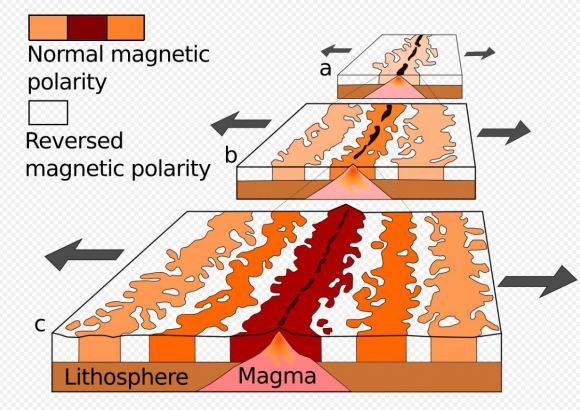
The evidence for magnetic pole reversals lies in a field known as paleomagnetism. When volcanic rocks cool, magnetic minerals within them align with Earth’s magnetic field. By analyzing the magnetic orientation of these rocks and determining their age, scientists can trace the history of Earth’s magnetic reversals. Magnetic stripes on the ocean floor, where new crust forms and records the magnetic field’s orientation, reveal patterns that point to past geomagnetic reversals. This record is invaluable for understanding Earth’s magnetic history and predicting future reversals.

The Laschamps Event: A Temporary Shift

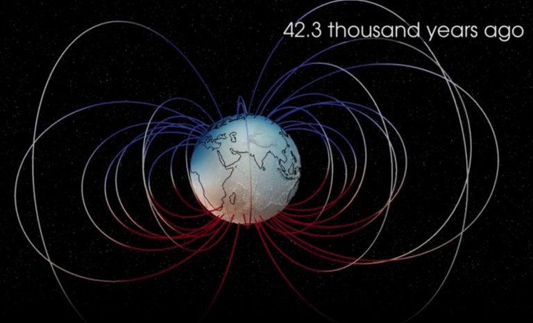
Not all magnetic field changes result in a complete pole reversal. Sometimes, the magnetic field temporarily weakens and shifts without fully reversing, an event known as a geomagnetic excursion. One of the best-known excursions is the Laschamps event, which took place around 41,000 years ago. During this period, the magnetic field was about 95% weaker than usual, significantly reducing its protective function against cosmic rays. For several hundred years, increased radiation impacted the climate, animal life, and possibly early human behavior.

The Science Behind Earth’s Magnetic Field

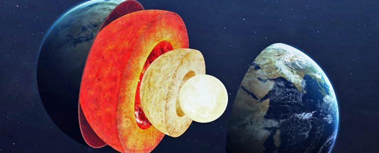
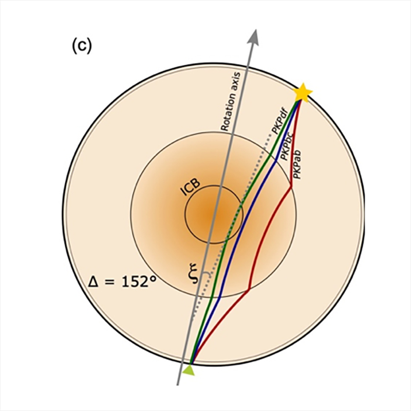
Earth’s magnetic field originates in the outer core, composed of molten iron and nickel. As this molten metal moves, it generates electric currents, which in turn create a magnetic field—a process known as the geodynamo. This geodynamo has kept Earth’s magnetic field relatively stable for millions of years, but fluctuations in the movement of molten iron can lead to reversals and excursions. Scientists continue to investigate what triggers these reversals, though they remain complex and unpredictable events.

The Sound of Earth’s Magnetic Pole Reversal A Fascinating Phenomenon
Magnetic stripes occur because the Earth’s magnetic field reverses. Seafloor spreading also plays a part. New oceanic crust forms and becomes magnetized. Then, this crust moves away from the ridge on both sides. This diagram shows a ridge at three different times. (a) It shows about 5 million years ago. (b) It shows about 2 million years ago. (c) It shows the ridge in the present day. Image Credit: By Chmee2 – derived from File:Oceanic.Stripe.Magnetic.Anomalies.Scheme.gif, Public Domain, https://commons.wikimedia.org/w/index.php?curid=18557170

Table 2: Geodynamo and Magnetic Reversal Facts

Key Aspect Description
Core Composition Mostly iron and nickel
Geodynamo Motion of molten iron creates magnetic field
Reversal Trigger Possibly related to core-mantle interactions
Time Frame for Reversal Thousands to millions of years

How Magnetic Reversals Impact Earth

The magnetic field shields Earth from cosmic radiation and solar wind, both of which are high-energy particles that can harm living organisms and technology. During a reversal, as the magnetic field weakens, Earth becomes more vulnerable to these particles. Increased exposure to cosmic rays could impact life on Earth in several ways:

  • Climate Impact: Cosmic rays can influence cloud formation, potentially altering Earth’s climate during reversals.
  • Radiation Exposure: Humans and animals, especially those at higher altitudes, might experience increased exposure to harmful radiation.
  • Biological Navigation: Many animals, such as birds and sea turtles, rely on Earth’s magnetic field for navigation. A reversal might disrupt their migratory patterns.

ESA’s Swarm Mission and the Sound of a Pole Reversal

To better understand magnetic reversals, the European Space Agency launched the Swarm mission in 2013. Swarm consists of three satellites that measure Earth’s magnetic signals from the core, mantle, oceans, ionosphere, and magnetosphere. The data collected by Swarm have been instrumental in creating a soundscape that simulates the auditory experience of a magnetic reversal.

Using data from the Laschamps event, scientists at the Technical University of Denmark crafted a soundscape that blends natural sounds like falling rocks and creaking wood with alien-like noises. The result is an eerie, pulsating composition that evokes the chaotic nature of Earth’s magnetic shifts. The soundscape was first presented as a public art installation in Copenhagen, with 32 speakers representing changes in the magnetic field at 32 global locations.

How the Sound of Reversals is Created

The Swarm team used recordings from various natural sources to replicate the intensity and unpredictability of a geomagnetic reversal. The soundscape gives listeners a visceral sense of the immense forces at play beneath Earth’s surface. Dr. Lars Nielsen, lead scientist of the project, describes the soundscape as “an attempt to bridge the gap between science and sensory experience, allowing people to feel the phenomenon rather than just learn about it.”

Implications for Future Magnetic Reversals

Though the magnetic pole reversals do not appear to pose a direct threat to life, they present potential challenges for modern technology. Communication satellites, power grids, and other infrastructure systems are sensitive to geomagnetic disturbances, which may increase during a reversal. As scientists continue to monitor the magnetic field, preparations may be necessary to protect critical systems from increased cosmic radiation and electromagnetic interference.

Facts about Magnetic Reversals

  1. Frequent Phenomenon: Earth has had about 183 magnetic reversals in the last 83 million years.
  2. Slow Process: A full reversal can take thousands to even millions of years.
  3. Weakened Shield: During a reversal, the magnetic field’s strength may drop to as low as 5% of its original level.
  4. Ancient Clues: Magnetic field orientation in rocks helps geologists trace reversals back millions of years.
  5. Navigational Impact: Some animals, like birds and whales, might be affected due to their reliance on Earth’s magnetic field.

The phenomenon of Earth’s magnetic pole reversal continues to captivate scientists and the public alike. It highlights the complexity and dynamism of Earth’s core processes, which, though invisible, have significant effects on life and technology. With missions like ESA’s Swarm, we are uncovering new ways to visualize, and even listen to, these awe-inspiring events. As research advances, we can anticipate a deeper understanding of magnetic reversals and better preparedness for future shifts.

Visit the European Space Agency’s (ESA) SoundCloud channel. They share their audio creations there.

#EarthScience, #MagneticReversal, #SwarmMission, #Geology, #CosmicRadiation, #PoleShift, #ClimateImpact, #Geodynamo, #ESA

New Geological Connection Between Earth and Venus Discovered by Scientists

Scientists have discovered a surprising geological connection between Earth and Venus, suggesting that despite the absence of plate tectonics on Venus, the planet may have experienced similar geological processes as Earth. This discovery opens new avenues for understanding planetary evolution and raises questions about Venus’s past habitability.

Summary

  • Venus is often called Earth’s “sister planet” due to their similarities in size, mass, and composition.
  • Unlike Earth, Venus lacks plate tectonics, traditionally believed to be essential for significant geological activity.
  • New research suggests that Venus’s Ishtar Terra, a highland region, may have formed through processes similar to those that created Earth’s ancient cratons.
  • Cratons are the stable, ancient cores of continents on Earth, some dating back over 2.5 billion years.
  • The discovery challenges previous assumptions about Venus’s geological history, indicating that the planet may have been more geologically active in the past.
  • This finding raises questions about the potential for past habitability on Venus and the role of similar geological processes in planetary evolution.
  • Understanding Venus’s geological history is crucial for comparative planetology and could provide insights into Earth’s own evolution.
  • Future missions to Venus should focus on gathering more data about its geology, atmosphere, and potential for past habitability.
  • The study highlights the need for continued exploration of Venus to unlock the secrets of its past and its implications for planetary science.

Venus: Earth’s Geological Twin?

Venus has long fascinated scientists due to its many similarities with Earth. Both planets are similar in size, mass, and composition, earning Venus the nickname “Earth’s sister planet.” However, the two planets have changed a lot in their geological and atmospheric development. Earth is a dynamic planet. It has active plate tectonics, which means its surface is made up of large plates that move and cause earthquakes. Venus, on the other hand, has been considered inactive for a long time. New research has found a surprising connection between the geology of Earth and Venus. This discovery challenges what we thought we knew about Venus’s history and how it relates to Earth.

Venus and Earth

Venus and Earth look very similar at first. Both are called terrestrial planets. This means they are mostly made of rock and metal. Both planets have thick atmospheres filled with carbon dioxide. They are also similar in size and density. This means they have almost the same amount of mass and take up nearly the same amount of space. However, Venus and Earth have evolved in very different ways.

Earth is a lively and ever-changing planet. Its surface changes all the time due to plate tectonics. In plate tectonics, the outer shell of the Earth, known as the lithosphere, is made up of large pieces called plates. These plates move and interact with each other. This movement forms continents, mountains, and oceans. It also creates many different geological features. Plate tectonics are very important in controlling Earth’s climate. They help create the right conditions for life to exist.

Venus, on the other hand, is very different. Thick clouds of sulfuric acid cover the planet’s surface. The atmospheric pressure is extremely high, more than 90 times that of Earth’s. Surface temperatures on Venus reach a blistering 900 degrees Fahrenheit (475 degrees Celsius). This heat is hot enough to melt lead. Because of these extreme conditions, scientists see Venus as a hostile place. They believe it has little or no tectonic activity, which means the planet’s surface does not change much through movements of the crust.

Ishtar Terra

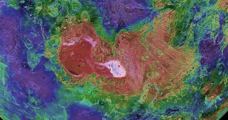
Recent research has cast doubt on the long-held belief that Venus is a geologically dead planet. A team of scientists has focused their attention on Ishtar Terra, one of the planet’s three major highland regions. Ishtar Terra, located near Venus’s north pole, is a vast plateau that includes some of the planet’s most prominent geological features, including the Maxwell Montes mountain range, which rises nearly 11 kilometers (6.8 miles) above the surrounding plains.

Ishtar Terra’s topography is strikingly similar to Earth’s highland regions, such as the Tibetan Plateau. This similarity has led scientists to wonder whether Ishtar Terra may have formed through processes analogous to those that shaped Earth’s ancient cratons. Cratons are the ancient, stable cores of continents on Earth, some of which date back over 2.5 billion years. These geological formations are among the oldest rocks on our planet and provide crucial insights into Earth’s early history.

The recent study, published in the journal Nature Geoscience, used advanced computer simulations and data from NASA’s Magellan spacecraft to explore the formation of Ishtar Terra. The researchers discovered that the highland region may have been formed by processes similar to those that created Earth’s cratons. Specifically, they found evidence that powerful upwellings of molten rock from Venus’s interior could have caused the crust to thicken and rise, creating a plateau-like structure.

This finding is surprising because it suggests that Venus, despite lacking plate tectonics, may have experienced similar geological processes as Earth. The absence of plate tectonics on Venus has long been thought to limit the planet’s ability to generate significant geological features. However, the discovery of a thick, craton-like crust in Ishtar Terra challenges this assumption and opens new possibilities for understanding Venus’s geological history.

New Geological Connection Between Earth and Venus Discovered by Scientists
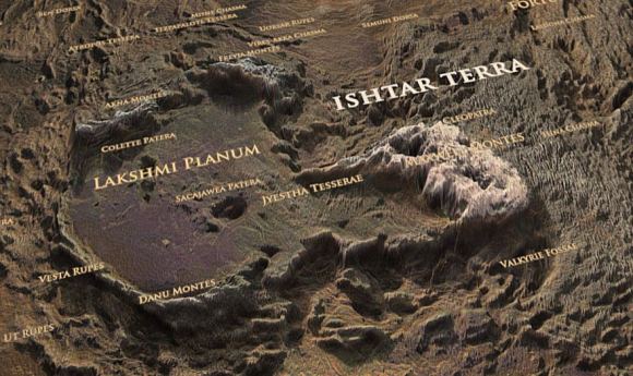
Click on the image to explore a 3D map of Ishtar Terra. This map is interactive, meaning you can click and move around it. It is available on Sketchfab, a website for sharing 3D content. The user who created this map goes by the name v7x. Image Credit: Sketchfab/v7x

Implications for Planetary Evolution

The implications of this discovery are profound. If Venus did indeed experience a period of intense geological activity, it raises important questions about the planet’s past. For example, could Venus have once had conditions similar to early Earth, including the presence of oceans and a more temperate climate? If so, what caused Venus to undergo such a dramatic transformation into the inhospitable world we see today?

Understanding what led to Venus’s current state is important. It helps us learn about how planets change over time. This knowledge is also useful when studying exoplanets, which are planets outside our solar system. Scientists want to know what makes a planet habitable, or able to support life. Venus might have important hints about how Earth developed early on. It could also show us the potential for life on other planets.

The Role of Ishtar Terra in Venus’s Geological History

To better understand the significance of Ishtar Terra, it’s essential to examine the region’s geological features in more detail. Ishtar Terra is divided into several distinct regions, each with its own unique characteristics. These include the Maxwell Montes mountain range, the Lakshmi Planum plateau, and the surrounding plains.

Maxwell Montes

Maxwell Montes is the highest mountain range on Venus, rising to an elevation of nearly 11 kilometers (6.8 miles) above the surrounding terrain. The range is composed of heavily deformed rocks, indicating a complex geological history. The presence of Maxwell Montes within Ishtar Terra suggests that the region has experienced significant tectonic forces, despite the lack of plate tectonics on Venus.

Lakshmi Planum

Lakshmi Planum is a vast, elevated plateau within Ishtar Terra, covering an area of approximately 2 million square kilometers. The plateau is characterized by smooth lava flows, indicating a history of volcanic activity. Two large shield volcanoes, Colette and Sacajawea, are also located within Lakshmi Planum. These features further suggest that Ishtar Terra has been shaped by processes similar to those that formed Earth’s cratons.

The Plains

Surrounding Ishtar Terra are vast plains, which are relatively smooth and featureless compared to the highland regions. These plains are likely the result of extensive lava flows, which have covered much of Venus’s surface over time. The transition from the highland regions to the plains provides clues about the geological processes that have shaped Venus’s surface.

Comparing Earth and Venus: Cratons and Highlands

To better understand the connection between Earth and Venus, it’s helpful to compare the geological features of the two planets. On Earth, cratons are the ancient cores of continents, and they are typically found in the center of tectonic plates. These cratons are composed of some of the oldest rocks on the planet and provide valuable insights into Earth’s early history.

Cratons are characterized by their stability and resistance to tectonic forces. They are composed of thick, rigid lithosphere, which helps them withstand the forces that reshape other parts of the Earth’s crust. This stability allows cratons to preserve a record of geological processes that occurred billions of years ago.

The discovery of a craton-like structure in Ishtar Terra suggests that Venus may have experienced similar geological processes in its past. The thick, stable crust of Ishtar Terra could be the result of upwellings of molten rock from Venus’s interior, similar to the processes that formed Earth’s cratons. This finding challenges the long-held assumption that plate tectonics are necessary for significant geological activity and suggests that other processes may be at work on Venus.

Venus’s Lithosphere

One of the key differences between Earth and Venus is the thickness of their lithospheres. Earth’s lithosphere can be as thick as 200 kilometers (124 miles) in some regions, while Venus’s lithosphere is much thinner, estimated to be between 50 and 100 kilometers (31 to 62 miles) thick. This thinner lithosphere may have significant implications for the planet’s geological history.

The thin outer layer of Venus, called the lithosphere, is likely more prone to bending and breaking than Earth’s thicker outer layer. This could be why we see large volcanic features on Venus. For example, there are shield volcanoes in an area called Lakshmi Planum. The surface of Venus is also covered with extensive lava flows. This thin lithosphere suggests that Venus has likely gone through intense periods of geological activity in the past. This happened even though it doesn’t have the same plate movement as Earth.

The Role of Volcanism in Venus’s Geological History

Volcanism has significantly shaped Venus’s surface. Large shield volcanoes are spread across the planet. Some of these volcanoes are among the largest in the solar system. Shield volcanoes have broad, gently sloping shapes. This shape is created by the eruption of lava that flows easily.

The presence of shield volcanoes in Ishtar Terra suggests that the region has been shaped by volcanic activity. This is further supported by the smooth lava flows that characterize Lakshmi Planum. The discovery of a craton-like structure in Ishtar Terra, combined with evidence of extensive volcanism, suggests that Venus’s geological history may be more complicated than previously thought.

Comparative Planetology: Lessons from Venus

The discovery of a geological connection between Earth and Venus has significant implications for the field of comparative planetology. Comparative planetology is the study of planets by comparing their characteristics and evolution. By studying the similarities and differences between planets, scientists can gain insights into the processes that shape planetary systems.

Venus and Earth provide a unique opportunity for comparative planetology. Despite their many similarities, the two planets have followed dramatically different evolutionary paths. Understanding why this divergence occurred could provide valuable insights into the factors that influence planetary evolution.

The Search for Past Habitability on Venus

One of the most intriguing questions raised by the discovery of a geological connection between Earth and Venus is the possibility of past habitability on Venus. If Venus once had conditions similar to early Earth, including the presence of liquid water, it raises the possibility that the planet could have supported life in its distant past.

Recent studies have suggested that Venus may have had a more temperate climate in its early history, with liquid water oceans that persisted for billions of years. If true, this would make Venus one of the most Earth-like planets in the solar system. However, at some point in its history, Venus underwent a dramatic transformation, leading to the extreme conditions we see today.

Understanding the factors that led to Venus’s current state is crucial for assessing the planet’s potential for past habitability. The discovery of a craton-like structure in Ishtar Terra suggests that Venus may have experienced similar geological processes as Earth, which could have played a role in the planet’s early climate and habitability.

Future Exploration of Venus

The discovery that Earth and Venus have a geological connection shows we need to explore Venus more. Venus is our closest neighbor planet, but we still know very little about it. It is one of the least explored planets in the solar system. The planet’s surface has very harsh conditions. These tough conditions make it hard to collect detailed information about its rocks, air, and history.

Future missions to Venus, such as NASA’s VERITAS mission and the European Space Agency’s EnVision mission, aim to address these challenges by providing high-resolution data about the planet’s surface and subsurface. These missions will help scientists better understand the geological processes that have shaped Venus and provide crucial insights into its past habitability.

The discovery of a new geological connection between Earth and Venus challenges our understanding of the two planets and their divergent evolutionary paths. Despite the absence of plate tectonics on Venus, the planet may have experienced similar geological processes as Earth, leading to the formation of craton-like structures in Ishtar Terra. This finding raises important questions about Venus’s past habitability and the factors that shaped its current state.

Hashtags

#Venus, #Geology, #PlanetaryScience, #Cratons, #IshtarTerra, #NASA, #SpaceExploration, #ComparativePlanetology, #Volcanism, #Habitability

Scientists Link Moon’s Swirls to Underground Magma Activity

Key Takeaway

Planetary scientists propose that the mysterious lunar swirls are linked to underground magma activity. This new theory suggests that cooling subsurface lavas, reacting in the Moon’s magnetic field, may be responsible for these enigmatic features. The study provides a fresh perspective on lunar geology and highlights the potential for future missions to unravel these mysteries further.

Summary

  • Lunar swirls are sinuous, light-colored features on the Moon’s surface.
  • These swirls extend for hundreds of kilometers and their origin is not fully understood.
  • Previous theories include meteorite impacts and surface lava flows.
  • New research suggests that underground magma cooling in a magnetic field could be causing the swirls.
  • Experiments by Michael J. Krawczynski and Yuanyuan Liang at Washington University tested this theory using the mineral ilmenite.
  • Ilmenite reacts to form magnetizable iron metal particles under lunar conditions.
  • These findings align with observations from lunar meteorites and Apollo mission samples.
  • The study emphasizes the need for future lunar missions to collect subsurface samples.
  • The upcoming Lunar Vertex mission will further investigate these swirls, particularly at Reiner Gamma.
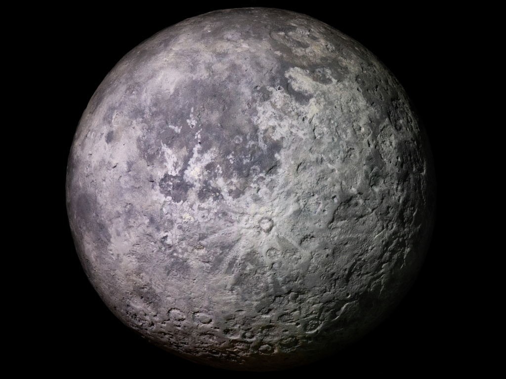
Model of the moon at an observatory

The Mystery of the Lunar Swirls

In the latest chapter of “The Mystery of the Lunar Swirls,” planetary scientists have a new theory to explain these odd markings on the Moon’s surface. It invokes underground magmas and strange magnetic anomalies.

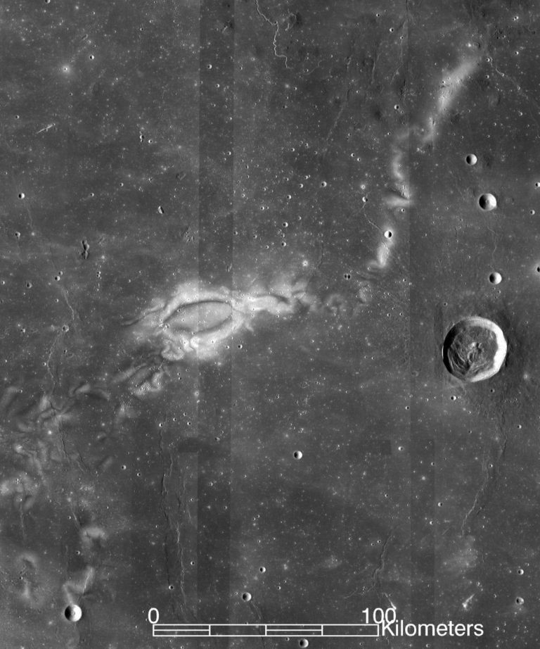
Lunar swirls are sinuous features that appear much lighter than the surrounding landscape. They extend for hundreds of kilometers and nobody’s quite sure why they exist. No astronaut has visited one of these weird regions, but that hasn’t stopped scientists from speculating based on images and magnetic field measurements. “Impacts could cause these types of magnetic anomalies,” said Michael J. Krawczynski, an associate professor of earth, environmental, and planetary sciences in Arts & Sciences at Washington University in St. Louis. Krawczynski points out that meteorites supply iron-rich material to areas on the Moon’s surface. However, these swirls exist in regions that aren’t necessarily disturbed by meteorites. So, what else could explain the swirls?

“Another theory is that you have lavas underground, cooling slowly in a magnetic field and creating the magnetic anomaly,” said Krawczynski, who, along with post-doctoral student Yuanyuan Liang, designed experiments to test this explanation. They measured the effects of different atmospheric chemistries and magmatic cooling rates on a mineral called ilmenite and found that under certain conditions, cooling subsurface lavas could be causing the ghostly lunar swirls.

Using Earth-Based Geological Principles to Understand Lunar Swirls

Despite the fact that more than a dozen people have walked on the Moon, nobody visited a lunar swirl or picked up samples of their dust. That left Earth-bound planetary scientists to use Earth analogs for Moon rocks to understand lunar magnetism. “Earth rocks are very easily magnetized because they often have tiny bits of magnetite in them, which is a magnetic mineral,” Krawczynski said. “A lot of the terrestrial studies that have focused on things with magnetite are not applicable to the Moon, where you don’t have this hyper-magnetic mineral.”

So, the research team turned to ilmenite as their test material. It’s a titanium-oxide mineral with a weak magnetic signal. Ilmenite exists all over the Moon. It readily reacts to form magnetizable iron metal particles. “The smaller grains that we were working with seemed to create stronger magnetic fields because the surface area to volume ratio is larger for the smaller grains compared to the larger grains,” Liang said. “With more exposed surface area, it is easier for the smaller grains to undergo the reduction reaction.”

Interestingly, planetary scientists have seen a similar reaction creating iron metal in lunar meteorites in samples from the Apollo missions. The difference, however, is that those samples came from surface lava flows. Krawczynski and Liang’s study focused on the types of magma that cooled underground.

The Experiment: Testing the Magma Theory

“Our analog experiments showed that at lunar conditions, we could create the magnetizable material that we needed. So, it’s plausible that these swirls are caused by subsurface magma,” said Krawczynski. “If you’re going to make magnetic anomalies by the methods we studied, then the underground magma needs to have high titanium.”

To test their theory, Krawczynski and Liang conducted a series of experiments. They recreated lunar conditions in the lab to observe how ilmenite behaves under different atmospheric chemistries and cooling rates. These experiments revealed that smaller grains of ilmenite, due to their larger surface area to volume ratio, are more reactive and more likely to form strong magnetic fields.

Table 1: Experimental Conditions and Results

Condition Observation
Low atmospheric pressure Enhanced reactivity of ilmenite grains
High titanium concentration Formation of strong magnetic fields
Slow cooling rates Increased likelihood of magnetic anomalies

Why Study Swirls on the Moon?

Those mysterious dust patterns aren’t just there by accident. They contain clues to the processes that shaped the lunar surface. In addition, if magnetism is involved in their formation, that says something about magnetism on the Moon as a whole.

Until astronauts can get to the Moon to study these swirls for themselves, the ilmenite experiment offers a good way to test the underground magma idea from afar, according to Krawczynski. Of course, it would be nice to get actual samples of underground rocks on the Moon, but that’s going to have to wait. “If we could just drill down, we could see if this reaction was happening,” he said. “That would be great, but it’s not possible yet. Right now, we’re stuck with the surface.”

Future Missions and Lunar Exploration

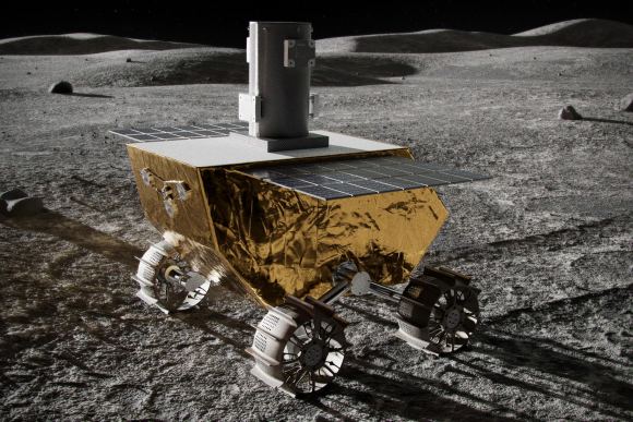
Studies like Krawczynski and Liang’s will be quite useful when NASA sends future lunar missions to the surface. There’s a whole rover project, part of a mission called Lunar Vertex, planned to study Reiner Gamma. That’s one of the Moon’s better-known swirls. Vertex should launch this year and is a predecessor to the larger return to the Moon NASA plans for later this decade. That mission could confirm whether or not swirls are magnetic field-related. If not, then there’s something else going on at Reiner Gamma and other swirl sites.

Table 2: Upcoming Lunar Missions

Mission Name Objective Launch Year
Lunar Vertex Study Reiner Gamma swirl 2024
Artemis Return humans to the Moon, including swirl study 2025
Lunar Gateway Establish lunar orbit station for further exploration 2026

Implications for Lunar Geology

The study of lunar swirls is more than an academic exercise; it has real implications for our understanding of the Moon’s geological history. The presence of magnetic anomalies suggests that the Moon once had a magnetic field, which has since faded. Understanding how these anomalies formed can provide insights into the Moon’s past magnetic activity and its cooling history.

Artist’s impression of the Lunar Vertex rover on the surface of the Moon. The rover is about 14 inches (35 centimeters) tall; the cylinder on top is the mast for the APL-built magnetometer. Credit: Johns Hopkins APL/Lunar Outpost/Ben Smith

Conclusion

The mystery of the lunar swirls is far from solved, but the work of scientists like Krawczynski and Liang brings us one step closer. Their experiments with ilmenite provide a plausible explanation for the magnetic anomalies observed in these swirls. As future missions like Lunar Vertex and Artemis prepare to explore the Moon, we can look forward to more answers and perhaps even more questions about these fascinating features.

Hashtags

#LunarSwirls, #MoonMystery, #PlanetaryScience, #LunarResearch, #MoonExploration, #NASA, #LunarVertex, #Geology, #MagneticAnomalies, #SpaceExploration

Discover the Meteor Crater in Arizona from Space on Asteroid Day

Key Takeaways

Meteor Crater in Arizona was formed 50,000 years ago by a meteorite impact. The Copernicus Sentinel-2 mission reveals the crater’s unique squared-off shape. The desert climate has preserved the crater, making it a prime site for studying impact craters. ESA’s Flyeye telescope and Hera spacecraft are part of efforts to monitor and understand asteroids.

Summary

  • Meteor Crater: A significant geological feature in Arizona formed 50,000 years ago.
  • Formation: Created by an iron-nickel meteorite impacting North America.
  • Crater Dimensions: Over 1200 meters across and 180 meters deep.
  • Unique Shape: Squared-off due to rock flaws peeling back in four directions.
  • Climate Impact: Desert climate preserved the crater by limiting erosion.
  • Geological Insights: Provides valuable information on planetary impact processes.
  • ESA’s Contributions: Flyeye telescope for asteroid monitoring and Hera spacecraft for asteroid exploration.
  • Future Missions: Aim to enhance understanding and develop asteroid deflection techniques.

Discover the Meteor Crater in Arizona from Space on Asteroid Day

The Meteor Crater in Arizona, also known as the Barringer Meteorite Crater, is one of the most well-preserved meteorite impact sites on Earth.

Approximately 50,000 years ago, an iron-nickel meteorite, estimated to be between 30-50 meters (100-165 feet) wide, crashed into what is now Arizona. This event occurred during the last ice age, a time when the region was a forested plain inhabited by mammoths and giant sloths. The immense force of the impact created a bowl-shaped crater over 1200 meters (4000 feet) across and 180 meters (600 feet) deep.

Millions of tonnes of limestone and sandstone were ejected from the crater, covering the surrounding area with debris. Large blocks of limestone, some as large as small houses, were thrown onto the crater’s rim, highlighting the violent nature of the impact.

Crater’s Unique Shape and Context

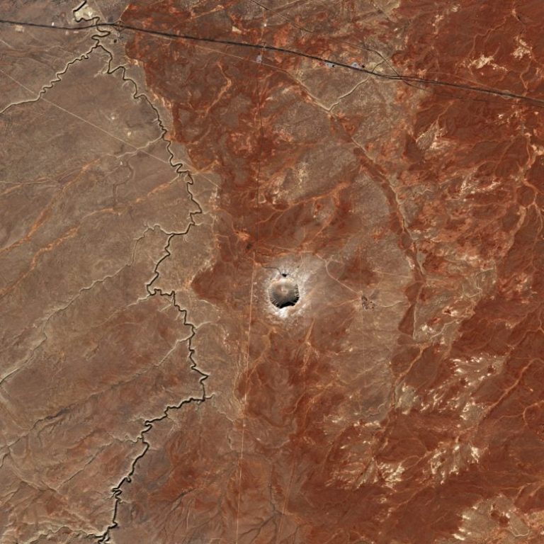
One of the most distinctive features of the Meteor Crater is its squared-off shape. This unusual shape is believed to be the result of flaws in the rock that caused it to peel back in four directions upon impact. This characteristic sets it apart from many other impact craters, which typically have a more rounded appearance.

The surrounding landscape, now a desert, was vastly different at the time of the impact. The plain was covered in forests, providing a stark contrast to the barren environment seen today. The shift in climate over millennia has dried the region, helping to preserve the crater by limiting erosion.

Meteor Crater near Winslow, Arizona, was the first impact crater to be recognized. In 1957, a young graduate student named Eugene Shoemaker convinced scientists of its origin. He became famous later for Comet Shoemaker-Levy. He showed that iron fragments, broken rocks, and melted soil were from a meteorite. They were not from a volcano. Photo courtesy of John S. Shelton.

Crater Preservation and Importance

The desert climate has played a crucial role in preserving the Meteor Crater. Unlike regions with more moisture and vegetation, the arid environment of Arizona has slowed down the erosion process, allowing the crater to remain relatively intact over thousands of years. This preservation makes the crater an excellent site for studying the process of impact cratering, which is a fundamental aspect of planetary geology.

Impact craters are found on every rocky planetary body in our solar system, from the Moon to Mars to Earth. By studying craters like the Meteor Crater, scientists can gain valuable insights into the geological processes that shape our planet and others.

Studying Impact Craters and Asteroid Monitoring

Impact craters provide a window into the violent history of our solar system. They are formed when meteorites, comets, or asteroids collide with a planetary surface, releasing immense amounts of energy and causing significant geological changes. The study of these craters can reveal information about the size, composition, and speed of the impacting bodies, as well as the nature of the target surface.

ESA’s Flyeye Telescope

As part of the global effort to monitor potentially hazardous celestial objects, the European Space Agency (ESA) is developing the Flyeye telescope. This automated telescope is designed for nightly sky surveys, aiming to identify new near-Earth objects (NEOs). The Flyeye telescope uses a unique compound eye design, splitting the image into 16 smaller sub-images to expand the field of view, much like a fly’s compound eye. This innovative approach enhances the detection of asteroids that could pose a threat to Earth.

Over the past two decades, ESA has been actively tracking and analyzing asteroids that come close to Earth. These efforts are crucial for understanding the potential risks posed by these objects and developing strategies to mitigate any threats.

Future Missions and Asteroid Deflection

ESA’s Hera spacecraft, set to launch later this year, is part of a mission to closely explore asteroids. Hera will gather detailed information about the composition, structure, and behavior of asteroids, contributing to our understanding of these celestial bodies. This knowledge is essential for developing effective strategies for asteroid deflection, should the need arise in the future.

Table 1: ESA Missions for Asteroid Monitoring and Exploration

Mission Objective Launch Date
Flyeye Telescope Automated sky surveys for NEO detection 2024
Hera Spacecraft Close exploration of asteroids Late 2024

By studying impact craters and the meteorites that create them, we can learn more about the processes and geology that shape our solar system. This knowledge is not only important for scientific understanding but also for protecting our planet from potential future impacts.

Geological Insights from Meteor Crater

The Meteor Crater offers a unique opportunity to study the effects of a meteorite impact in detail. The well-preserved state of the crater allows scientists to examine the layers of rock that were exposed and displaced by the impact. These layers provide a record of the events that occurred during and after the impact, offering valuable insights into the geological processes involved.

Table 2: Key Features of Meteor Crater

Feature Description
Diameter Over 1200 meters (4000 feet)
Depth 180 meters (600 feet)
Age Approximately 50,000 years
Unique Shape Squared-off, due to flaws in the rock
Preservation Arid desert climate limiting erosion

The study of the Meteor Crater has also contributed to our understanding of the distribution and effects of impact debris. The ejected material, which covers the ground for over a kilometer in every direction, includes large blocks of limestone and sandstone, as well as finer debris. Analyzing this material helps scientists understand the forces involved in the impact and the resulting geological changes.

Conclusion

The Meteor Crater in Arizona is a remarkable geological feature that provides valuable insights into the processes that shape planetary surfaces. Its unique squared-off shape, well-preserved state, and extensive debris field offer a wealth of information for scientists studying impact craters and planetary geology.

ESA’s efforts, including the development of the Flyeye telescope and the upcoming Hera spacecraft mission, underline the importance of monitoring and understanding asteroids. These initiatives are crucial for advancing our knowledge of these celestial bodies and developing strategies to protect our planet from potential impacts.

Hashtags:

#MeteorCrater, #AsteroidDay, #ESA, #ImpactCraters, #FlyeyeTelescope, #HeraSpacecraft, #Geology, #PlanetaryScience, #AsteroidMonitoring, #SpaceExploration

Earth’s Shield Collapsed 41,000 Years Ago

Summary

A study on the Laschamps excursion, an event 41,000 years ago when Earth’s magnetic shield weakened, reveals that the transition from normal to reversed field took 250 years and stayed reversed for about 440 years. During this period, the shield weakened to 25% of its normal strength, allowing more cosmogenic radionuclides to reach Earth’s surface. The weakening of the shield also affected the ozone layer, climate, and wind patterns. Although the event has been linked to extinctions and cave art, the effects of cosmic rays when the shield is weak remain uncertain.

Key Takeaways

  • The Laschamps excursion occurred 41,000 years ago when Earth’s magnetic shield weakened, allowing cosmic rays to reach the atmosphere.
  • Radionuclides from cosmic rays were embedded in sediments, ice cores, and living things.
  • The Earth’s magnetic field transitioned from normal to reversed over 250 years and remained reversed for around 440 years.
  • The weakening of the shield affected the ozone layer, climate, and wind patterns.
  • The Laschamps event has been linked to extinctions and cave art, but these links lack strong scientific evidence.
  • The effect of cosmic rays on life when the shield is weak is uncertain.
  • The magnetic shield is not static, and anomalies like the South Atlantic Anomaly exist.
Earth's Shield Collapsed 41,000 Years Ago
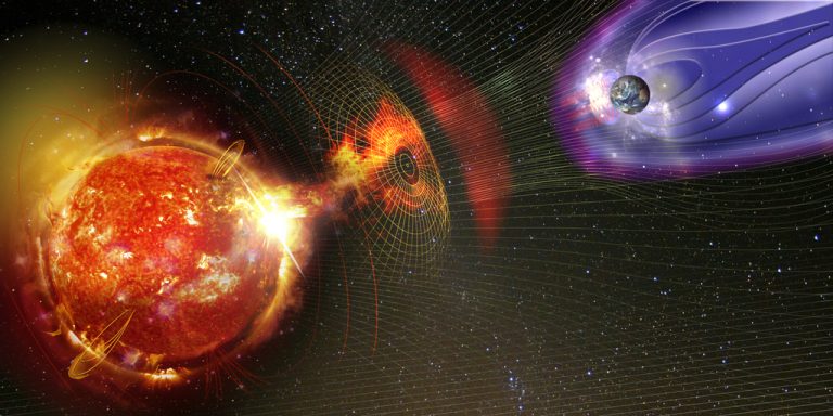
Magnetic lines of force surrounding Earth known as the magnetosphere deflecting solar wind and radiation from the Sun. Elements of this image furnished by NASA.

Earth’s Shield Collapsed 41,000 Years Ago

Earth is vulnerable without its protective barrier. This barrier is the planet’s magnetic shield, which keeps cosmic rays at bay. However, occasionally, this shield weakens and fluctuates. When this happens, cosmic rays penetrate and hit the atmosphere, generating a shower of particles. Scientists believe these particles could significantly damage the biosphere.

One example occurred 41,000 years ago during an event known as the Laschamps excursion.

Cosmic rays are high-energy particles, typically protons or atomic nuclei, that travel at extremely high speeds. Under normal conditions, the Earth’s magnetic shield deflects these away from the planet. But the shield can change in strength and orientation, allowing cosmic rays to strike the Earth’s atmosphere.

Earth's Shield Collapsed 41,000 Years Ago
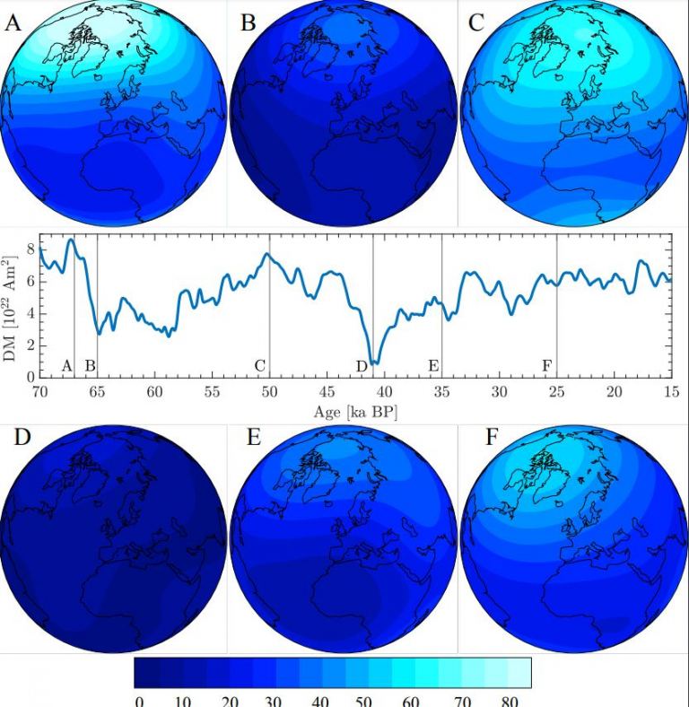
Each map displays the intensity of Earth’s geomagnetic field at different moments in time. These maps are based on reconstructions by Panovska. They use paleomagnetic data and records of cosmogenic beryllium-10 radionuclides. DM stands for Dipole Moment. This measures the field’s polarity, indicating the separation of positive and negative charges. Age [ka BP] represents the map’s age in thousands of years before the present. Image credit goes to Sanja Panovska.
This interaction produces a spray of secondary particles called cosmogenic radionuclides. These isotopes are found in sediments, ice cores, and even within the structures of trees. They include various types, such as Calcium 41 and Carbon 14.

These isotopes vary in stability. Some are stable, while others are radioactive, with half-lives ranging from 20 minutes for Carbon 11 to 15.7 million years for Xenon 129.

When the Earth’s magnetic shield weakens, more isotopes reach and accumulate on the surface. By studying sediment and ice cores, scientists can track the history of the magnetic shield. Research shows that there was a geomagnetic excursion or reversal, called the Laschamps excursion, identified through geomagnetic anomalies in the Laschamps lava flows in France.

Earth's Shield Collapsed 41,000 Years Ago
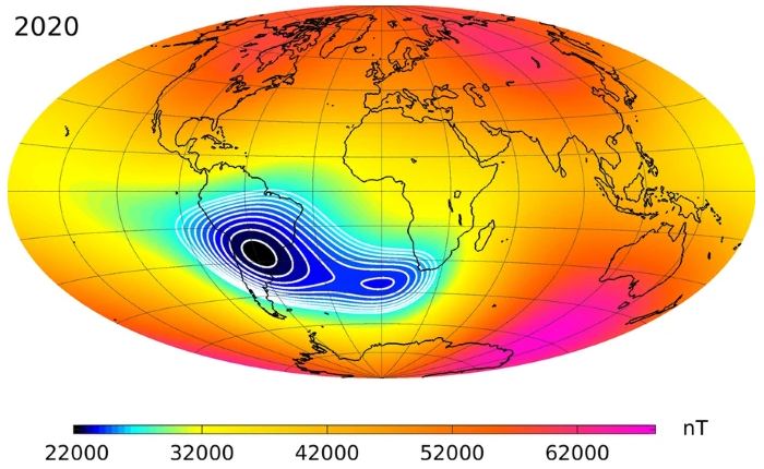
The ‘South Atlantic Anomaly’ is an area where Earth’s magnetic shield is weaker. This information comes from a study by Christopher C. Finlay and colleagues. The study is titled “The CHAOS-7 geomagnetic field model and observed changes in the South Atlantic Anomaly”. It was published in Earth, Planets, and Space in 2020. You can find it under article number 156. The image showing the anomaly is credited under CC BY-SA 4.0.

The Earth’s magnetic poles typically flip every few hundred thousand years, switching North to South and vice versa. Between these flips are lesser events known as excursions, where the poles drift without fully switching. These excursions can last from a few thousand up to tens of thousands of years, weakening the Earth’s shield and allowing more cosmic rays to hit the atmosphere, thereby increasing radionuclide production.

Scientists, in paleomagnetic studies, often focus on Beryllium 10. This isotope, with a half-life of 1.36 million years, accumulates on the soil surface.

Sanja Panovska, a geomagnetism researcher at GFZ Potsdam, Germany, presented findings on the Laschamps excursion at the European Geosciences Union General Assembly in 2024. She reported that during this period, production of Beryllium 10 doubled. She combined data on cosmogenic radionuclides and paleomagnetic studies to reconstruct the magnetic field at that time. Her findings indicated that the magnetic field weakened to 5% of its normal strength during the transition to a reversed field, which lasted about 250 years. The field stayed reversed for about 440 years and operated at about 25% of its regular strength during that period. This significant weakening allowed more cosmogenic radionuclides to reach Earth’s surface.

These isotopes not only accumulate in sediments and ice, but also impact the ozone layer and climate. Lowering the shield and the ozone layer allows more UV radiation to reach us, cooling the high-altitude atmosphere and altering wind flows, possibly causing severe changes on Earth’s surface.

This event, the Laschamps excursion, has been suggested as a factor contributing to significant events like the extinction of Neanderthals and the emergence of cave art. Although these correlations lack robust scientific support, such events pose real risks; a similar modern occurrence could disrupt power grids and cause widespread auroras in equatorial regions.

Panovska stressed the importance of understanding these extreme events for predicting future space climate and assessing environmental impacts.

The magnetic shield displays anomalies, like the South Atlantic Anomaly, where the field is weakest. This affects satellites, exposing them to higher radiation levels, showing the complex nature of Earth’s magnetic field.

Understanding the impact of cosmic rays during periods when the magnetic shield is weak is crucial. Although it’s tempting to link events like the Laschamps excursion with major extinctions directly, the relationship is not straightforward since life continues despite numerous shifts and reversals in the magnetic poles.

Hashtags:

#EarthScience, #Geology, #MagneticShield, #ClimateChange, #CosmicRays #Earth’s Shield Collapsed

Juno Discovers Massive Lava Lake on Io

Key Takeaway

Juno spacecraft’s close flybys of Jupiter’s moon Io revealed a giant lava lake called Loki Patera, providing detailed insights into the moon’s volcanic activity and surface features. Scientists also concluded that Io has been erupting volcanically since the early Solar System due to tidal heating.

Summary

  • Juno spacecraft made close flybys of Jupiter’s moon Io, revealing new details about its surface.
  • A giant lava lake named Loki Patera was observed, showcasing volcanic activity.
  • Juno captured images of Io’s northern latitudes, revealing its pizza-like appearance, caused by volcanic activity.
  • Io exhibits various surface features like volcanic plumes, lava flows, and calderas.
  • Scientists recreated features like “The Steeple,” a spired mountain on Io, using JunoCam data.
  • Recent papers concluded that Io has been erupting volcanically since the early Solar System due to tidal heating.
  • Observations with ALMA in Chile revealed isotopic evidence of long-lived volcanism on Io, indicating billions of years of tidal heating.
  • Juno will continue to explore Jupiter’s system, with its latest flyby of Io on April 9 and upcoming flyby on May 12.
  • JunoCam allows public participation in selecting imaging targets and processing data.

Exploring the Fiery Depths of Io

Jupiter’s moon Io has long fascinated astronomers and space followers alike with its otherworldly landscapes and intense volcanic activity. Recent revelations from NASA’s Juno spacecraft have further deepened our understanding of this mysterious moon, Revealing breathtaking details of its fiery surface and shedding light on its geological history.

One of the most striking discoveries made by Juno is the observation of a massive lava lake known as Loki Patera. Stretching over 200 kilometers, this colossal lava lake is surrounded by islands within a depression filled with molten magma. Juno’s close flybys provided unprecedented views of this geological wonder, revealing a landscape reminiscent of Earth’s volcanic regions but on a grander scale.

Io’s surface shows its violent volcanic past. It is covered with vents, calderas, and lava flows. Juno’s sharp images reveal Io’s changing geology. They show bright plumes and complex designs formed by thousands of years of volcanic activity. Io has high mountains and wide lava plains. These features show the strong forces active below its surface.

Io has a unique mountain called “The Steeple.” It is very tall, standing between 5 and 7 kilometers high. This mountain shows how intense volcanic activity has formed Io’s surface for billions of years. Thanks to Juno’s observations, scientists can understand Io’s geological history. They learn how its volcanoes work.

Io’s volcanic activity comes from its special orbit around Jupiter. Its eruptions are caused by tidal heating. This heating happens because of gravity from Jupiter and its moons, Europa and Ganymede. Studies with data from ALMA show Io’s volcanoes have been active for billions of years. This activity has changed Io’s surface and atmosphere.

Juno’s mission continues to solve the mysteries of Io and the wider Jupiter system. With each close flyby, Juno gathers invaluable data that enhances our understanding of Io’s geology and its significance in planetary science. Furthermore, JunoCam invites the public to participate in this journey of exploration, allowing followers to engage with the mission and contribute to the study of Io’s volcanic landscapes.

Hashtags:

#Juno #Io #Volcanoes #SpaceExploration #PlanetaryScience #Astronomy #NASA #Jupiter #LavaLake #Geology #Astrophysics #Massive Lava Lake On Io
Pin It
error: Content is protected !!

On this website we use first or third-party tools that store small files (<i>cookie</i>) on your device. Cookies are normally used to allow the site to run properly (<i>technical cookies</i>), to generate navigation usage reports (<i>statistics cookies</i>) and to suitable advertise our services/products (<i>profiling cookies</i>). We can directly use technical cookies, but <u>you have the right to choose whether or not to enable statistical and profiling cookies</u>. <b>Enabling these cookies, you help us to offer you a better experience</b>.