Tag

#GeologicalHistory

Browsing

Rings Around Earth: Could Earth Have Had Rings 500 Million Years Ago? Scientists Explore

Scientists have proposed that Earth may have had a ring system 466 million years ago due to a near-collision with a large asteroid. This theory suggests the asteroid broke apart within Earth’s gravitational field, forming a debris ring. Over time, the ring particles descended into the Earth’s atmosphere, causing a series of impacts that left craters visible today. While evidence is still being studied, researchers are exploring the possibility that Earth once had a ring system similar to Saturn’s.

Summary

  • Saturn’s iconic rings have fascinated people for centuries.
  • Other gas giants, Jupiter, Uranus, and Neptune, also have rings.
  • Earth may have had a ring system 466 million years ago, according to recent studies.
  • Scientists discovered increased meteorite activity recorded in limestone deposits.
  • These meteorites are chondritic and were likely part of an asteroid that broke up near Earth.
  • The debris from this event would have created a temporary ring.
  • 21 known meteorite impact sites correspond to the period of increased asteroid activity.
  • The Ordovician period saw an uptick in seismic and tsunami events, possibly linked to this debris.
  • The debris would have gradually fallen to Earth, forming the craters seen today.
  • This theory is supported by increased levels of asteroid dust in Earth’s geological record.
  • A similar phenomenon of tidal disruption is what likely formed the rings of Saturn.
  • The Roche limit describes how Earth’s gravity could break up a near-miss asteroid.
  • This event may have created a meteor shower lasting millions of years.
  • Modern technology helps scientists analyze limestone deposits for clues about ancient meteorite impacts.
  • This fascinating possibility opens up new avenues for studying Earth’s ancient history.
Rings Around Earth: Could Earth Have Had Rings 500 Million Years Ago? Scientists Explore
This photo from NASA’s Hubble Space Telescope shows cloud bands on Saturn. It also reveals a phenomenon called ring spokes. Ring spokes are temporary, dark patches that appear in Saturn’s rings. This photo was taken by NASA, the European Space Agency (ESA), and the Space Telescope Science Institute (STScI). Amy Simon from NASA’s Goddard Space Flight Center (GSFC) also contributed.

Could Earth Have Had Rings 500 Million Years Ago?

We are all familiar with the iconic rings of Saturn, which are a striking feature in our solar system. But have you ever wondered if Earth might have had rings at some point in its history? Scientists are now suggesting that Earth may have indeed had a ring system around 466 million years ago. Evidence from a series of impact craters, meteoritic dust found in limestone deposits, and a rise in seismic activity during the Ordovician period all point to the possibility that a ring of debris once orbited Earth.

Saturn and the Gas Giants: A Lesson in Rings

The rings of Saturn, Jupiter, Uranus, and Neptune are composed of chunks of ice and rock that orbit these planets in a circular pattern. These rings, although appearing smooth from afar, are made up of countless particles that range in size from dust grains to mountains. The formation of these rings is still a topic of scientific debate, but one popular theory suggests that the rings were formed from celestial bodies like moons or asteroids that wandered too close to the planets. The intense gravitational pull of these massive gas giants tore the objects apart, leaving behind a trail of debris known as tidal disruption.

Seeing the rings of Saturn against an inky black sky are the very things that grabbed my attention as a ten-year-old boy,” said an astronomer, recalling his fascination with space.

Earth’s Rings? The Evidence Begins

A team of researchers, led by Andrew G. Tomkins, recently published a paper proposing that Earth could have had rings during the Ordovician period. Their hypothesis is based on evidence collected from limestone deposits around the world, which show an increase in meteoritic dust during this time. The meteoritic material, primarily made up of chondrite meteorites, suggests that Earth experienced a dramatic uptick in asteroid activity around 466 million years ago.

The researchers hypothesized that a large asteroid likely passed within Earth’s Roche limit—the point at which an object’s gravity is no longer strong enough to hold it together against the planet’s tidal forces. This close encounter would have caused the asteroid to break apart, creating a debris ring around Earth. Over time, this debris would have gradually fallen into Earth’s atmosphere, creating meteor showers and leaving impact craters across the globe.

Table 1: Characteristics of Gas Giant Rings

Planet Composition of Rings Estimated Age of Rings Tidal Disruption Event
Saturn Ice and rock 100 million years Likely
Jupiter Dust and small particles Few million years Possible
Uranus Dark particles Unknown Likely
Neptune Ice and dust Unknown Possible

Meteorite Impact Events

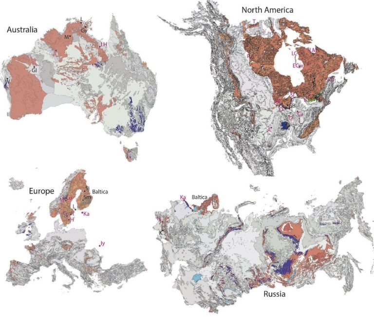
Researchers have identified 21 meteorite impact sites that correspond with the period of increased asteroid activity in the Ordovician period. These impacts, located mainly near Earth’s equator, are believed to be the result of debris from the destroyed asteroid that formed the ring system. The debris would have been drawn toward Earth over a span of millions of years, creating impact craters that are still visible today.

One of the most famous impact craters from this period is the Barringer Crater in Arizona, also known as Meteor Crater. This large crater, created around 50,000 years ago, was formed by the impact of a nickel-iron meteorite. Though it’s much younger than the debris ring event, it serves as an example of the damage such impacts can cause.

Table 2: Notable Meteorite Impact Sites

Impact Crater Location Estimated Age Meteorite Type
Barringer Crater Arizona, USA 50,000 years Nickel-Iron Meteorite
Chicxulub Crater Yucatán, Mexico 66 million years Asteroid
Clearwater Lakes Quebec, Canada 290 million years Asteroid
Manicouagan Crater Quebec, Canada 214 million years Asteroid

The Ordovician Period: A Time of Change

The Ordovician period, which lasted from about 485 million to 444 million years ago, was a time of significant geological and biological change on Earth. During this time, the planet experienced increased seismic and tsunami activity, which some researchers believe could be linked to the asteroid debris that formed the ring system. However, this correlation remains unconfirmed.

Interestingly, the Ordovician meteorite shower coincided with a rise in marine life and the expansion of new species. This suggests that the increased asteroid activity, while destructive in some areas, may have also played a role in shaping the planet’s ecosystems.

Ring Decay: A Gradual Process

If Earth did have a ring system 466 million years ago, it wouldn’t have lasted forever. Over time, the individual chunks of debris would have slowly descended into Earth’s atmosphere, creating a steady rain of meteoritic material. This decay process likely lasted for tens of millions of years, with the ring particles gradually becoming incorporated into the planet’s geological record. Scientists believe that this material can still be found today in the form of chondritic meteorites embedded in limestone deposits.

The possibility that Earth once had a ring system is a fascinating hypothesis that challenges our understanding of the planet’s history. The evidence presented by Andrew G. Tomkins and his team provides a compelling case for the existence of a debris ring around Earth 466 million years ago. By studying impact craters, meteorite deposits, and limestone records, scientists have uncovered new clues about the planet’s ancient past.

While much more research is needed to confirm this theory, the idea that Earth once had rings opens up exciting possibilities for future discoveries. As we continue to explore our planet’s history, we may find that Earth’s Ordovician rings were just one of many mysteries waiting to be uncovered.

References

#EarthRings, #AsteroidImpact, #OrdovicianPeriod, #SpaceScience, #GeologicalHistory, #Meteorites, #Chondrite, #LimestoneDeposits, #SeismicActivity, #CraterFormation, #SolarSystem, #RocheLimit, #PlanetaryRings, #AsteroidDebris, #NASAResearch

Lunar Lava Tube Entrance Mapped by Space Technology

Key Takeaways

Lava tubes on the Moon are hollow tunnels created by ancient volcanic activity. A team of researchers has created the first 3D map of a lunar lava tube entrance using radar reflections. NASA’s Lunar Reconnaissance Orbiter (LRO) played a crucial role in this discovery. Lava tubes could serve as ideal locations for future lunar research stations. The discovery was published in Nature Astronomy by the University of Trento in Italy. Lunar lava tubes can provide natural protection from harsh lunar conditions.

Summary

  • Lava tubes are a result of ancient volcanic activity.
  • NASA’s LRO has been mapping the Moon since 2009.
  • A team led by the University of Trento confirmed the existence of a lunar lava tube.
  • The LRO’s Miniature Radio-Frequency instrument was key in this discovery.
  • The discovery underscores the importance of reanalyzing historical data with modern techniques.
  • Lava tubes can protect future lunar explorers from extreme temperatures and radiation.
  • Establishing research stations in lava tubes could be safer and more cost-effective.
  • Further remote sensing and exploration are essential for identifying more lava tubes.
Lunar Lava Tube Entrance Mapped by Space Technology
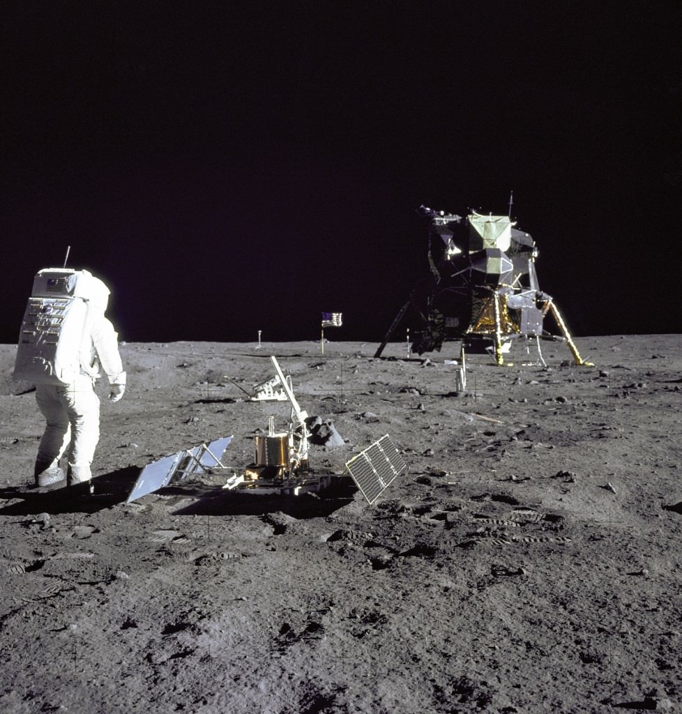
Buzz Aldrin looks at Tranquility Base during the Apollo 11 moonwalk. Neil Armstrong took the picture. Credit: NASA

Lunar Lava Tube Entrance Mapped by Space Technology

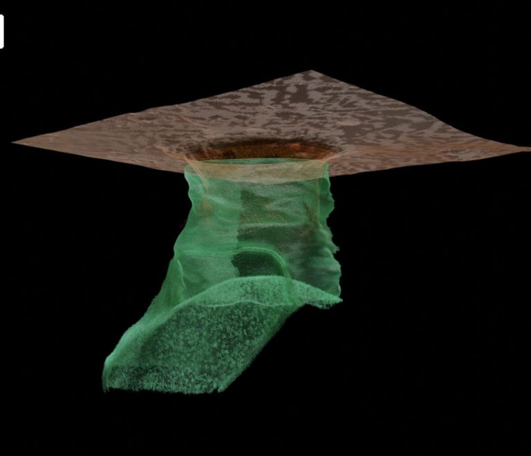
Craters are a familiar sight on the lunar surface and indeed on many of the rocky planets in the Solar System. However, not all circular features on the Moon are craters. Some of these pits are believed to be the collapsed roofs of lava tubes. Researchers have recently mapped one of these tubes using radar reflections, creating the first 3D map of the tube’s entrance. These tubes could be ideal locations for setting up research stations, providing protection from the harsh lunar environment.

What Are Lava Tubes?

Lava tubes have been a subject of debate for the last 50 years. They form due to ancient volcanic activity. When the surface of a lava flow cools and hardens, the molten lava beneath continues to move. Eventually, the molten lava drains away, leaving behind a hollow tunnel. These tunnels can offer a preserved record of the Moon’s geological history.

The Role of NASA’s Lunar Reconnaissance Orbiter (LRO)

NASA’s Lunar Reconnaissance Orbiter (LRO) has been instrumental in the study of lunar lava tubes. Launched in 2009, the LRO’s mission is to gather detailed information about the Moon’s surface and environment. Equipped with scientific instruments, the LRO captures high-resolution imagery, maps temperature variations, measures radiation levels, and identifies water ice deposits.

Breakthrough Discovery by International Team

A team of scientists from around the world, led by the University of Trento in Italy, made a groundbreaking discovery. Published in Nature Astronomy, the team confirmed the existence of a tunnel just beneath the lunar surface. This tunnel is an empty lava tube, a theory that had remained unproven until now.

Key Data from LRO’s Miniature Radio-Frequency Instrument

The discovery was made possible by the LRO’s Miniature Radio-Frequency instrument. In 2010, the instrument surveyed Mare Tranquilitatis, the site of Apollo 11’s historic landing in 1969. The data included information about a nearby pit. Using modern signal processing techniques, researchers reanalyzed the data, revealing previously unidentified radar reflections that suggest an underground cave or tunnel.

This represents an underground tunnel on the surface of the Moon, but it is an accessible tunnel too,” said the research team from the University of Trento.

Importance of Historical Data Analysis

The discovery highlights the significance of analyzing historical data with modern techniques. Decades-old data can reveal new information when reexamined with advanced technology. This finding underscores the need for continued remote sensing and lunar exploration to identify more lava tubes.

Protective Benefits of Lava Tubes

The lunar environment is incredibly harsh. Temperatures can range from 127 degrees Celsius on the illuminated side to -173 degrees Celsius on the night side. Solar radiation on the Moon can be up to 150 times more powerful than on Earth, and there’s no atmosphere to protect against meteorite impacts. Structures built on the lunar surface must withstand these extreme conditions.

However, lava tubes offer natural protection. They can shield against temperature extremes, solar radiation, and meteorite impacts, making them ideal for establishing a lunar presence. Setting up research stations within these tubes could be a safer and more cost-effective solution compared to surface structures.

Future Exploration and Research

The discovery of the lunar lava tube is a significant step forward, but more work is needed. Continued exploration and remote sensing are essential to map additional lava tubes. Identifying these tubes is crucial for planning future lunar missions and establishing a sustainable human presence on the Moon.

Conclusion

The mapping of a lunar lava tube entrance using space technology marks a significant achievement in lunar exploration. Lava tubes, formed by ancient volcanic activity, offer valuable insights into the Moon’s geological history and provide a potential refuge for future lunar explorers. NASA’s Lunar Reconnaissance Orbiter has played a vital role in this discovery, demonstrating the importance of reanalyzing historical data with modern techniques. As we continue to explore the Moon, lava tubes may prove to be key in creating safe and sustainable research stations.

Tables

Table 1: Key Features of Lunar Lava Tubes

Feature Description
Formation Created by ancient volcanic activity when molten lava flows and drains away, leaving behind hollow tunnels.
Protection Provides natural shielding from extreme temperatures, solar radiation, and meteorite impacts.
Geological Insights Preserves records of the Moon’s geological history, offering valuable information for researchers.
Accessibility Some lava tubes have collapsed roofs, creating pits that can be mapped and accessed.
Potential Use Ideal locations for establishing research stations and future lunar habitats due to their protective environment.

Table 2: Instruments on the Lunar Reconnaissance Orbiter (LRO)

Instrument Name Function
Miniature Radio-Frequency Used for mapping lunar surface features and identifying subsurface structures such as lava tubes through radar reflections.
Lunar Orbiter Laser Altimeter Measures the topography of the Moon’s surface with high precision.
Lyman-Alpha Mapping Project Maps the distribution of hydrogen and other elements on the lunar surface.
Diviner Lunar Radiometer Measures surface temperatures and thermal properties of the Moon.
LROC (Lunar Reconnaissance Orbiter Camera) Captures high-resolution images of the lunar surface to map its features and monitor changes over time.

References

  1. Existence of lunar lava tube cave demonstrated: University of Trento
  2. NASA Lunar Reconnaissance Orbiter: NASA
  3. Nature Astronomy publication: Nature Astronomy

Hashtags

#LunarExploration, #LavaTubes, #SpaceTechnology, #NASA, #LRO, #MoonResearch, #VolcanicActivity, #LunarResearchStations, #GeologicalHistory, #SpaceScience

The Science Behind Meteorites Striking the Surface of Mars Daily

Key Takeaway

Meteorites strike the surface of Mars daily, with NASA’s InSight lander and its SEIS instrument providing critical data to understand these impacts. This data has allowed scientists to estimate impact rates, revealing insights into the geological history and potential hazards for future missions.

Summary

  • NASA’s InSight Mars Lander’s SEIS instrument collected seismic data on Mars for over four years.
  • Researchers used this data to determine a new meteorite impact rate for Mars.
  • SEIS detected over 1300 seismic events, with a portion attributed to meteorite impacts.
  • Scientists estimate that 280 to 360 meteoroids, about the size of basketballs, strike Mars each year.
  • This rate is five times higher than previously estimated from orbital imagery.
  • Impact rates help understand the age of Mars’ surface and provide insight into its geological history.
  • The study shows that seismometers are reliable tools for measuring impact rates on Mars.
  • The data has broader implications for understanding impact rates throughout the Solar System.
  • Frequent impacts create significant blast zones, posing potential hazards for future Mars missions.
  • Understanding meteorite impacts on Mars is crucial for the safety and planning of robotic and human missions.

Introduction

Mars, our neighboring red planet, experiences daily meteorite impacts that shape its surface and reveal much about its geological history. NASA’s InSight Mars Lander, equipped with the Seismic Experiment for Interior Structure (SEIS), has provided invaluable data to understand these impacts.

SEIS and Its Mission

NASA’s InSight lander, which arrived on Mars on November 26, 2018, was equipped with several scientific instruments, including SEIS. The primary goal of SEIS was to probe Mars’ interior by measuring seismic waves from marsquakes and meteorite impacts. Over four years, SEIS recorded more than 1300 seismic events, allowing scientists to analyze the frequency and impact of meteoroids on Mars.

The Role of SEIS

  • SEIS: Designed to detect seismic waves caused by marsquakes and meteorite impacts.
  • Placement: Positioned on Mars’ surface on December 19, 2018, and later covered with a protective shell to shield it from wind.
  • Data Collection: Collected seismic data for over four years, recording over 1300 seismic events.

Determining Impact Rates

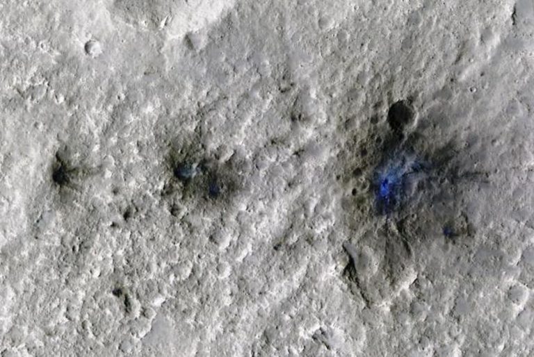
Researchers faced the challenge of distinguishing between seismic events caused by marsquakes and those caused by meteorite impacts. Despite this difficulty, six events near the InSight lander were confirmed as meteorite impacts due to their correlation with acoustic signals produced when meteors entered Mars’ atmosphere. These events helped establish a new estimate for Mars’ impact rates.

Analyzing Seismic Data

  • Confirmed Impacts: Six events were confirmed as meteorite impacts through acoustic signal correlation.
  • VF Events: InSight detected 70 very high-frequency (VF) events, with 59 having good distance estimates.
  • Impact Quakes: Impact-generated quakes are characterized by shorter durations compared to typical marsquakes.
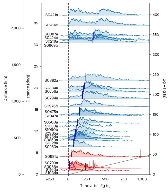
This figure from the research shows envelopes of recorded VF quality B events sorted by distance. The graph plots data from 120 seconds before to 1,100 seconds after the event. The events are aligned by their first signal (Pg) arrival. The blue lines represent the second signal arrival (Sg.) The six red events are confirmed impact events. For those impact events, the black lines show where the “chirp” signal arrives. The chirp signal is a unique marker that indicates an impact event has occurred. Image Credit: Zenhäusern, Wójcicka et al. 2024.

New Impact Rate Estimate

The data from SEIS led to a significant finding: Mars experiences between 280 and 360 meteoroid impacts annually, creating craters greater than 8 meters in diameter. This rate is five times higher than previous estimates based on orbital imagery alone, highlighting the effectiveness of seismology in measuring impact rates.

Impact Frequency and Crater Formation

  • Impact Rate: Between 280 and 360 meteoroids strike Mars each year, forming craters larger than 8 meters.
  • Comparison: This rate is five times higher than estimates from orbital images.
  • Crater Size: Larger craters are formed almost daily, with significant blast zones around them.

Implications for Geological History

Impact rates are crucial for understanding the geological history of planetary surfaces. Earth’s surface is constantly reshaped by geological activity, but bodies like the Moon and Mars rely on impact rates to determine surface ages. Mars’ impact rate provides insights into its geological history and helps compare it with other celestial bodies.

Understanding Surface Ages

  • Surface Ages: Impact rates help determine the age of planetary surfaces.
  • Comparison: Mars’ impact rate can be compared with data from the Moon and other bodies.
  • Geological History: Provides a deeper understanding of Mars’ geological history.
NASA's InSight lander put its seismometer on Mars on December 19, 2018. They called this seismometer SEIS. Later, they covered SEIS with a protective shell. This shell protects it from wind. Image Credit: NASA/JPL-Caltech
NASA’s InSight lander put its seismometer on Mars on December 19, 2018. They called this seismometer SEIS. Later, they covered SEIS with a protective shell. This shell protects it from wind. Image Credit: NASA/JPL-Caltech

Challenges in Measuring Impact Rates

Accurately measuring impact rates on Mars presents challenges due to its unique environment. Mars’ gravity, proximity to the asteroid belt, and frequent dust storms complicate observations. Seismology, as demonstrated by SEIS, offers a more reliable method to overcome these challenges.

Factors Affecting Impact Rate Measurement

  • Gravity: Mars’ gravity influences the number of meteoroids striking its surface.
  • Asteroid Belt: Proximity to the asteroid belt increases the frequency of meteoroids.
  • Dust Storms: Dust storms can obscure craters, making orbital observations difficult.
  • Surface Types: Varied surface regions affect the visibility of craters.

Broader Implications for the Solar System

Understanding Mars’ impact rate extends beyond the red planet. It provides valuable data for the entire Solar System, helping to determine the absolute ages of surfaces and offering insights into the history of other celestial bodies.

Solar System Impact Rates

  • Solar System: Mars’ impact rate helps determine surface ages throughout the Solar System.
  • Historical Insights: Offers a clearer understanding of the Solar System’s history.

Safety Considerations for Future Missions

The high frequency of meteorite impacts on Mars poses potential hazards for future robotic and human missions. Understanding these impacts is crucial for mission planning and ensuring the safety of equipment and personnel.

Mission Planning and Safety

  • Hazards: Frequent impacts and large blast zones pose risks.
  • Planning: Accurate impact rate data is essential for safe mission planning.
  • Future Missions: Ensures the safety of robotic and human explorers.
This figure from the research shows crater size and seismic moment for the six confirmed impacts near the InSight lander. Circles show single craters. Triangles show the effective diameter of crater clusters. The vertical error bars show the uncertainty in seismic moment magnitude. This magnitude is calculated using standard error propagation techniques. The horizontal error bars come from the resolution of HiRISE images. These images are used to determine the crater sizes. Image Credit: Zenhäusern, Wójcicka et al. 2024.

Conclusion

NASA’s InSight Mars Lander and its SEIS instrument have revolutionized our understanding of meteorite impacts on Mars. The data collected over four years has provided a new estimate for impact rates, revealing that Mars experiences almost daily impacts. This information is vital for understanding Mars’ geological history, planning future missions, and ensuring the safety of explorers.

Tables

Table 1: SEIS Data Summary

Parameter Value
Total Seismic Events 1300+
Confirmed Meteorite Impacts 6
VF Events 70
Annual Impact Rate 280-360 meteoroids
Crater Size (Daily) >8 meters
Crater Size (Monthly) ~30 meters

Table 2: Impact Rate Comparison

Method Estimated Impact Rate (Annual)
Orbital Imagery ~60-70
Seismology (SEIS) 280-360
Increase Factor 5x

Hashtags

#Mars, #NASA, #InSight, #SEIS, #MeteoriteImpacts, #MarsExploration, #Seismology, #SpaceScience, #AsteroidBelt, #FutureMissions, #GeologicalHistory, #SolarSystem, #SpaceSafety, #PlanetaryScience

Pin It
error: Content is protected !!

On this website we use first or third-party tools that store small files (<i>cookie</i>) on your device. Cookies are normally used to allow the site to run properly (<i>technical cookies</i>), to generate navigation usage reports (<i>statistics cookies</i>) and to suitable advertise our services/products (<i>profiling cookies</i>). We can directly use technical cookies, but <u>you have the right to choose whether or not to enable statistical and profiling cookies</u>. <b>Enabling these cookies, you help us to offer you a better experience</b>.