Tag

#exploration

Browsing

Asteroid Belt Explorer: How a Spring-Loaded Robot Could Explore the Belt Almost Indefinitely

The AETHER project by UT Austin introduces a groundbreaking design that combines a spring-loaded landing system, a metal-burning engine, and an advanced nuclear reactor to create a self-sustaining probe capable of long-term asteroid exploration. This innovative approach not only paves the way for sustainable space resource mining but also echoes the visionary ideas of self-replicating probes, potentially extending human reach into the solar system.

Summary:

  • Innovative design that integrates a spring-loaded landing mechanism and a metal-burning rocket engine
  • Uses the KRUSTY nuclear reactor to power extended missions
  • Employs machine learning for optimized landing and resource harvesting
  • Designed for soft landings and energy recapture on asteroids
  • Capable of extracting water and aluminum to refuel its journeys
  • Mission targets include notable asteroids such as Psyche and Themis
  • Mimics the concept of von Neumann probes for self-sustaining exploration
  • Developed by a team of undergraduate students at UT Austin
  • Offers a potential model for indefinite operation in the asteroid belt
  • Supports the future of resource extraction and space mining
  • Enhances our understanding of asteroid compositions
  • Fosters a blend of aerospace engineering and artificial intelligence
  • Provides a scalable platform for further space exploration technology
  • Encourages sustainable use of space resources
  • Represents a significant step toward autonomous extraterrestrial travel

Introduction

The asteroid belt has long been seen as both a challenge and an opportunity for space exploration. Researchers and engineers have speculated on the possibility of mining these celestial bodies for resources that could sustain human expansion beyond Earth. Among the exciting new developments in this field is the AETHER project, a proposal designed by a team from the University of Texas at Austin. This project introduces a novel approach to inter-asteroid travel, utilizing a spring-loaded robot that could potentially explore the belt almost indefinitely.

The concept behind AETHER is inspired by John von Neumann’s idea of self-replicating probes. However, rather than creating a probe that builds copies of itself, AETHER focuses on a self-sustaining, resource-harvesting design. This approach not only minimizes reliance on Earth-based resources but also opens the door to long-duration missions that could continuously explore and utilize the asteroid belt.

The AETHER Project: An Overview

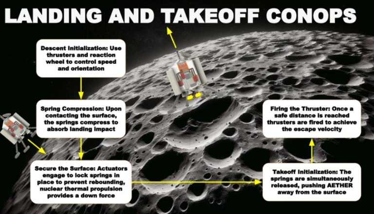
At the core of the AETHER project is a combination of three critical technologies that work in unison to enable prolonged and efficient exploration. The first is a spring-loaded landing system that allows the robot to land gently on the weak gravitational fields of asteroids. By transferring some of the energy from the landing into stored energy, the robot can later use this reserve to launch itself back into space.

The second technology is a metal-burning rocket engine. This innovative engine is designed to burn aluminum, a common metal found on many asteroids, and convert it into thrust. The robot uses this method to hop from one asteroid to another, making inter-asteroid travel both efficient and sustainable.

The third major component is the KRUSTY reactor, a kilowatt-class nuclear reactor that has undergone extensive testing by both NASA and the Department of Energy. This reactor provides the continuous power needed for the robot’s systems, ensuring that its operations are not limited by conventional fuel supplies.

Project Components

Below is a table summarizing the key components of the AETHER project:
Component Description
Spring-Loaded Landing Enables soft landings and recaptures energy during the landing process
Metal-Burning Engine Burns harvested aluminum to produce thrust for inter-asteroid travel
KRUSTY Reactor Provides a reliable nuclear power source for prolonged operations
Machine Learning Optimizes resource harvesting and landing site selection using sensor data

The integration of these components creates a robust platform that not only travels between asteroids but also refuels itself by harvesting local resources. This design is particularly significant as it could lead to missions that continue indefinitely, exploiting the abundant resources in the asteroid belt.

Technology in Detail

The spring-loaded landing mechanism is a key innovation in this design. Asteroids have extremely weak gravitational forces, meaning that traditional landing methods used on planets would be ineffective. The spring-loaded system absorbs the impact energy during landing and then reuses that energy to help launch the probe for its next journey. This method reduces mechanical stress on the probe and ensures a gentle touch on the asteroid’s surface.

The metal-burning engine is equally revolutionary. Instead of relying on conventional chemical fuels, this engine uses materials found on the asteroid itself. The robot is equipped with tools to extract water and aluminum from the asteroid’s surface. The water is split into hydrogen and oxygen, and the aluminum is burned to create the high-delta-v propulsion needed for rapid travel. This ingenious use of in-situ resources minimizes the need for carrying fuel from Earth, significantly lowering mission costs and increasing mission longevity.

Furthermore, the AETHER system employs machine learning algorithms that process data from various sensors such as synthetic aperture radar and spectrometers. This data is critical in determining the best landing sites for refueling and resource collection. The probe communicates its findings back to Earth via a high-speed optical link, allowing ground-based experts to update the machine learning parameters for future hops.

Mission Objectives and Targets

The initial mission design for AETHER includes planned stops at two specific asteroids before venturing into unknown territories. The first target is Psyche, a large metallic asteroid known for its high concentration of metals, including aluminum. Data gathered from a dedicated probe visiting Psyche will be instrumental in refining AETHER’s resource-harvesting algorithms.

The second target is Themis, a smaller asteroid that is believed to contain significant amounts of water ice. Water is essential for the probe’s fuel production, and Themis serves as a critical refueling station for the mission. After completing these initial visits, the probe could potentially operate indefinitely by continuously extracting resources from successive asteroids.

Below is a table that compares the resources available on the primary target asteroids:
Asteroid Primary Resource Notable Feature
Psyche Metal (Aluminum) High concentration of valuable metals
Themis Water Ice Critical for in-situ fuel production

The success of these missions would not only prove the viability of the AETHER project but also demonstrate a sustainable model for asteroid belt exploration.

Advantages and Challenges

The advantages of this approach are numerous. The self-sustaining design allows for missions that are not heavily dependent on Earth-based resupply. The integration of machine learning ensures that the probe adapts to the conditions of each asteroid, enhancing its resource extraction efficiency. Moreover, the innovative propulsion system opens up possibilities for rapid, high-delta-v travel within the asteroid belt.

Despite these benefits, the project faces significant challenges. Engineering a system that can reliably land, refuel, and take off in the unpredictable environment of the asteroid belt is a complex task. The technology must withstand extreme temperature variations, radiation, and the mechanical stresses of repeated landings and launches. Moreover, ensuring precise communication with Earth over vast distances requires robust optical systems and data processing capabilities.

The collaborative efforts between various space agencies, academic institutions, and private companies are essential to overcome these hurdles. Continued research and testing, such as those documented in the NASA-funded reactor development, are paving the way for the eventual success of projects like AETHER.

Future Implications

The potential implications of the AETHER project extend far beyond mere asteroid exploration. By creating a self-sustaining probe, this project sets the stage for future missions that could tap into the vast resources of the solar system. The principles behind AETHER could eventually lead to the development of fleets of autonomous probes, revolutionizing our approach to space mining and resource extraction.

Furthermore, the technological advancements made through this project are likely to have broader applications in robotics, artificial intelligence, and nuclear reactor technology. The integration of these diverse fields highlights the interdisciplinary nature of modern aerospace engineering. For more detailed insights into similar cutting-edge projects, see the article on miniaturized jumping robots.

The AETHER project represents a bold step forward in the realm of space exploration. Its unique combination of a spring-loaded landing system, metal-burning engine, and the KRUSTY nuclear reactor provides a glimpse into the future of inter-asteroid travel. With its ability to harvest local resources and its adaptive machine learning system, AETHER is poised to operate well beyond its initial mission objectives, potentially exploring the asteroid belt almost indefinitely.

This innovative design not only echoes the pioneering concepts of self-replicating probes but also offers a practical solution for sustainable space exploration. As the project continues to evolve, it may very well serve as a cornerstone for humanity’s next great leap into the cosmos. For further details on the technical aspects and mission design, refer to the AETHER technical paper and additional resources.

Fun Facts

  • The asteroid belt is located between Mars and Jupiter.
  • Aluminum is one of the most abundant metals in the solar system.
  • The concept of a self-sustaining probe has been studied for decades.
  • UT Austin has a strong legacy of innovation in aerospace research.
  • The KRUSTY reactor has been tested by both NASA and the Department of Energy.

References

Scientists Reveal Why Martian Soil is Extra Crusty

Recent findings from NASA’s InSight mission reveal that Martian soil is hardened by salty films, formed due to temperature changes on Mars. These crusty layers are vital to understanding the soil’s composition, which affects heat flow and could influence potential microbial life.

Summary

  • InSight mission on Mars provided new insights into Martian soil through the Heat Flow and Physical Properties Package (HP3), or “Mars Mole.”
  • The HP3 instrument, though limited in depth, analyzed thermal properties in the Martian soil, highlighting why it is so hard to penetrate.
  • Researchers discovered that temperature cycles on Mars create salt films, leading to a crusty layer in the soil.
  • This crusty layer (duricrust) is located just beneath the surface, affecting heat flow and soil properties.
  • Thermal measurements showed that the soil density near the surface is comparable to basaltic sand.
  • Findings may impact future Mars missions, as they indicate a level of insulation in the soil that could influence temperature-sensitive processes.
  • Temperature variations near the surface could enable the formation of salty brines, which has implications for the survival of microbial life.
  • The duricrust could pose challenges for exploration tools meant to dig beneath Mars’s surface.
  • Insights into Martian soil contribute to theories on Mars’s geological history and heat retention.
  • Understanding Martian soil could support future missions to Mars, including potential human exploration.
Scientists Reveal Why Martian Soil is Extra Crusty
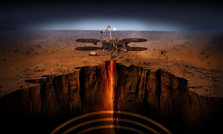
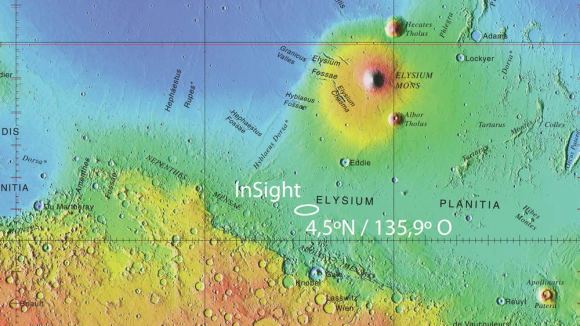
NASA’s InSight spacecraft landed in the Elysium Planitia region on Mars. This happened on November 26, 2018. NASA is the United States’ space agency. The spacecraft is a vehicle designed to travel in outer space. Elysium Planitia is a flat area on Mars. It is located near the planet’s equator. Credit goes to NASA-JPL, USGS, MOLA, and DLR for their contributions. These organizations worked together to make this mission possible.

Introduction: Understanding the Martian Soil

Mars, the Red Planet, has long fascinated scientists and explorers. With its barren surface and extreme conditions, Mars is a challenging environment for exploration. NASA’s InSight mission, launched in 2018, marked a significant achievement by placing a research station on Mars dedicated to studying its subsurface. Equipped with advanced instruments, InSight aimed to collect data on Mars’s interior and provide insight into the planet’s geologic activity.

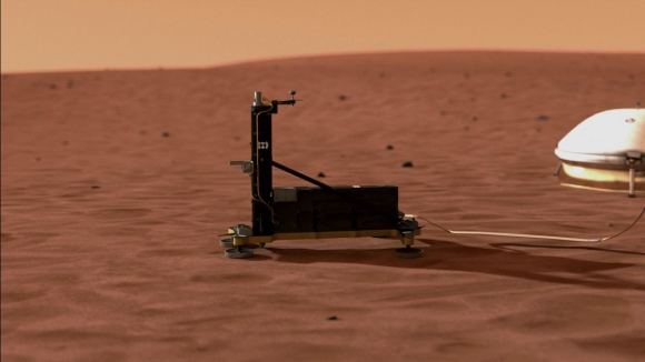
One of the primary tools used by InSight is the Heat Flow and Physical Properties Package (HP3), also known as the Mars Mole, developed by the German Aerospace Center (DLR). HP3’s objective was to dig deep into the Martian surface and measure heat flow from inside the planet, which would aid in understanding Mars’s thermal properties. Despite the unexpected difficulties faced by HP3 in penetrating the surface, scientists gathered valuable data, unveiling new insights into Martian soil’s unique properties.

Key Discoveries from the HP3 Mars Mole

The HP3 probe was designed to dig as deep as five meters, but it struggled to reach more than a few centimeters below the surface. Instead of reaching its intended depth, it managed to burrow only 40 cm (about 16 inches) into the soil. This limitation, however, yielded a surprising discovery about the Martian surface: a crusty layer formed by salty brines hardened the soil.

Thermal Properties of Martian Soil

The data collected by HP3 allowed scientists to analyze thermal conductivity and soil density on Mars. By comparing subsurface temperatures recorded by InSight with surface temperatures, scientists measured the thermal diffusivity and thermal conductivity of Martian soil. This data has been crucial for understanding Mars’s thermal environment.

“The thermal conductivity data we obtained provided a valuable look into the physical properties of Martian soil, even though we were unable to dig as deep as originally intended,” explained Tilman Spohn, Principal Investigator for the HP3 experiment at the DLR Institute of Planetary Research.

Why is Martian Soil So Crusty?

1. Formation of Salt Films in Martian Soil

The research conducted by the DLR team shows that temperature fluctuations in the top 40 cm of Mars’s surface lead to the formation of salt films. These salty films, formed when there’s enough moisture, harden the soil and create a crust-like layer. This encrusted soil, also called duricrust, likely consists of salty brines solidifying beneath the surface during cold Martian nights.

2. Seasonal and Daily Temperature Cycles

On Mars, surface temperatures fluctuate significantly due to its thin atmosphere and distant position from the Sun. During the day, temperatures can rise dramatically, only to plummet at night. According to data, Martian soil temperatures just below the surface shift between -56°C and -60°C daily. Although temperature cycles impact surface and near-surface soil, they stabilize at greater depths, leading to variations that encourage brine formation.

Measurement Temperature (°C) Temperature (°F)
Daytime Surface Temperature -56 -68.8
Nighttime Surface Temperature -60 -76
Average Near-Surface Temperature -58 -72.4

These temperature shifts cause salts in the soil to absorb moisture from the atmosphere, forming brine during specific seasons. The brine subsequently hardens, creating a crusty surface layer resistant to digging and drilling.

Martian Soil’s Composition and Density

The soil density on Mars’s surface layer has surprised scientists. By comparing HP3’s measurements with known earth materials, researchers deduced that the top 30 cm (~12 inches) of soil resemble basaltic sand, which commonly forms through volcanic activity. Beneath this layer lies a denser, more consolidated soil, likely made of coarse basalt fragments.

Martian Soil Depth Material Density Comparison
0-30 cm (~12 in) Basaltic Sand Similar to Earth’s sand
30-50 cm (~20 in) Consolidated Coarse Fragments Harder, resistant layer

This stratification affects how heat is transferred and stored, which could play a key role in the stability and behavior of Martian soil, especially when considering its interaction with temperature cycles and potential drilling operations for future Mars missions.

Scientists Reveal Why Martian Soil is Extra Crusty
The “Mars Mole” is known as the Heat Flow and Physical Properties Package (HP³). This is a scientific instrument. It measures heat flow and physical properties on Mars. The German Aerospace Center, also called DLR, designed the Mars Mole.

Implications for Future Mars Missions

1. Geological Activity and Thermal Insulation

The Martian soil’s crusty layer acts as an insulator, moderating temperature fluctuations below the surface. This insulation could suggest that Mars retains some geological activity, although at a much slower rate than Earth. With these findings, scientists believe that the Martian core may still possess a degree of thermal activity.

2. Potential for Microbial Life

The crusty soil layer may also impact any search for microbial life. The formation of salty brines near the surface provides an environment where life, if it exists, could potentially survive. Even with extreme surface conditions, the protected soil layer may contain the right conditions for microbial life, especially if future missions discover water or hydrated minerals.

“Temperature has a strong influence on chemical reactions occurring in the soil, on the exchange with gas molecules in the atmosphere, and therefore also on potential biological processes regarding possible microbial life on Mars,” said Spohn, highlighting the relevance of these findings.

3. Soil Hardness and Exploration Challenges

The crusty layer poses a technical challenge for drilling and sampling tools on Mars. As HP3 demonstrated, penetrating the duricrust layer requires tools equipped to handle hardened soil. Future missions to Mars will need to develop more advanced tools that can break through this crust and access deeper layers. Insights from HP3’s challenges could lead to more effective drilling technology for human missions.

4. Scientific Implications for Mars’s Geological History

The duricrust layer offers a window into Mars’s past. Scientists speculate that Mars’s geological activity may have significantly diminished during the Hesperian period, about 3 billion years ago. This period is characterized by reduced volcanic activity and cooling of the Martian core. Evidence from the HP3 data supports theories that Mars’s outer core solidified due to its smaller size and mass compared to Earth, potentially impacting the planet’s geological evolution and surface conditions.

Facts About Mars’s Crusty Soil

  • The duricrust layer on Mars might extend to about 20 cm (~8 inches) beneath the surface, hardened by salty brines that form seasonally.
  • Unlike Earth, Mars lacks an ozone layer, so UV radiation can penetrate the surface. This might affect the soil’s chemical composition.
  • Basaltic sand on Mars, found near the surface, is similar to volcanic sand on Earth, possibly formed from ancient volcanic activity.
  • Due to Mars’s thin atmosphere, temperature variations are extreme, but the soil’s crusty layer helps stabilize temperatures beneath the surface.
  • The crusty layer of soil could be an indicator of past hydrological activity on Mars, pointing to water’s role in shaping the planet’s surface.

NASA’s InSight mission has provided valuable data that reshapes our understanding of Martian soil. The discovery of the crusty duricrust layer, formed by salty films, reveals how temperature cycles shape Mars’s surface. While the HP3 instrument faced challenges, its findings are crucial for future Mars exploration, offering insights into the challenges posed by the Martian soil.

Understanding Martian soil’s density, thermal properties, and insulating capabilities will be vital for future missions, especially those involving drilling or human exploration. As scientists continue to analyze data from the InSight mission, they may uncover even more about Mars’s geological history, surface conditions, and the planet’s potential to support life.

References

#MarsExploration, #NASA, #InSight, #MartianSoil, #SpaceScience, #Astrobiology, #PlanetaryGeology, #Duricrust, #HeatFlow, #HP3, #SpaceMissions, #Mars, #Exploration, #ScientificResearch, #FutureExploration, #MicrobialLife

Russia Activates World’s First Satellite System for Arctic Monitoring

Key Takeaway

Russia has launched the world’s first dedicated Arctic observation satellite system, aimed at providing round-the-clock monitoring of the Arctic region, supporting navigation and shipping along the Northern Sea Route, as well as facilitating hydrocarbon exploration.

Summary

  • Over the weekend, Russia activated the world’s first Arctic observation satellite system, drawing data from the two Arktika-M satellites launched in 2021 and 2022.
  • The new satellite constellation provides continuous meteorological and environmental monitoring of the Arctic surface and the Northern Sea Route.
  • Russia has created a hydro-meteorological space system that allows permanent observation of the Arctic regions and its adjacent territories, a first in the world.
  • The complete Arktika mission constellation is planned to eventually have 10 Earth-orbiting satellites, including communication, GPS, commercial, and remote sensing satellites.
  • The satellites will be placed in a Highly Elliptical Orbit (HEO), ensuring full-time coverage of the high latitudes, which is not provided by existing international geostationary satellites.
  • The Arktika system will also be used for hydrocarbon exploration, aligning with Russia’s ambition to intensify exploitation of the Arctic’s oil and gas resources.
  • Importantly, the space system will provide telecommunications services in the Arctic, which Russia needs for air traffic and commercial shipping in the remote region.
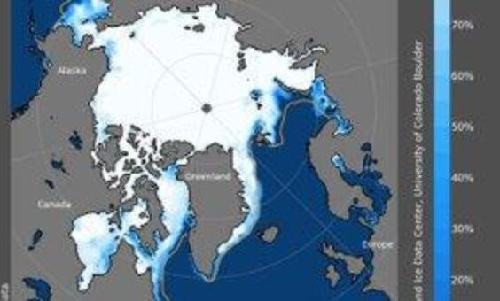
  • Russia has heavily invested in the development of the Northern Sea Route, hoping it could become an alternative shipping route as sea ice in the Arctic recedes, shortening the distance between the Far East and the West compared to the Suez Canal route.

Russia Activates World's First Satellite System for Arctic Monitoring

Russia Activates World’s First Satellite System for Arctic Monitoring

In a bold move to assert its dominance in the Arctic region, Russia has launched the world’s first dedicated Arctic observation satellite system. This groundbreaking initiative aims to provide round-the-clock monitoring of the vast and rapidly changing Arctic landscape, supporting navigation and shipping along the strategic Northern Sea Route, as well as facilitating hydrocarbon exploration.

The Arctic has long been a region of intense interest and competition among nations, driven by its vast untapped natural resources and the potential for new shipping routes as sea ice melts due to climate change. Russia, with its extensive Arctic coastline, has consistently sought to strengthen its presence and control in this strategic area.

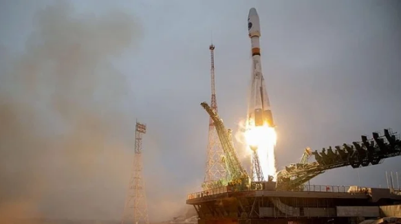
Over the weekend, Russia activated its Arctic observation satellite system, drawing data from the two Arktika-M satellites launched in 2021 and 2022. This new constellation provides continuous meteorological and environmental monitoring of the Arctic surface and the Northern Sea Route, a crucial shipping lane that Russia hopes will become a viable alternative to the Suez Canal route.

The complete Arktika mission constellation is planned to eventually have 10 Earth-orbiting satellites, including communication, GPS, commercial, and remote sensing satellites. These satellites will be placed in a Highly Elliptical Orbit (HEO), ensuring full-time coverage of the high latitudes, which is not provided by existing international geostationary satellites.

One of the key objectives of the Arktika system is to facilitate hydrocarbon exploration in the Arctic, aligning with Russia’s ambition to intensify the exploitation of the region’s oil and gas resources. Additionally, the space system will provide crucial telecommunications services in the Arctic, essential for air traffic and commercial shipping in this remote and challenging environment.

Russia has heavily invested in the development of the Northern Sea Route, a shipping lane that runs along the Siberian coastline. As sea ice in the Arctic continues to recede due to climate change, Russia hopes that this route could become a viable alternative to the Suez Canal, significantly shortening the distance between the Far East and the West.

While Russia’s Arctic ambitions are undoubtedly bold, they also raise concerns about the potential environmental impact of increased economic activity in the fragile Arctic ecosystem. Additionally, the militarization of the region and the potential for conflicts over territorial claims and resource extraction rights remain ongoing issues.

Despite these challenges, Russia’s commitment to advancing its Arctic capabilities is clear. The launch of the world’s first dedicated Arctic observation satellite system represents a significant technological and strategic milestone, positioning Russia as a leader in this rapidly evolving frontier.

HASHTAGS:

#Arctic, #Russia, #Satellites, #NorthernSeaRoute, #Exploration, #ClimateChange, #Shipping, #RemoteSensing, #Telecommunication, #SpaceTechnology

Source: teleSUR English Link: Read more

How Many Stars Exist in the Universe?

Key Takeaway

The Universe contains an astonishingly large number of stars, estimated to be between 10^22 to 10^24 stars, gathered into billions of galaxies, with our Milky Way galaxy alone containing about 100 billion stars. Attempting to count the stars in the universe has been likened to trying to count the grains of sand on a beach on Earth. Just as we might estimate the number of sand grains by measuring the surface area and depth of the beach, astronomers employ ingenious methods to approximate the number of stars.

Summary

  • The number of stars in the Universe has been a subject of fascination for scientists, philosophers, and dreamers throughout history.
  • With the naked eye, a few thousand stars are visible on a clear night, but even modest telescopes reveal millions more.
  • Stars are not scattered randomly but are grouped into vast galaxies, with our Milky Way galaxy alone estimated to contain about 100 billion stars.
  • There are millions upon millions of other galaxies in the Universe, each containing billions of stars.
  • A rough estimate suggests there could be between 10^22 to 10^24 stars in the entire Universe, although this is an approximation as galaxies vary in size and number of stars.
  • Counting individual stars is impractical; instead, scientists measure integrated quantities like the number and luminosity of galaxies.
  • ESA’s Herschel space observatory contributed by ‘counting’ galaxies in the infrared and measuring their luminosity in this range, providing insight into star formation rates.
  • Herschel revealed that early star formation was hidden by thick dust clouds, which block visible light but emit infrared radiation, indicating more stars than previously thought.
  • The Hubble Space Telescope suggested a peak in star formation around 7 billion years ago, but infrared observations from Herschel revealed more stars forming in the early Universe.
  • The Gaia mission is studying one billion stars in the Milky Way, charting their positions, distances, movements, and brightness changes, building an unprecedented picture of our Galaxy’s structure and evolution.
  • Missions like Herschel, Hubble, Hipparcos, and Gaia are helping astronomers refine their estimates of the total number of stars in the Universe.

How Many Stars Exist in the Universe

Uncovering the Mind-Boggling Number of Stars in the Universe

When we gaze up at the night sky, the twinkling stars seem countless, yet they represent merely a fraction of what the cosmos truly harbors. For centuries, the enigma of quantifying the stars has captured the imagination of scientists, philosophers, and dreamers alike.

Imagine standing under a dark, pristine sky, away from the artificial glow of city lights. With the naked eye, you can discern a few thousand shimmering stars, each a celestial beacon in the vast expanse. However, this is merely the tip of the iceberg. Even modest amateur telescopes reveal millions more, hinting at the unimaginable vastness that awaits beyond our limited perceptions.

Stars are not scattered randomly throughout the universe; instead, they congregate into vast, gravitationally bound structures called galaxies. Our cosmic home, the Milky Way, is one such galaxy, and it alone is estimated to harbor a staggering 100 billion stars. But the Milky Way is merely a speck in the grand fabric of the universe, for it is accompanied by millions upon millions of other galaxies, each a colossal metropolis of stars in its own right.

Attempting to count the stars in the universe has been likened to trying to count the grains of sand on a beach on Earth. Just as we might estimate the number of sand grains by measuring the surface area and depth of the beach, astronomers employ ingenious methods to approximate the number of stars.

By studying a representative sample of galaxies and extrapolating their star counts, scientists have arrived at a mind-boggling estimate: the universe could contain anywhere between 10^22 to 10^24 stars. This range, covering from a trillion trillion to a quadrillion trillion stars, is a testament to the sheer immensity of the cosmos and the limitations of our comprehension.

One of the challenges in accurately estimating the number of stars lies in the obscuring effects of cosmic dust. These opaque clouds, composed of gas and microscopic particles, can block the visible light emitted by stars, rendering them invisible to telescopes operating in the optical wavelengths.

Enter the Herschel Space Observatory, a pioneering infrared telescope launched by the European Space Agency (ESA). By observing in the infrared spectrum, Herschel could peer through the veil of cosmic dust, unveiling a hidden universe of stars that had remained elusive to previous telescopes.

Herschel’s groundbreaking observations revealed that early star formation was more prolific than previously thought, with thick dust clouds obscuring much of the stellar activity in the universe’s younger epochs. This newfound insight challenged the notion that star formation peaked around 7 billion years ago, as suggested by the iconic Hubble Deep Field image.

While space telescopes like Herschel and Hubble have expanded our understanding of the universe’s stellar populations, the Gaia mission focuses its gaze closer to home, studying one billion stars within our galactic neighborhood, the Milky Way.

Launched in 2013, Gaia is meticulously charting the positions, distances, movements, and brightness changes of these stars, building an unprecedented map of our galaxy’s structure and evolution. By precisely tracking each of its one billion target stars multiple times during its mission, Gaia is providing astronomers with invaluable data to unravel the mysteries of our cosmic home and refine our estimates of its stellar inhabitants.

As we stand on the shoulders of these groundbreaking space missions, we inch closer to answering the age-old question: “How many stars are there in the universe?” Yet, with each new discovery, the cosmos reveals itself to be more vast, more complex, and more awe-inspiring than we ever imagined.

The astonishing estimates of stars in the universe not only challenge our comprehension but also ignite a sense of wonder and humility within us. We are but tiny specks in a cosmos teeming with uncountable celestial beacons, each a potential harbinger of life, and each a testament to the greatness and majesty of the universe we call home.

HASHTAGS:

#astronomy, #universe, #stars, #galaxies, #cosmology, #space, #science, #exploration, #wonders, #vastness, #MilkyWay, #Herschel, #Hubble, #Gaia, #HubbleDeepField #How Many Stars Exist in the Universe?

Source: ESA – European Space Agency Link: Read more

Pin It
error: Content is protected !!

This website utilizes first- and third-party tools that store small files (cookies) on your device. These cookies serve various purposes, including ensuring the site functions correctly (technical cookies), analyzing site usage (analytics cookies), and delivering relevant advertisements (profiling cookies). While technical cookies are essential and used by default, you have the option to enable or disable analytics and profiling cookies. By allowing these cookies, you help us enhance your browsing experience.