Tag

#EarthScience

Browsing

Earth Bombarded by Moon Debris: 1 in 4 Ejecta Makes the Trip

A recent high-precision simulation study finds that 22.6% of material blasted off the Moon by impacts eventually collides with Earth—half of those impacts happen within the first 10,000 years. This work reveals new patterns in how lunar debris travels through space, showing an equatorial concentration on Earth, a strong dependence on where on the Moon the debris was launched, and a small but measurable contribution of lunar fragments to the near-Earth object population. These insights reshape our understanding of Earth–Moon material exchange and have implications for planetary science, meteoroid hazard assessment, and the origin of certain near-Earth asteroids.

Summary

  • The Moon’s surface preserves billions of years of impact history due to its lack of atmosphere and geological reshaping.
  • Large impacts can eject material at speeds exceeding lunar escape velocity (2.38 km/s).
  • Researchers used the REBOUND N-body simulation package with the IAS15 integrator to track 6,000 test particles for 100,000 years.
  • Ejecta fragments modeled were tens of meters in size, reflecting realistic crater-forming impacts.
  • 22.6% of all simulated lunar ejecta fragments collided with Earth over the 100,000-year timeframe.
  • Half of those collisions occurred within the first 10,000 years after ejection.
  • The collision rate follows a power-law decay C(t)∝t0.315C(t)\propto t^{0.315}.
  • Debris launched from the Moon’s trailing hemisphere has the highest probability of hitting Earth.
  • Fragments from the leading hemisphere are least likely to reach Earth.
  • Impact speeds upon Earth arrival average 11.0–13.1 km/s.
  • Impacts concentrate near the equator, with 24% fewer at the poles.
  • Arrival times are nearly symmetrically split between local morning and evening, peaking around 6 AM/PM local time.
  • A small fraction of ejecta remains in Earth co-orbital orbits, possibly feeding the near-Earth object (NEO) population.
  • Objects such as Kamo’oalewa and 2024 PT5 may be examples of lunar fragments in quasi-satellite orbits.
  • Understanding lunar ejecta dynamics helps reconstruct Earth’s impact history and assess meteoroid hazards.
Earth Bombarded by Moon Debris 1 in 4 Ejecta Makes the Trip
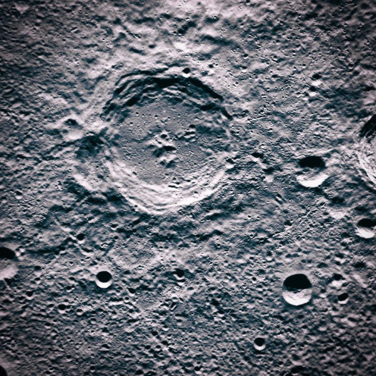
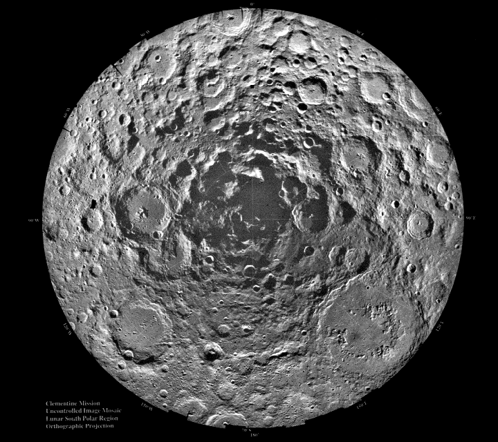
NASA shares a picture of moon holes near the South Pole.

Introduction

The lunar surface is a time capsule of Solar System history. Without an atmosphere or active plate tectonics, impact craters remain preserved for billions of years, recording the intensity of bombardment during events like the Late Heavy Bombardment approximately 4 billion years ago. Each large impact excavates and ejects material, some of which attains velocities above the Moon’s escape velocity (2.38 km/s) and embarks on trajectories through cislunar space. Understanding how much of this debris reaches Earth informs our knowledge of planetary evolution, meteoroid fluxes, and even the delivery of volatile or organic materials to our planet.

Early work by Gault (1983) estimated that only about 0.5% of lunar ejecta strikes Earth, with an average accretion rate of 10–100 million grams per year. Later studies improved modeling fidelity but often treated geocentric and heliocentric phases separately. The recent study by Castro-Cisneros, Malhotra, and Rosengren integrates both phases continuously, uses a realistic ejecta velocity distribution, and extends simulations to 100,000 years, providing the most comprehensive estimate to date of the lunar ejecta flux to Earth.

Simulation Methods

The research team employed the REBOUND N-body code with the high-accuracy IAS15 integrator to simulate the trajectories of 6,000 test particles representing lunar ejecta fragments. Key aspects of their methodology include:

Parameter Description
Simulation duration 100,000 years
Number of test particles 6,000
Ejection velocity distribution Physically motivated, tens of m-sized fragments
Launch locations Various lunar latitudes/longitudes (leading & trailing hemispheres)
Gravitational bodies included Sun, Earth, Moon, and all major planets
Data recording interval Every 5 years

By modeling all gravitational influences simultaneously and using realistic velocity distributions from large cratering events, the team overcame limitations of prior two-phase studies.

Results

The simulation yielded several key findings:

Collision Probability and Timing
The total fraction of ejecta colliding with Earth over 100,000 years is 22.6%. The collision rate C(t)C(t) follows a power-law decay, C(t)∝t0.315C(t)\propto t^{0.315}, indicating most impacts occur early. Indeed, half of all collisions happen within the first 10,000 years after ejection arXiv.

Launch Hemisphere Dependence
Material launched from the Moon’s trailing hemisphere (the side opposite the direction of orbital motion) exhibits the highest Earth-collision probability, while fragments from the leading hemisphere show the lowest probability.

Launch Hemisphere Earth Collision Probability (%)
Trailing 28.4
Equatorial 21.7
Polar 18.0
Leading 15.2

Impact Velocities and Geographic Distribution
Upon arrival, lunar ejecta strikes Earth at velocities between 11.0 km/s and 13.1 km/s. Impacts preferentially occur near the equator, with a 24% decrease in frequency toward the poles. The timing of impacts is nearly symmetric between local morning and evening, peaking around 6 AM/PM local time arXiv.

Implications for Planetary Science

Understanding the lunar ejecta flux has multiple implications:

  1. Reconstructing Earth’s Impact History
    Lunar craters serve as a proxy for Earth’s early bombardment record. By quantifying how much lunar debris returns to Earth, scientists can better correlate lunar crater ages with terrestrial impact deposits, improving timelines of events that may have influenced geological and biological evolution.

  2. Contribution to Near-Earth Objects (NEOs)
    A minor fraction of lunar ejecta remains in co-orbital orbits for extended periods. Objects such as Kamo’oalewa (2016 HO3) and 2024 PT5 exhibit spectral signatures matching lunar material, suggesting a lunar origin. These fragments represent a hitherto underappreciated source of small NEOs.

  3. Meteoroid Hazard Assessment
    Impact velocities of 11–13 km/s pose significant energy upon collision. Knowing the frequency and velocity distribution of lunar ejecta helps refine risk models for both Earth and spacecraft in cislunar space.

  4. Sample Return Opportunities
    Quasi-satellite lunar fragments offer accessible targets for missions seeking pristine lunar material without landing on the Moon. Their study could reveal new information about lunar geology and impact processes.

Future Research Directions

  • Oblique Impact Modeling: Incorporate non-vertical impacts to assess how lower-angle ejections alter Earth-bound flux.
  • Ancient Orbital Configurations: Simulate when the Moon was closer to Earth and bombardment rates were higher, to estimate historical ejecta transfer.
  • Size Distribution Effects: Extend models to different fragment sizes, from dust to boulder scale, to understand how size influences transfer efficiency.
  • Spectral Surveys: Identify more lunar-origin NEO candidates via spectral matching, expanding the sample of known lunar fragments in Earth orbit.
  • Sample Missions: Plan missions to quasi-satellites like Kamo’oalewa for direct sampling of lunar ejecta.

This study fundamentally revises our understanding of how much lunar material makes its way back to Earth. By demonstrating that nearly one in four ejecta fragments eventually collide with our planet—and that half do so within 10,000 years—it highlights a dynamic exchange that has shaped both lunar and terrestrial surfaces. The equatorial bias, velocity distribution, and launch-hemisphere dependence provide new parameters for modeling impact fluxes and assessing hazards. Moreover, the identification of potential lunar fragments among NEOs opens exciting avenues for future exploration and sample return.

Facts

  • The Moon’s escape velocity is only 2.38 km/s, compared to Earth’s 11.2 km/s.
  • Some lunar ejecta fragments spend tens of thousands of years orbiting the Sun before hitting Earth.
  • Meteorites found on Earth that originate from the Moon are called “lunar meteorites.”
  • The largest known lunar crater, South Pole–Aitken Basin, is over 2,000 km across.
  • Earth receives hundreds of tons of meteoritic material daily, but only a small fraction comes from the Moon.

References

  • Castro-Cisneros, J. D., Malhotra, R., & Rosengren, A. J. (2025). Lunar impact ejecta flux on the Earth. arXiv:2504.15502. arXiv
  • Investigation of lunar ejecta dynamics: particles reaching the near Earth. A&A. A&A
  • Gladman, B., et al. (1995). The dynamical evolution of lunar impact ejecta. Icarus, 118, 302–321. ADS
  • Gault, D. E. (1983). Accretion rate of lunar ejecta onto Earth. JGR, 88, A31–A35. A&A
  • NASA Lunar Reconnaissance Orbiter observations of meteoroid impacts. NASA Release 16-33. NASA
  • University of Arizona study on lunar fragment Kamo’oalewa. EurekAlert! EurekAlert!
  • Sharkey, J., et al. (2021). Spectral analysis of Kamo’oalewa. AJ. PubMed
  • Mitchell, E. K., et al. (2024). Lunar ejecta origin of near-Earth asteroid Kamo’oalewa. Commun. Earth Environ. PubMed
  • Reuters (2024). Meteorite impacts drive Moon’s tenuous atmosphere. Reuters
  • Wired (2012). New NASA video depicts the Moon’s fiery history. WIRED

Bacteria That Mimic Multicellular Life: A Clue to How Life Evolved

Multicellular magnetotactic bacteria (MMB) are the only known bacteria that group together permanently, forming obligate multicellular consortia. Recent research shows these consortia are genetically diverse and exhibit metabolic specialization between their member cells, offering a unique window into the early steps of multicellular evolution on Earth.

Summary

  • MMB use Earth’s magnetic field to navigate, thanks to intracellular magnetosomes.
  • They form obligate multicellular aggregates of 15–86 cells that cannot survive alone.
  • Genomic studies reveal that cells within one consortium are not clonal but genetically heterogeneous.
  • Individual cells take on specialized metabolic roles, such as sulphate reduction or carbon storage.
  • MMB consortia are mixotrophic, combining different energy and carbon pathways.
  • Research was published in PLOS Biology and funded by NASA’s Exobiology program.
  • These bacteria resist cultivation, so most data come from culture‐independent methods and electron microscopy.
  • Knowing about MMB helps us see how basic groups of cells might have started complicated life.
Bacteria That Mimic Multicellular Life A Clue to How Life Evolved
The picture shows a close-up of MMB. Single cells are grouped around a center without cells. Every cell has a magnetosome, a small part inside that keeps iron safe in a fatty cover. The center has stuff outside cells, but no cells. Every cell stores power and building blocks. We don’t yet know what other things are inside MMB cells. Picture by George Schaible et al. from PLOS Biology 2024.

How Magnetotactic Bacteria Work

Multicellular magnetotactic bacteria navigate using magnetosomes, tiny iron‐rich organelles encased in lipid membranes. These magnetosomes line up in chains, acting like a compass needle that aligns with Earth’s magnetic field. By following magnetic field lines, MMB optimize their position in sediments where oxygen and sulfide gradients meet.

MMB are found in marine and freshwater sediments, but they are hard to grow in the lab. Scientists rely on advanced microscopy and single‐cell genomics to study them. In one study, researchers sequenced genomes from 22 individual MMB consortia, uncovering eight new species and revealing unexpected genetic diversity within each group.

The Unique Life Cycle

Unlike most bacteria, MMB have no free‐living single‐cell stage. From birth, they exist as part of a tight-knit consortium of up to 86 cells. These cells arrange themselves around a central, acellular compartment filled with extracellular matrix. Each cell has compartments for energy reserves and carbon storage.

Feature Single‐Celled Bacteria MMB Consortia
Unicellular Stage Always present Absent — always multicellular
Genetic Uniformity Clonal Heterogeneous within one consortium
Survival Alone Yes No
Magnetic Navigation Rare Universal via magnetosome chains
Metabolic Roles Generalist Specialized by cell subpopulations

Genetic Diversity in MMB

Genomic analyses show that cells within one consortium differ in their DNA sequences, challenging the idea that multicellular aggregates derive from identical clones PubMed. This diversity may help the consortium adapt to changing environments by partitioning tasks among member cells.

“To study the biology of these unique organisms in more detail, we use multiple culture‐independent approaches to analyze the genomics and physiology of MMB consortia at single‐cell resolution,” said George Schaible, lead author of the PLOS Biology study PLOS.

Bacteria That Mimic Multicellular Life A Clue to How Life Evolved
This picture has an MMB in A. B shows two MMB that might be splitting. C shows magnetosome chains inside single cells. George Schaible and others provided the picture. It comes from PLOS Biology 2024.

Evolutionary Implications

MMB consortia illustrate a possible early step toward true multicellularity. Scientists theorize three phases in the evolution of multicellular life:

  1. Adhesion: single cells stick together for shared benefits.
  2. Communication and cooperation: cells exchange signals and resources.
  3. Specialization: cells take on different tasks, becoming interdependent.
Evolution Phase Description
Cell Adhesion Cells aggregate for protection or resource sharing
Communication & Cooperation Chemical signaling enables group-level responses
Division of Labor Specialized functions arise, leading to true multicellularity

These phases mirror what is seen in MMB: cells adhere, communicate, and specialize in ways similar to the first steps that gave rise to plants, animals, and fungi.

Broader Impact on Ecology

The rise of multicellular life transformed Earth’s ecosystems. It created new ecological niches, altered the carbon and oxygen cycles, and drove evolutionary innovation. By revealing how simple multicellular groups function, MMB studies help us understand the origins of complex life and guide the search for life beyond Earth. NASA’s support of this research underscores its importance to astrobiology and the quest to find life on other planets.

Facts

  • MMB consortia can contain up to 86 cells.
  • The acellular center is filled with sticky extracellular matrix.
  • Magnetosomes are made of magnetite or greigite minerals.
  • Some MMB species glow under certain light due to unique pigments.
  • Cells communicate using tiny molecular signals.

References

Earth Crust Is Dripping Under the Midwest US – Scientists Make a Shocking Discovery

New studies of earthquakes showed that something is happening under the middle of the US. Parts of the Earth’s crust deep down are falling into the layer below. This find helps us understand how the Earth changes and how land masses take shape.

Summary

  • Seismic data reveals the Earth’s crust is “dripping” beneath the Midwest US.
  • This process, termed lithospheric dripping, involves the sinking of the lower crust into the mantle.
  • The phenomenon is observed in other regions globally, indicating a common geological process.
  • The study enhances understanding of continental formation, deformation, and recycling.
  • The research was conducted by a team led by seismologist Junlin Hua.
  • The findings were published in Nature Geoscience.
  • The study utilized seismic data from the EarthScope Consortium.
  • The research indicates the North American craton is thinning due to lithospheric dripping.
  • The ancient Farallon tectonic plate’s subduction is influencing mantle flow beneath North America.
  • The process has been ongoing for hundreds of millions of years.
  • The study provides insights into the dynamic nature of Earth’s geological processes.
  • The findings have implications for understanding the stability and evolution of continental structures.
  • The research contributes to the broader field of geophysics and tectonics.
  • The study shows that watching for earthquakes is key to understanding what happens inside the Earth.
  • The discovery opens new avenues for future geological research.
Earth's Crust Is Dripping Under the Midwest US Scientists Make a Shocking Discovery
The leak happens right beneath the Midwest.

Introduction

Beneath the American Midwest, scientists have identified a remarkable geological process: the Earth’s crust is undergoing a phenomenon known as lithospheric dripping. This process involves portions of the lower crust becoming denser and sinking into the mantle, much like the slow formation and fall of drops in the famous pitch drop experiment. While this might sound alarming, it’s a natural occurrence that offers valuable insights into the Earth’s ever-changing interior.

Understanding Lithospheric Dripping

Lithospheric dripping occurs when the lower part of the Earth’s crust, or lithosphere, becomes unstable and detaches, sinking into the more fluid mantle below. This process can lead to surface deformations and has been observed in various regions worldwide, including the Andes and the Anatolian Plateau. In the case of the Midwest US, seismic data has revealed that the lithosphere is thinning, suggesting active dripping beneath the surface.

The Role of Cratons

This discovery focuses on a craton, a big, solid part of Earth’s surface that makes up the core of a continent. People used to think the North American craton, which sits under much of the continent, was very still. But new evidence shows that even these old formations change, possibly because of lithospheric dripping.

Seismic Investigations and Findings

The research team, led by seismologist Junlin Hua, utilized data from the EarthScope Consortium to construct detailed images of the subsurface. Their analysis revealed that the craton beneath the Midwest is thinning, with blobs of molten rock forming and descending into the mantle. This suggests that the lithosphere is not as immutable as once thought.

An intriguing aspect of this study is the role of the ancient Farallon tectonic plate. Approximately 600 kilometers from the craton, remnants of the subducted Farallon plate are interacting with mantle flows, exerting shear forces on the underside of the craton and contributing to its destabilization.

Earth's Crust Is Dripping Under the Midwest US Scientists Make a Shocking Discovery
Cracked and re-frozen blue ice on the river. Eastern Europe. Landscape. Background texture. Horizontal orientation.

While lithospheric dripping is a slow process occurring over millions of years, understanding it is crucial for comprehending continental evolution and stability. These findings not only reshape our understanding of the North American craton but also have broader implications for studying other cratonic regions worldwide.

Facts

  • The pitch drop experiment at the University of Queensland has been running since 1927 to observe the flow of a viscous substance over decades.
  • Cratons are among the oldest parts of the Earth’s crust, some dating back over 2 billion years.
  • The Farallon plate’s subduction has significantly influenced the geological development of western North America.​​

References

Sentinel-1C Satellite Successfully Launches Into Space: Advancing Earth Observation

The successful launch of Sentinel-1C on a VEGA-C rocket marks a significant advancement in Earth observation, enhancing our capacity to monitor climate change, respond to natural disasters, and manage land and sea resources. This satellite, part of the European Copernicus program, ensures continuous, high-quality data collection using cutting-edge radar technology, strengthening global environmental monitoring strategies.

Summary

  • Sentinel-1C launched successfully on a VEGA-C rocket and will orbit 700 km above the Earth.
  • Part of the European Copernicus programme, it employs advanced radar technology for all-weather, day-and-night imaging of Earth’s surface.
  • The satellite complements Sentinel-1A, forming a synchronized constellation for enhanced Earth observation capabilities.
  • Sentinel-1C supports critical applications like sea-ice monitoring, forest management, disaster response, and climate tracking.
  • The UK had a crucial role in creating essential parts. These parts included radar subsystems and batteries. Radar subsystems are parts of a system that helps detect objects using radio waves. Batteries are devices that store and provide electrical energy to power various equipment.
  • Airbus Defence and Space UK led the design and manufacture of radar electronic subsystems.
  • Sentinel-1C carries an Automatic Identification System (AIS) for ship collision avoidance and maritime surveillance.
  • This satellite bolsters long-term data collection for operational services rather than research purposes, ensuring reliable information for monitoring environmental changes.
  • Sentinel-1C data is crucial for governments, industries, and academics, offering actionable insights across diverse applications.
  • Copernicus satellites, including Sentinel-2C launched earlier, enable Europe and the UK to maintain leadership in global environmental monitoring.

Mission Overview and Launch Details

Sentinel-1C launched on the VEGA-C rocket. The launch took place at Europe’s Spaceport in French Guiana. Sentinel-1C reached an orbit 700 km above Earth. Its mission is to continue the Sentinel-1 mission. This mission started with Sentinel-1A, which launched in 2014. Both satellites will work together. They will provide continuous and complete Earth observation data.

The satellite is equipped with a Synthetic Aperture Radar (SAR), a highly advanced technology capable of capturing images of the Earth’s surface regardless of weather conditions or time of day. SAR’s versatility makes it invaluable for monitoring Arctic ice, detecting land movements, and assessing disaster impacts.

For further details about the Sentinel-1 mission, visit Sentinel Copernicus.

Role of the UK in Sentinel-1C Development

The UK played an important role in developing Sentinel-1C. Airbus Defence and Space in Portsmouth provided the electronics subsystem for the SAR instrument, while Enersys ABSL in Abingdon supplied the satellite’s battery.

Justin Byrne, Head of Earth Observation at Airbus UK, emphasized, “The UK has designed and manufactured radar electronics for the entire Sentinel-1 family, ensuring critical European satellite missions remain operational.”

The satellite exemplifies the UK’s commitment to Earth observation and innovation, supported by funding from the UK Space Agency. The nation’s contributions bolster the global impact of the Copernicus program and enhance its ability to deliver consistent, actionable data.

Sentinel-1C Satellite Successfully Launches Into Space Advancing Earth Observation

Applications and Benefits of Sentinel-1C

Sentinel-1C’s high-resolution radar data serves a broad range of applications, including:

Application Impact
Climate Change Monitoring Tracks sea ice extent, glacier motion, and other climate variables to assess global warming.
Disaster Response Provides real-time data for responding to floods, earthquakes, and volcanic eruptions.
Maritime Surveillance Tracks shipping routes, detects piracy, and enhances global maritime safety.
Agriculture and Forestry Monitors soil health, forest cover, and water resources to support sustainable practices.

The satellite’s Automatic Identification System (AIS) adds a new dimension to maritime safety by tracking vessels and detecting illegal activities like unregulated fishing and piracy. Learn more about Earth observation benefits at Innovation News Network.

Long-Term Data Collection for Climate Change

Unlike research satellites, Sentinel-1C is designed for operational service, ensuring consistent and reliable data for decades. Its capabilities are critical for addressing some of the world’s most pressing issues:

  • Land Motion Monitoring: Detects subtle ground movements in urban areas, enabling preventive measures against infrastructure failures.
  • Sea Ice and Oceanography: Tracks changes in Arctic and Antarctic ice, crucial for understanding the impacts of global warming.
  • Disaster Preparedness: Improves early warning systems for earthquakes and floods, saving lives and minimizing economic losses.

Dr. Chandra Taposeea-Fisher, Chair of the EO Committee at UKspace, explained, “Sentinel-1C’s data will empower communities and governments to make informed decisions about environmental conservation and disaster reduction.”

Technological Innovations

The SAR technology aboard Sentinel-1C is complemented by the newly integrated Automatic Identification System (AIS). This combination enables comprehensive monitoring of global maritime activities, from enhancing shipping efficiency to detecting environmental hazards like oil spills.

Professor Remedios emphasized the significance of operational radar satellites:
“The advent of radar satellites has revolutionized our ability to observe hazardous and extreme environments.”

This innovation aligns with the Copernicus programme’s mission to provide free, accessible data to scientists, governments, and industries worldwide.

Facts

  • Sentinel-1C can capture radar images through clouds and at night, unlike optical satellites.
  • The radar operates at C-band frequencies, enabling detailed surface mapping.
  • The satellite’s data archive will contribute to machine learning algorithms, further enhancing Earth observation research.

References

  1. How Earth Observation Satellite Data Is Used to Benefit Society
  2. Sentinel Copernicus: Sentinel-1
#Sentinel1C, #CopernicusProgramme, #EarthObservation, #ClimateChange, #MaritimeSafety, #SatelliteTechnology, #SARImaging, #GlobalMonitoring, #DisasterResponse, #UKSpaceIndustry, #Innovation, #EarthScience, #SpaceExploration, #RadarTechnology, #ClimateTracking

The Sound of Earth’s Magnetic Pole Reversal: A Fascinating Phenomenon

Earth’s magnetic pole reversals are captivating natural phenomena that shed light on the powerful magnetic forces deep within our planet. Though they’re rare and unpredictable, these reversals have profound implications for life on Earth and contribute to our understanding of geology, cosmic radiation, and ancient climate changes. With the help of the European Space Agency’s (ESA) Swarm mission, scientists have even recreated the eerie sounds of past reversals, making this invisible process almost tangible.

Summary

  • Earth’s magnetic field, responsible for protecting us from harmful cosmic radiation, occasionally undergoes a pole reversal.
  • Geomagnetic reversals switch the positions of the North and South magnetic poles.
  • These reversals happen on average every 450,000 years, but the timing is irregular.
  • The last full reversal was 780,000 years ago, suggesting we may be overdue.
  • Paleomagnetism in volcanic rocks reveals Earth’s history of pole reversals.
  • Magnetic pole reversals are chaotic events and can last thousands of years.
  • Excursions are temporary changes in the magnetic field and do not lead to full reversals.
  • During a reversal, Earth’s magnetic field weakens, exposing life to increased cosmic rays.
  • The Laschamps event was a recent magnetic excursion that weakened the magnetic field by 95%.
  • ESA’s Swarm mission recorded the sounds of magnetic changes, creating a haunting soundscape of the Laschamps event.
  • Scientists simulate the sounds of pole reversals using natural and alien-like sounds, adding a sensory dimension to the phenomenon.
  • The phenomenon holds implications for future reversals, scientific understanding, and technology.
  • Magnetic reversals also affect climate patterns, animal migration, and navigation systems.
  • ESA’s work on soundscapes provides a novel way to experience geomagnetic events.
  • The effects of magnetic reversals on human technology and biology require further research and preparation.

The Sound of Earth’s Magnetic Pole Reversal

When we think of Earth’s magnetic poles, we often imagine compasses aligning to the North Pole, guiding our navigation. However, beneath this everyday utility lies a complex and dynamic system. The North and South magnetic poles have not always remained stable in their positions; instead, they have flipped numerous times in Earth’s history in an event known as geomagnetic reversal. With recent research and audio technology, scientists have even attempted to recreate the sound of Earth’s magnetic field during these reversals, providing a fascinating auditory experience of this phenomenon.

What is a Geomagnetic Reversal?

A geomagnetic reversal is a complete flip of Earth’s magnetic poles, where the North Pole becomes the South Pole and vice versa. This reversal is neither quick nor orderly, typically taking thousands of years to complete. Although the poles change places about every 450,000 years, this is only an average; some intervals between reversals are significantly shorter or longer. According to the European Space Agency (ESA), Earth has experienced about 183 magnetic pole reversals in the past 83 million years. The last full reversal, the Brunhes-Matuyama reversal, happened approximately 780,000 years ago, meaning Earth could potentially be overdue for another flip.

Table 1: Key Differences Between Magnetic Reversal and Excursion

Feature Magnetic Reversal Magnetic Excursion
Duration Thousands to millions of years Hundreds to a few thousand years
Field Direction Completely reverses Temporarily shifts but returns to original orientation
Frequency Every ~450,000 years Irregular; happens more frequently
Field Strength Significantly weakened Partially weakened

Evidence of Magnetic Reversals

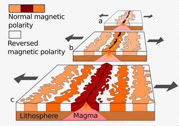
The evidence for magnetic pole reversals lies in a field known as paleomagnetism. When volcanic rocks cool, magnetic minerals within them align with Earth’s magnetic field. By analyzing the magnetic orientation of these rocks and determining their age, scientists can trace the history of Earth’s magnetic reversals. Magnetic stripes on the ocean floor, where new crust forms and records the magnetic field’s orientation, reveal patterns that point to past geomagnetic reversals. This record is invaluable for understanding Earth’s magnetic history and predicting future reversals.

The Laschamps Event: A Temporary Shift

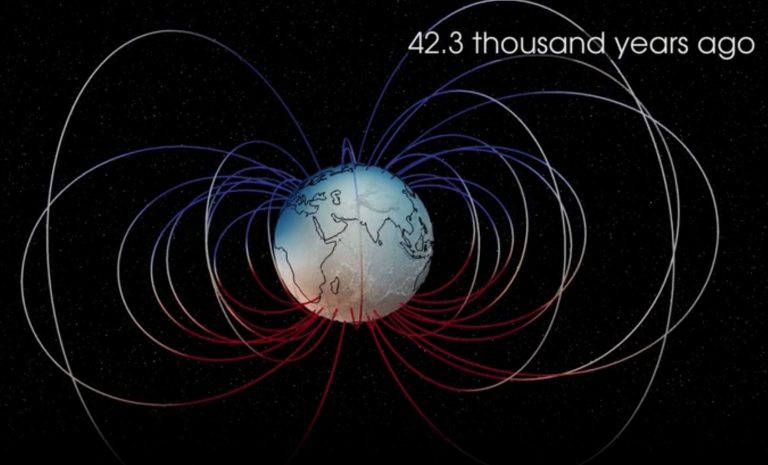
Not all magnetic field changes result in a complete pole reversal. Sometimes, the magnetic field temporarily weakens and shifts without fully reversing, an event known as a geomagnetic excursion. One of the best-known excursions is the Laschamps event, which took place around 41,000 years ago. During this period, the magnetic field was about 95% weaker than usual, significantly reducing its protective function against cosmic rays. For several hundred years, increased radiation impacted the climate, animal life, and possibly early human behavior.

The Science Behind Earth’s Magnetic Field

Earth’s magnetic field originates in the outer core, composed of molten iron and nickel. As this molten metal moves, it generates electric currents, which in turn create a magnetic field—a process known as the geodynamo. This geodynamo has kept Earth’s magnetic field relatively stable for millions of years, but fluctuations in the movement of molten iron can lead to reversals and excursions. Scientists continue to investigate what triggers these reversals, though they remain complex and unpredictable events.

The Sound of Earth’s Magnetic Pole Reversal A Fascinating Phenomenon
Magnetic stripes occur because the Earth’s magnetic field reverses. Seafloor spreading also plays a part. New oceanic crust forms and becomes magnetized. Then, this crust moves away from the ridge on both sides. This diagram shows a ridge at three different times. (a) It shows about 5 million years ago. (b) It shows about 2 million years ago. (c) It shows the ridge in the present day. Image Credit: By Chmee2 – derived from File:Oceanic.Stripe.Magnetic.Anomalies.Scheme.gif, Public Domain, https://commons.wikimedia.org/w/index.php?curid=18557170

Table 2: Geodynamo and Magnetic Reversal Facts

Key Aspect Description
Core Composition Mostly iron and nickel
Geodynamo Motion of molten iron creates magnetic field
Reversal Trigger Possibly related to core-mantle interactions
Time Frame for Reversal Thousands to millions of years

How Magnetic Reversals Impact Earth

The magnetic field shields Earth from cosmic radiation and solar wind, both of which are high-energy particles that can harm living organisms and technology. During a reversal, as the magnetic field weakens, Earth becomes more vulnerable to these particles. Increased exposure to cosmic rays could impact life on Earth in several ways:

  • Climate Impact: Cosmic rays can influence cloud formation, potentially altering Earth’s climate during reversals.
  • Radiation Exposure: Humans and animals, especially those at higher altitudes, might experience increased exposure to harmful radiation.
  • Biological Navigation: Many animals, such as birds and sea turtles, rely on Earth’s magnetic field for navigation. A reversal might disrupt their migratory patterns.

ESA’s Swarm Mission and the Sound of a Pole Reversal

To better understand magnetic reversals, the European Space Agency launched the Swarm mission in 2013. Swarm consists of three satellites that measure Earth’s magnetic signals from the core, mantle, oceans, ionosphere, and magnetosphere. The data collected by Swarm have been instrumental in creating a soundscape that simulates the auditory experience of a magnetic reversal.

Using data from the Laschamps event, scientists at the Technical University of Denmark crafted a soundscape that blends natural sounds like falling rocks and creaking wood with alien-like noises. The result is an eerie, pulsating composition that evokes the chaotic nature of Earth’s magnetic shifts. The soundscape was first presented as a public art installation in Copenhagen, with 32 speakers representing changes in the magnetic field at 32 global locations.

How the Sound of Reversals is Created

The Swarm team used recordings from various natural sources to replicate the intensity and unpredictability of a geomagnetic reversal. The soundscape gives listeners a visceral sense of the immense forces at play beneath Earth’s surface. Dr. Lars Nielsen, lead scientist of the project, describes the soundscape as “an attempt to bridge the gap between science and sensory experience, allowing people to feel the phenomenon rather than just learn about it.”

Implications for Future Magnetic Reversals

Though the magnetic pole reversals do not appear to pose a direct threat to life, they present potential challenges for modern technology. Communication satellites, power grids, and other infrastructure systems are sensitive to geomagnetic disturbances, which may increase during a reversal. As scientists continue to monitor the magnetic field, preparations may be necessary to protect critical systems from increased cosmic radiation and electromagnetic interference.

Facts about Magnetic Reversals

  1. Frequent Phenomenon: Earth has had about 183 magnetic reversals in the last 83 million years.
  2. Slow Process: A full reversal can take thousands to even millions of years.
  3. Weakened Shield: During a reversal, the magnetic field’s strength may drop to as low as 5% of its original level.
  4. Ancient Clues: Magnetic field orientation in rocks helps geologists trace reversals back millions of years.
  5. Navigational Impact: Some animals, like birds and whales, might be affected due to their reliance on Earth’s magnetic field.

The phenomenon of Earth’s magnetic pole reversal continues to captivate scientists and the public alike. It highlights the complexity and dynamism of Earth’s core processes, which, though invisible, have significant effects on life and technology. With missions like ESA’s Swarm, we are uncovering new ways to visualize, and even listen to, these awe-inspiring events. As research advances, we can anticipate a deeper understanding of magnetic reversals and better preparedness for future shifts.

Visit the European Space Agency’s (ESA) SoundCloud channel. They share their audio creations there.

#EarthScience, #MagneticReversal, #SwarmMission, #Geology, #CosmicRadiation, #PoleShift, #ClimateImpact, #Geodynamo, #ESA

SpaceX to Launch NOAA’s Advanced Climate Satellite with $113 Million Contract

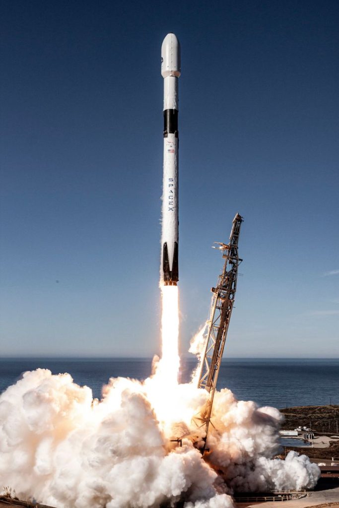
SpaceX has been awarded a $112.7 million contract to launch NOAA’s JPSS-4 satellite. The JPSS-4 is part of the Joint Polar Satellite System (JPSS) program, a cooperative effort between NOAA and NASA. The satellite will be launched atop a Falcon 9 rocket from Vandenberg Space Force Base in 2027. The JPSS program aims to collect critical data on Earth’s land, sea, and air to support weather prediction, climate monitoring, and disaster response. Three JPSS satellites have already been launched and remain operational, contributing to decades of Earth science research. The Falcon 9 has experienced a recent failure, but SpaceX continues to be a key player in space missions. The JPSS fleet will eventually consist of five satellites, with JPSS-3 scheduled to launch in 2032.

Summary

  • SpaceX wins $112.7 million contract for JPSS-4 launch.
  • JPSS-4 is part of NOAA and NASA’s Joint Polar Satellite System.
  • Launch scheduled for 2027 from Vandenberg Space Force Base.
  • JPSS satellites collect vital Earth data for weather, climate, and disaster monitoring.
  • Three operational JPSS satellites: Suomi NPP, JPSS-1, and JPSS-2.
  • Falcon 9 has launched 69 times in 2024 but recently suffered a failure.
  • JPSS-3 scheduled for 2032, completing the five-satellite fleet.
  • SpaceX’s Falcon 9 grounded temporarily due to recent mission failure.
  • JPSS program enhances Earth science research and benefits humanity.

SpaceX to Launch NOAA’s Advanced Climate Satellite with $113 Million Contract

SpaceX, the private spaceflight company founded by Elon Musk, continues to expand its portfolio of significant space missions. In 2027, the company will launch the U.S. National Oceanic and Atmospheric Administration’s (NOAA) JPSS-4 satellite from California’s Vandenberg Space Force Base. This mission, secured with a firm, fixed-price contract worth $112.7 million, marks another milestone in SpaceX’s busy launch schedule.

Overview of the JPSS Program

The Joint Polar Satellite System (JPSS) is a collaborative effort between NOAA and NASA. This constellation of satellites plays a crucial role in collecting comprehensive data on Earth’s land, sea, and air. Such data are pivotal for continuous observation of Earth’s environment, aiding in understanding and predicting changes in weather, climate, oceans, and coasts. This information supports the nation’s economy, protects lives and property, and advances Earth science research.

NASA officials stated, “These data support NOAA’s mission for continuous observation of Earth’s environment to understand and predict changes in weather, climate, oceans, and coasts to support the nation’s economy and protect lives and property. NASA uses the instruments aboard the JPSS satellites to continue decades of Earth science research for the betterment of humanity.

JPSS Satellites: A Legacy of Environmental Monitoring

Three JPSS satellites have been launched to date, and all remain operational, providing invaluable data for environmental monitoring:

  1. Suomi NPP: Launched in October 2011 atop a United Launch Alliance Delta II rocket.
  2. JPSS-1 (NOAA-20): Launched in November 2017 and renamed NOAA-20 upon reaching its final orbit, also via a Delta II rocket.
  3. JPSS-2 (NOAA-21): Launched in November 2022 atop an Atlas V rocket.

These satellites have established a robust legacy of environmental monitoring, and the JPSS fleet will eventually comprise five satellites. The next in line, JPSS-3, is scheduled for launch in 2032.

Importance of the JPSS-4 Mission

The JPSS-4 satellite is expected to further enhance NOAA’s capability to monitor and predict environmental changes. By providing detailed observations of atmospheric, oceanic, and terrestrial conditions, JPSS-4 will contribute to more accurate weather forecasting, climate monitoring, and disaster response efforts. This information is vital for various sectors, including agriculture, aviation, and emergency management.

SpaceX’s Role and the Falcon 9 Rocket

SpaceX’s Falcon 9 rocket will be the launch vehicle for the JPSS-4 mission. Known for its reliability and reusability, the Falcon 9 has become a cornerstone of SpaceX’s operations. In 2024 alone, the Falcon 9 has launched 69 times, showcasing its capability to handle a high volume of missions.

However, the rocket recently experienced a setback. On July 11, 2024, the Falcon 9’s upper stage developed a leak of liquid oxygen during a mission, preventing it from completing an orbit-raising engine burn as planned. As a result, the rocket deployed its payloads—20 Starlink internet satellites—too low, leading to their presumed demise in Earth’s atmosphere. Despite this incident, SpaceX’s track record remains strong, and the company is expected to resolve the issue promptly.

Financial and Technical Aspects

The $112.7 million contract awarded to SpaceX includes not only the launch services but also other mission-related costs. This investment underscores the importance of the JPSS-4 mission and highlights SpaceX’s capability to deliver complex and critical space missions.

The JPSS program builds on decades of Earth science research. The data collected by these satellites help scientists understand long-term climate trends and provide critical information for disaster preparedness and response. With the addition of JPSS-4 and the eventual launch of JPSS-3 in 2032, the JPSS fleet will continue to be a cornerstone of environmental monitoring and research.

Impact on Earth Science and Humanity

The JPSS satellites, including the upcoming JPSS-4, are equipped with advanced instruments that provide detailed observations of various environmental parameters. These observations are crucial for numerous applications:

  • Weather Prediction: Accurate weather forecasts are essential for agriculture, transportation, and emergency management. The data from JPSS satellites help meteorologists make precise predictions, improving public safety and economic stability.
  • Climate Monitoring: Long-term climate data are vital for understanding global warming and its impacts. JPSS satellites contribute to climate models, aiding scientists in predicting future climate scenarios.
  • Disaster Response: Real-time data from JPSS satellites support disaster response efforts by providing critical information on storms, wildfires, floods, and other natural disasters. This information helps authorities make informed decisions, potentially saving lives and reducing property damage.

SpaceX to Launch NOAA’s Advanced Climate Satellite with $113 Million Contract

Technical Specifications of JPSS-4

Parameter Specification
Launch Vehicle Falcon 9
Launch Site Vandenberg Space Force Base
Satellite Operator NOAA
Mission Type Earth Observation
Instrumentation Advanced Environmental Sensors
Primary Objective Weather and Climate Monitoring
Contract Value $112.7 million

SpaceX’s Broader Mission Portfolio

SpaceX is important in the commercial space sector. The company is busy with many launches. These include missions with astronauts and commercial satellite deployments. They also do interplanetary exploration missions. The Falcon 9 rocket has a part called the reusable first stage. This part of the rocket can be used again. This feature has changed space travel by making launches cheaper and more frequent.

Despite the recent setback with the Falcon 9, SpaceX’s innovative approach to spaceflight ensures that such challenges are addressed swiftly. The company’s commitment to continuous improvement and its track record of successful missions position it as a leader in the aerospace industry.

The JPSS program is set to continue its mission of providing critical environmental data well into the future. With JPSS-3 and JPSS-4 scheduled for launch, the program will enhance its observational capabilities, contributing to a better understanding of Earth’s complex environmental systems.

Conclusion

The partnership between SpaceX, NOAA, and NASA shows the teamwork needed for advancing space exploration and Earth science. The launch of the JPSS-4 satellite in 2027 will help NOAA improve its environmental monitoring. It will also strengthen SpaceX’s reputation as a dependable and innovative launch provider. The JPSS program will keep evolving and help tackle environmental challenges.

By using advanced technology and working together, missions like JPSS-4 help us understand our planet better. This understanding will benefit humanity.

Hashtags

#SpaceX, #NOAA, #JPSS4, #ClimateMonitoring, #EarthScience, #WeatherPrediction, #SatelliteLaunch, #Falcon9, #NASA, #EnvironmentalMonitoring

Climate Change Experiments: NASA’s PREFIRE CubeSats Start Groundbreaking Mission

Key Takeaway:

NASA’s PREFIRE mission, comprising two CubeSats launched on Rocket Lab’s Electron rocket, aims to study Earth’s polar regions and improve climate models. The data collected will help predict changes in ice, sea levels, and weather patterns in a warming world.

Summary

  • Mission Overview: PREFIRE’s goal is to understand how Earth’s poles regulate the planet’s energy balance.
  • Launch Details: Two CubeSats launched from Māhia, New Zealand, with the second launch on June 5, 2024.
  • Scientific Objectives: Study far-infrared radiation emissions from the Arctic and Antarctic.
  • Technological Innovation: Use of miniaturized thermal infrared spectrometers.
  • Impact: Improved climate and weather prediction models.
  • Collaboration: Joint effort between NASA, University of Wisconsin-Madison, and Blue Canyon Technologies.

Introduction

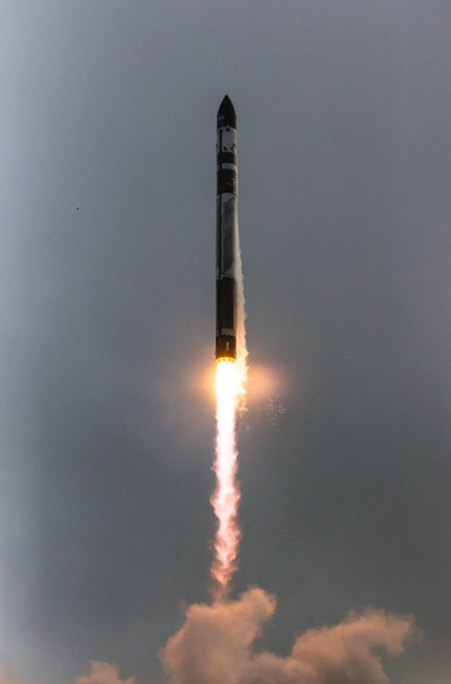
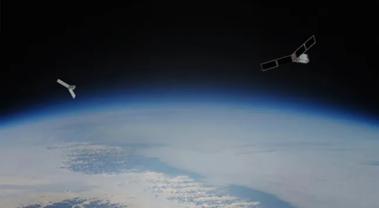
NASA has embarked on a pioneering mission to study the impact of climate change on Earth’s polar regions. This mission, known as PREFIRE (Polar Radiant Energy in the Far-InfraRed Experiment), utilizes two small CubeSats equipped with advanced thermal infrared spectrometers. Launched on Rocket Lab’s Electron rocket from Māhia, New Zealand, these CubeSats aim to provide crucial data to enhance our understanding of climate dynamics and improve predictive models.

PREFIRE Mission Overview

The PREFIRE mission is designed to fill a critical gap in our understanding of how Earth’s poles influence the global climate system. By measuring far-infrared radiation emitted from the Arctic and Antarctic, scientists can gain insights into the energy balance of our planet. This information is vital for predicting changes in ice cover, sea levels, and weather patterns as the climate continues to warm.

Launch Details and Mission Timeline

The PREFIRE mission consists of two CubeSats, each about the size of a shoebox. The first CubeSat was launched on May 25, 2024, followed by the second on June 5, 2024. Both launches took place from Rocket Lab’s Launch Complex 1 in Māhia, New Zealand. Following a 30-day checkout period, during which engineers and scientists will verify the CubeSats’ functionality, the mission is expected to operate for ten months.

Table 1: Launch Details

Event Date Location
First CubeSat Launch May 25, 2024 Māhia, New Zealand
Second CubeSat Launch June 5, 2024 Māhia, New Zealand
Mission Duration 10 months Near-polar orbits

Scientific Objectives

The primary scientific objective of the PREFIRE mission is to measure far-infrared radiation from Earth’s polar regions. The poles act as radiators, shedding much of the heat absorbed at the tropics back into space. Understanding this process is crucial for modeling the Earth’s energy budget and predicting climate change impacts.

Technological Innovation

Each PREFIRE CubeSat carries a thermal infrared spectrometer, an instrument designed to measure infrared wavelengths. The spectrometers use specially shaped mirrors and sensors, miniaturized to fit within the compact CubeSat frame. These advanced sensors are more sensitive than previous instruments, allowing for more precise measurements.

Impact on Climate and Weather Models

The data collected by the PREFIRE mission will enhance our understanding of how polar regions contribute to Earth’s overall energy balance. This information will improve the accuracy of climate and weather prediction models, leading to better forecasts and more informed decision-making.

Table 2: Expected Impacts of PREFIRE Data

Area of Impact Description
Sea Level Rise Improved predictions of melting ice and rising seas
Weather Patterns Better understanding of polar influence on weather
Snow and Ice Cover Accurate tracking of changes in polar ice sheets
Climate Models Enhanced models for long-term climate predictions

The PREFIRE mission is a collaborative effort involving several key partners. NASA’s Jet Propulsion Laboratory (JPL) manages the mission, with the University of Wisconsin-Madison responsible for data processing. Blue Canyon Technologies built the CubeSats, while Rocket Lab USA Inc. provided the launch services. The mission is part of NASA’s Venture-class Acquisition of Dedicated and Rideshare (VADR) launch services contract.

The PREFIRE mission represents a significant step forward in climate research. By providing detailed measurements of far-infrared radiation from Earth’s polar regions, it will contribute to a more comprehensive understanding of the climate system. This knowledge is essential for developing effective strategies to reduce and adapt to the impacts of climate change.

NASA’s PREFIRE mission is a groundbreaking effort to study the far-infrared radiation emitted from Earth’s polar regions. The data collected by the two CubeSats will enhance our understanding of the planet’s energy balance and improve climate and weather prediction models. This mission exemplifies the power of collaboration and technological innovation in advancing our knowledge of climate change and its impacts on Earth.

For additional information about PREFIRE, please visit:

https://science.nasa.gov/mission/prefire/

Hashtags:

#NASA, #PREFIRE, #ClimateChange, #CubeSats, #PolarResearch, #EarthScience, #InfraredRadiation, #ClimateModels, #EnvironmentalScience


NASA Launches Cutting-Edge Satellite for Polar Climate Study

Key Takeaway

NASA launched the first of two shoebox-sized satellites called PREFIRE (Polar Radiant Energy in the Far-InfraRed Experiment) to study Earth’s heat emissions at the poles. This data will improve our understanding of how Earth’s climate is changing.

Summary

  • Mission Goal: The PREFIRE mission aims to measure the amount of heat Earth radiates from the poles, which are critical regions for regulating Earth’s climate.
  • Launch: The first PREFIRE CubeSat was launched on May 25, 2024, aboard an Electron rocket from Rocket Lab. A second launch is planned soon.
  • Mission Duration: The mission is expected to operate for 10 months after a 30-day checkout period.
  • Scientific Importance: The far-infrared radiation emitted from Earth’s poles is not currently well-measured. PREFIRE will provide crucial data to improve our understanding of Earth’s energy balance and how it is affected by factors like ice melt and cloud cover.
  • Benefits: Improved climate and weather models will aid researchers in predicting the impacts of climate change on Earth’s ice, seas, and weather patterns. This information will be valuable for sectors like agriculture, fishing, and coastal communities.
  • Partners: This collaborative mission was developed by NASA and the University of Wisconsin-Madison.
  • Tech Behind the Mission: The tiny satellites, called CubeSats, carry miniaturized thermal infrared spectrometers to measure infrared wavelengths.

NASA Launches Cutting-Edge Satellite for Polar Climate Study

Our planet’s climate is a complicated dance between incoming solar radiation and the heat Earth radiates back out into space. Understanding this energy balance is crucial for predicting the impacts of climate change. But there’s a critical gap in our knowledge: far-infrared radiation emitted from Earth’s poles, which play a giant role in regulating global temperatures, remains poorly measured.

This is where NASA’s recently launched PREFIRE (Polar Radiant Energy in the Far-InfraRed Experiment) mission comes in.

Shedding Light on the Polar Chill

PREFIRE is a game-changer. Forget clunky, massive satellites – the mission utilizes two minisatellites, affectionately called CubeSats, each about the size of a shoebox. These tiny titans pack a powerful punch, carrying miniaturized thermal infrared spectrometers to measure the far-infrared wavelengths escaping from Earth’s poles.

The first PREFIRE CubeSat hitched a ride on a Rocket Lab’s Electron rocket on May 25, 2024, with its twin set to follow soon. Following a checkout period, the mission is expected to be operational for 10 months, gathering crucial data on Earth’s energy balance at the Arctic and Antarctic.

Big Benefits from Small Packages

The significance of PREFIRE cannot be overstated. By filling this critical data gap, the mission will provide scientists with a more comprehensive picture of Earth’s energy budget. This improved understanding will significantly enhance climate and weather models, allowing for more accurate predictions of how a warming world will affect Earth’s polar ice caps, sea levels, and weather patterns.

These insights have far-reaching implications. Better climate models will equip sectors like agriculture, fishing, and coastal communities with the knowledge they need to prepare for and adapt to the inevitable consequences of climate change.

A Collaborative Effort with Monumental Potential

The PREFIRE mission is a testament to the power of collaboration. This innovative project is a joint effort between NASA and the University of Wisconsin-Madison. While NASA’s Jet Propulsion Laboratory manages the mission and provided the spectrometers, Blue Canyon Technologies built the CubeSats, and the University of Wisconsin-Madison will take the lead in processing the treasure trove of data collected during the mission.

The miniaturization of the technology behind PREFIRE represents another major leap forward in space exploration. These CubeSats demonstrate the immense potential of smaller, more cost-effective satellites to revolutionize our understanding of Earth and beyond.

The launch of the first PREFIRE CubeSat marks a new chapter in Earth science. With these tiny titans gazing down at our planet’s poles, we can anticipate giant strides in unraveling the mysteries of Earth’s climate and charting a course for a sustainable future.

For more details, read the source: NASA’s PREFIRE Mission.

HASHTAGS:

#NASA, #ClimateChange, #EarthScience, #PREFIRE, #CubeSats, #RemoteSensing, #Poles, #FarInfrared, #EnergyBalance, #ClimatePrediction #arctic ice climate change

Antarctic 2024: Another Giant Antarctic Iceberg Breaks Free

Key Takeaway

The recent calving of a giant iceberg (A-83) from the Brunt Ice Shelf in Antarctica is another sign of the weakening ice shelves due to rising global temperatures.

Summary

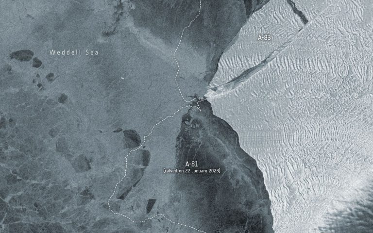
  • A large iceberg measuring 380 square kilometers (147 square miles) named A-83 broke away from the Brunt Ice Shelf in Antarctica on May 20th, 2024.
  • This is the third major calving event in Antarctica in the last four years, following A-74 in 2021 and A-81 in 2023.
  • Satellites like ESA’s Copernicus Sentinel-1 and NASA’s Landsat 8 captured the calving event using radar imaging and thermal data.
  • The calving is attributed to the weakening of ice caused by the McDonald Ice Rumples and the extension of the ‘Halloween Crack’ in the Brunt Ice Shelf.
  • Scientists use satellite data to monitor ice shelf health in response to climate change.
  • The iceberg doesn’t pose a threat to the Halley VI Research Station, which was relocated earlier due to ice shelf instability.
  • The ongoing ice loss in Antarctica is a worrying sign of global warming, leading to sea-level rise, coastal flooding, and further temperature increase.
  • Monitoring polar ice plays a crucial role in climate change adaptation and reduction strategies.
Data on brightness temperature is from the U.S. Landsat 8 mission. Credit: ESA/USGS

Another Antarctic Iceberg Breaks Away

The icy expanse of Antarctica is constantly changing, but a recent event has scientists raising a collective eyebrow. On May 20th, 2024, a massive iceberg measuring a staggering 380 square kilometers (147 square miles) broke away from the Brunt Ice Shelf. This behemoth, named A-83, marks the third significant calving event in Antarctica in just four years, following A-74 in 2021 and the even larger A-81 in 2023.

These repeated calving events are a stark reminder of the accelerating impact of climate change on the Earth’s polar regions. The Brunt Ice Shelf is a critical buttress for glaciers flowing into the Weddell Sea. As the ice shelf weakens, these glaciers lose support and accelerate their flow into the ocean, contributing to rising sea levels.

The culprit behind the recent calving is a combination of factors. The McDonald Ice Rumples, underwater ridges that disrupt the flow of ice, have weakened the Brunt Ice Shelf for some time. Additionally, a vast crack, ominously nicknamed the “Halloween Crack,” has steadily grown within the ice shelf, further compromising its structural integrity.

Thankfully, sophisticated Earth observation satellites are keeping a watchful eye on Antarctica. ESA’s Copernicus Sentinel-1 and NASA’s Landsat 8 played a vital role in capturing the calving event. Sentinel-1, with its radar imaging capabilities, can see through clouds and darkness, providing valuable data year-round. Landsat 8, on the other hand, uses thermal imaging to help scientists assess ice sheet thickness. By analyzing these different datasets, scientists can monitor changes in ice shelves and understand the mechanisms driving calving events.

The good news is that the A-83 iceberg doesn’t pose an immediate threat to the British Antarctic Survey’s Halley VI Research Station. The station was strategically relocated in 2017 due to concerns about ice shelf stability. However, the bigger picture remains a cause for concern. The ongoing loss of ice from Antarctica is a significant contributor to rising sea levels. This, in turn, threatens coastal communities around the world with increased flooding and erosion.

Furthermore, as polar ice sheets melt, they expose darker ocean surfaces that absorb more solar radiation. This creates a vicious cycle, accelerating global warming even further.

The recent calving event in Antarctica underscores the urgency of addressing climate change. Continued monitoring of the polar ice caps through advanced satellite technology is crucial for understanding the pace and impact of ice loss. This data is essential for developing effective mitigation strategies and adaptation plans to tackle the challenges posed by a warming planet.

This isn’t just a story about a giant iceberg breaking free. It’s a story about the interconnectedness of our planet and the far-reaching consequences of climate change. By understanding the science behind these events, we can take informed action to ensure a sustainable future for ourselves and generations to come.

HASHTAGS:

#Antarctica, #Icebergs, #ClimateChange, #GlobalWarming, #Glaciology, #EarthScience, #SeaLevelRise, #RemoteSensing, #PolarIce, #Environment, #antarctic 2024

References

  1. IPCC Sixth Assessment Report – Intergovernmental Panel on Climate Change (IPCC)
  2. Iceberg A-83 Breaks Free – European Space Agency (ESA)

PREFIRE Mission by NASA Set to Explore Earth’s Poles

Key Takeaway

NASA’s PREFIRE mission is set to enhance our understanding of heat emissions from Earth’s poles using a pair of cubesats designed to measure far-infrared radiation. This data will provide critical insights into the rapidly changing polar climates and their global impacts.

Summary

  • Mission Name: Polar Radiant Energy in the Far-Infrared Experiment (PREFIRE)
  • Objective: Measure heat emissions from Earth’s polar regions
  • Satellites: Two cubesats, “Ready, Aim, PREFIRE” and “PREFIRE and ICE”
  • Launch Dates: May 22 (Ready, Aim, PREFIRE), a few days later (PREFIRE and ICE)
  • Launch Site: Rocket Lab’s Launch Complex 1, Māhia, New Zealand
  • Primary Instrument: Thermal infrared spectrometers
  • Key Measurements: Far-infrared radiation (wavelengths > 15 microns)
  • Significance: Data to improve climate models, predict sea level rise, and understand polar climate impacts
  • Accessibility: Open and freely available data for global scientists
  • Partners: University of Wisconsin-Madison, NASA’s Jet Propulsion Laboratory
  • Similar Missions: Mars Climate Sounder (MCS), Diviner Lunar Radiometer Experiment

The PREFIRE Mission

Heat emissions from Earth’s polar regions are a critical component of our planet’s climate system. However, we know surprisingly little about how this heat is lost to space. NASA’s Polar Radiant Energy in the Far-Infrared Experiment (PREFIRE) aims to change that. This mission, involving two small cubesats, will provide unprecedented data on the far-infrared radiation emitted from the Arctic and Antarctic, offering new insights into the polar climate and its broader impacts on global weather systems.

Mission Overview

The Satellites

PREFIRE consists of two cubesats, rightly named “Ready, Aim, PREFIRE” and “PREFIRE and ICE.” These compact satellites, each about the size of a loaf of bread, will launch separately into near-polar orbits. The first cubesat is scheduled to launch on May 22, 2024, aboard a Rocket Lab Electron rocket from Māhia, New Zealand. The second will follow a few days later.

Scientific Goals

The primary goal of PREFIRE is to measure far-infrared radiation, specifically wavelengths longer than 15 microns. This spectrum accounts for approximately 60% of the total heat lost at the poles. “We’ve never measured that before,” said Tristan L’Ecuyer, PREFIRE’s Principal Investigator at the University of Wisconsin-Madison, emphasizing the mission’s groundbreaking nature.

The Importance of Polar Heat Emissions

Rapid Arctic Warming

The Arctic is experiencing warming at a rate faster than any other region on Earth, leading to significant changes in local ecosystems and global weather patterns. Understanding how heat is emitted from this region is crucial for predicting future climate changes. “Ultimately, [PREFIRE] information is going to be combined with our climate models,” L’Ecuyer explained, “and hopefully we’ll be able to improve our ability to simulate what sea level rise might look like in the future.”

Global Climate Impacts

The data collected by PREFIRE will be invaluable in refining our climate models, particularly in understanding how polar changes affect weather systems worldwide. This includes better predictions of phenomena such as sea level rise and extreme weather events.

Technical Specifications

Instruments and Design

Each PREFIRE cubesat is equipped with a single thermal infrared spectrometer. These instruments are scaled-down versions of technology used in previous NASA missions, such as the Moon Mineralogy Mapper (M3) and the Mars Climate Sounder (MCS). Mary White, PREFIRE Project Manager at NASA’s Jet Propulsion Laboratory, noted, “We’ve adapted proven technology for a cost-effective, focused mission.”

Dual-Satellite Approach

Having two satellites provides a unique advantage. “Having one cubesat would be able to sort of map out what the emission looks like in the polar regions,” said L’Ecuyer. “We’ll be using the two cubesats to make measurements over the course of several hours, taking the difference between those measurements and trying to understand how the processes that are occurring in the Arctic are actually affecting the emission from the Arctic.”

Broader Context and Collaboration

Part of a Larger Effort

PREFIRE fits into NASA’s broader strategy of combining large-scale missions with smaller, specialized ones to create a comprehensive understanding of Earth’s climate system. Karen St. Germain, NASA’s Earth Science Division director, explained, “NASA needs both our large missions and these smaller missions… to answer this full range of questions we have about understanding the Earth as a system.”

Data Accessibility

In line with NASA’s commitment to open science, all data collected by PREFIRE will be freely available to the public. This ensures that researchers worldwide can access and utilize this valuable information to further our collective understanding of climate dynamics. “All NASA data are open and freely available to all scientists or all people who are interested around the world,” White confirmed.

Expected Outcomes

Enhanced Climate Models

The insights gained from PREFIRE will significantly enhance our climate models. By providing detailed measurements of far-infrared radiation, scientists can better understand the heat exchange processes at the poles and their influence on global climate systems. This will improve predictions of future climate scenarios, including the rate and impact of sea level rise.

Informed Policy Decisions

The data from PREFIRE will not only advance scientific knowledge but also inform policy decisions related to climate change mitigation and adaptation. Accurate climate models are essential for developing effective strategies to address the ongoing and future impacts of global warming.

Tables

Table 1: Key Details of PREFIRE Mission

Component Details
Mission Name Polar Radiant Energy in the Far-Infrared Experiment (PREFIRE)
Objective Measure heat emissions from Earth’s polar regions
Satellites Two cubesats: “Ready, Aim, PREFIRE” and “PREFIRE and ICE”
Launch Dates May 22, 2024 (Ready, Aim, PREFIRE), a few days later (PREFIRE and ICE)
Launch Site Rocket Lab’s Launch Complex 1, Māhia, New Zealand
Primary Instrument Thermal infrared spectrometers
Measurement Focus Far-infrared radiation (wavelengths > 15 microns)
Data Accessibility Open and freely available to the public
Partners University of Wisconsin-Madison, NASA’s Jet Propulsion Laboratory

Table 2: Similar NASA Missions and Technologies

Mission Objective Key Instrument Outcome
Mars Climate Sounder (MCS) Study Martian atmosphere and climate Thermal infrared spectrometer Improved understanding of Martian climate processes
Diviner Lunar Radiometer Experiment Measure lunar surface temperatures Radiometer Detailed thermal maps of the Moon’s surface
Moon Mineralogy Mapper (M3) Map mineral composition of the Moon Imaging spectrometer Discovery of water/hydroxyl on the lunar surface

NASA’s PREFIRE mission represents a significant step forward in our understanding of the polar climate and its global impacts. By measuring far-infrared radiation from the Arctic and Antarctic, PREFIRE will provide critical data to improve climate models, predict sea level rise, and understand the broader effects of polar climate change. The mission’s open data policy ensures that scientists worldwide can access and utilize this information, fostering global collaboration in the fight against climate change.

With PREFIRE, NASA continues to lead the way in climate research, combining cutting-edge technology with a commitment to open science and international cooperation. As the mission unfolds, the data collected will be invaluable in our efforts to understand and mitigate the impacts of a warming world.

Hashtags

#NASA, #PREFIRE, #ClimateChange, #EarthScience, #PolarResearch, #FarInfrared, #Cubesats, #ArcticWarming, #GlobalWarming, #ClimateModels, #SpaceResearch, #NASAClimate, #OpenScience
Pin It
error: Content is protected !!

This website utilizes first- and third-party tools that store small files (cookies) on your device. These cookies serve various purposes, including ensuring the site functions correctly (technical cookies), analyzing site usage (analytics cookies), and delivering relevant advertisements (profiling cookies). While technical cookies are essential and used by default, you have the option to enable or disable analytics and profiling cookies. By allowing these cookies, you help us enhance your browsing experience.