Tag

#EarthObservation

Browsing

QuantX Labs’ TEMPO Mission: First Optical Frequency Comb Launch to Orbit in 2025

QuantX Labs is set to deploy its TEMPO optical atomic clock subsystem—an Optical Frequency Comb—into low Earth orbit late in 2025, backed by a $3.7 million grant from the Australian Space Agency’s Moon to Mars initiative. This first-ever spaceborne frequency comb will undergo rigorous environmental testing on Exotrail’s spacevan™, flown by SpaceX, paving the way for ultra‑precise space-based timing, navigation, and Earth observation systems that could one day rival GPS.

Summary

  • QuantX Labs, a leader in quantum sensor technologies, will launch a key component of its TEMPO atomic clock system into space aboard Exotrail’s spacevan™ on a SpaceX mission.
  • The project is supported by a $3.7 million grant from the Australian space Agency’s Moon to Mars initiative, demonstrating strong government backing for sovereign space capabilities.
  • The subsystem, known as an Optical Frequency Comb, extends beyond timing to deep‑space communications, navigation, positioning, and synchronized Earth observation.
  • This mission marks the first deployment of an optical frequency comb in orbit—an innovation that earned the Nobel Prize in Physics in 2005—but never before flown.
  • The comb has passed extensive environmental tests (temperature extremes, vacuum, vibration, radiation) to endure launch stresses and space conditions.
  • Exotrail’s spacevan™ made its debut flight on SpaceX Transporter‑9 in November 2023, proving its in‑orbit mobility service capability.
  • QuantX Labs’ Managing Director, Professor Andre Luiten, calls this launch a “breakthrough” achieved faster and at lower cost than traditional atomic clock missions.
  • Dr. Sebastian Ng, QuantX’s PNT Program Lead, notes that the comb’s success will guide integration of the full TEMPO clock for future missions.
  • A QuantX team will travel to Exotrail’s Paris HQ this month for final integration tests before shipment to the U.S. launch site.
  • The one‑year mission will be Exotrail’s second spacevan™ flight following the successful 2023 demo; ongoing operations bolster confidence in the service.
QuantX Labs’ TEMPO Mission First Optical Frequency Comb Launch to Orbit in 2025

Introduction

QuantX Labs, based in Adelaide, Australia, is at the forefront of precision timing and quantum sensing. In partnership with French in‑space logistics firm Exotrail, QuantX is preparing to launch the Optical Frequency Comb—a core part of its TEMPO optical atomic clock—into low Earth orbit late in 2025 aboard Exotrail’s spacevan™ on a SpaceX Falcon 9 rideshare QuantX Labs – Quantifying The Unknown. The project is underwritten by a $3.7 million grant from the Australian Space Agency’s Moon to Mars initiative, reflecting Australia’s commitment to sovereign space‑based navigation and timing.

Background on Optical Frequency Combs

Optical Frequency Combs were first pioneered around 2000 and garnered the Nobel Prize in Physics in 2005 for their role in precision spectroscopy and timing QuantX Labs – Quantifying The Unknown. These “combs” produce a spectrum of discrete, equally spaced optical frequencies that serve as an ultra‑stable ruler for measuring time and frequency. On the ground, combs have revolutionized telecommunications and metrology. Flying one in space opens new frontiers in deep‑space communications, navigation, and synchronized Earth observation.

“This launch represents not only a breakthrough for our TEMPO technology but also the culmination of countless hours of hard work by our engineers and physicists. We have managed to deliver this outcome in much less time and at much less cost than is traditional,” said Professor Andre Luiten, Managing Director of QuantX Labs QuantX Labs – Quantifying The Unknown.

TEMPO Atomic Clock System

The TEMPO (Time‑based Precision Oscillator) system integrates the Optical Frequency Comb with cutting‑edge lasers, atomic references, and control electronics. Together, they form an optical atomic clock capable of 10⁻¹⁸ timing precision—orders of magnitude better than current space clocks Orbital Today. TEMPO’s modular design allows the comb to serve as a subsystem ahead of the full payload, reducing risk and enabling iterative technology maturation.

Environmental Testing and Validation

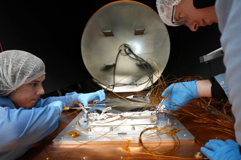
QuantX’s Optical Frequency Comb has successfully endured a battery of harsh environmental tests designed to simulate launch and on‑orbit conditions:

Test Type Simulated Condition Status
Temperature Extremes –40 °C to +85 °C cycling Passed
High Vacuum 10⁻⁶ Torr level Passed
Vibration & Shock Random and sine vibration profiles Passed
Radiation Exposure Total ionizing dose > 10 kRad(Si) Passed

Table 1: Environmental Test Results for Temporal Stability

Mission Timeline and Partnerships

Milestone Date Partner/Location
Grant Awarded April 2025 Australian Space Agency
Integration Testing Begins April 2025 Exotrail HQ, Paris, France
Shipment to Launch Site Late 2025 U.S. West Coast
Orbital Launch December 2025 (TBD) SpaceX Falcon 9
Mission Operations Period 1 year LEO

Table 2: Key Mission Timeline for the Optical Frequency Comb Launch QuantX Labs – Quantifying The Unknown

Exotrail’s spacevan™ made its maiden flight on SpaceX’s Transporter‑9 mission in November 2023, demonstrating its in‑orbit transfer capabilities before handling the QuantX payload exotrail.com. This upcoming flight will be the spacevan’s second orbital mission, leveraging that flight heritage to ensure mission success

Future Applications and Impact

Beyond demonstrating an Australian sovereign timing capability, this mission lays groundwork for next‑generation navigation, deep‑space networks, and Earth observation. By flying optical clocks in space, QuantX aims to supplement or even replace existing GPS and GNSS systems, offering enhanced accuracy and resilience against signal interference Orbital Today. Dr. Sebastian Ng, QuantX’s PNT Program Lead, notes that insights from the frequency comb deployment will inform the development of the full TEMPO payload on subsequent missions.

Facts

  • Optical Frequency Combs earned the Nobel Prize in Physics in 2005.
  • Exotrail’s spacevan™ offers up to 1 km/s delta‑V for in‑orbit maneuvers exotrail.com.
  • TEMPO aims for timing stability of 10⁻¹⁸, meaning an error of 1 second over 31 billion years Orbital Today.

References

  • QuantX Labs to Launch Pioneering Optical Atomic Clock Technology into Space. QuantX Labs. Link QuantX Labs – Quantifying The Unknown
  • QuantX Labs Prepares First Orbital Launch of Optical Frequency Comb for Space-Based Precision Timing. The Quantum Insider. Link The Quantum Insider
  • Exotrail to debut its SpaceVan™ in‑space mobility service on October 2023 SpaceX Falcon 9 mission. Exotrail. Link exotrail.com
  • In‑Orbit Services – Exotrail. Exotrail. Link exotrail.com
  • Australia’s QuantX Built A Clock So Precise It Could Replace GPS and It’s Heading to Orbit. Orbital Today. Link Orbital Today
  • Exotrail Completes First In‑Orbit Delivery with Spacevan Orbital Transfer Vehicle. Satellite Today. Link Satellite Today

India’s Satellite Constellation Plan Attracts 30 Companies: A New Era of Space Ambitions

India’s move to establish indigenous Earth observation (EO) satellite constellations represents a monumental shift towards self-reliance in space data, reducing dependence on foreign sources while enabling national security and infrastructure advancements.

Summary

  • The Indian National Space Promotion and Authorisation Centre (IN-SPACe) has received nine consortium applications involving 30 companies for India’s satellite constellation project.
  • Objective: Strengthen India’s data sovereignty and reduce reliance on foreign EO satellite data for defense, climate monitoring, and infrastructure development.
  • Market projections estimate the small satellite and data services industry to reach $45 billion globally by 2030.
  • Prominent applicants include Pixxel, a Google-backed startup, and SatSure, supported by Baring Private Equity. Established corporations like Tata Advanced Systems are also involved.
  • Criteria for qualification include raising a minimum investment of Rs 850 million ($10 million) and establishing spacecraft control centers in India.
  • The Indian government offers loans up to Rs 3.5 billion ($42 million) to the selected consortium.
  • Technical evaluations of the applications will conclude by January 2025, leading to a tender process for final selection.
  • This initiative is part of India’s broader space strategy, which also includes a Rs 10 billion venture fund for startups.
  • Success in this endeavor could transform India’s space sector, fostering innovation, economic growth, and data independence.
India's Satellite Constellation Plan Attracts 30 Companies A New Era of Space Ambitions
The people evaluating the applications plan to finish by the end of January 2025. They will complete technical evaluations. This means they will closely examine the technical details of the applications.

India’s Vision: A Bold Leap in Space Exploration

India has steadily emerged as a formidable player in space technology, and this recent initiative underscores the nation’s aspirations to lead the space economy. The Earth Observation (EO) satellite constellations are poised to address critical national needs, from defense to infrastructure planning, while propelling India into the global commercial space arena.

The Indian government’s call for private sector collaboration follows the recent liberalization of the space sector, which opened doors for commercial participation. This marks a significant departure from a previously state-centric model dominated by the Indian Space Research Organisation (ISRO).

“India’s space ecosystem is set to bloom, blending public and private innovation,” said Pawan Goenka, chairman of IN-SPACe.

Market Potential: A Thriving Industry Awaits

The market for small satellites and EO data services is projected to reach $45 billion by 2030. This growth is fueled by the increasing need for high-resolution imagery and real-time analytics in various domains:

Sector Use of EO Data
Defense and Security Surveillance, border monitoring
Infrastructure and Urban Planning Smart city planning, disaster management
Telecommunications Network optimization
Agriculture Crop monitoring, yield forecasting
Climate and Environment Weather prediction, climate change tracking

Private Players: Driving Innovation

The initiative has drawn in many different participants. These participants include startups, which are newly established businesses. Established corporations, which are large companies with a long history, are also joining.

Company Key Strength
Pixxel Expertise in hyperspectral imaging technology
SatSure Specializes in data analytics for agriculture
Tata Advanced Systems Proven track record in defense technology

Government’s Role: Empowering the Ecosystem

Recognizing the high costs associated with satellite projects, the Indian government has taken steps to mitigate financial barriers for private companies. Key measures include:

  • Loans up to Rs 3.5 billion ($42 million) for selected bidders.
  • A Rs 10 billion venture fund to encourage space startups.
  • Support for the establishment of spacecraft control centers within India.

These initiatives aim to ensure that private players have the necessary infrastructure and financial backing to succeed.

Why EO Data Matters

Earth Observation (EO) data serves as the backbone for numerous critical applications:

  • Defense: Monitoring troop movements and securing borders.
  • Disaster Management: Predicting natural disasters and enabling swift response.
  • Agriculture: Assessing crop health and planning irrigation.
  • Urban Development: Supporting smart city initiatives and sustainable planning.

India’s current dependence on foreign EO data, particularly from organizations like the European Space Agency, underscores the urgency of developing indigenous capabilities.

Challenges Ahead

Despite the optimism surrounding the initiative, several challenges must be addressed:

  • Regulatory Hurdles: Ensuring a streamlined process for approvals and compliance.
  • Funding Gaps: Bridging the gap between government loans and total project costs.
  • Technological Complexity: Developing cutting-edge satellites to compete globally.
  • Global Competition: Staying ahead in an increasingly crowded space market.

The Road to 2030

As India aims to complete technical evaluations by January 2025, the timeline for the satellite constellation project is ambitious but achievable. Once implemented, the constellation will transform not only India’s space sector but also its broader economy.

Facts About India’s Space Ambitions

  • India launched its first satellite, Aryabhata, in 1975.
  • The Mars Orbiter Mission (MOM) was completed on a shoestring budget of just $74 million, making it one of the most cost-effective missions ever.
  • India’s Chandrayaan-3 became the first mission to successfully land near the Moon’s south pole.

References

  1. SatSure
  2. Tata Advanced Systems
#IndiaSpaceMission, #EarthObservation, #SatelliteConstellation, #INSPACe, #ISRO, #SpaceStartups, #Pixxel, #SatSure, #TataAdvancedSystems, #SpaceEconomy, #IndiaEOData, #MarsOrbiterMission, #SatelliteTechnology, #SpaceInnovation, #ClimateMonitoring

Sentinel-1C Satellite Successfully Launches Into Space: Advancing Earth Observation

The successful launch of Sentinel-1C on a VEGA-C rocket marks a significant advancement in Earth observation, enhancing our capacity to monitor climate change, respond to natural disasters, and manage land and sea resources. This satellite, part of the European Copernicus program, ensures continuous, high-quality data collection using cutting-edge radar technology, strengthening global environmental monitoring strategies.

Summary

  • Sentinel-1C launched successfully on a VEGA-C rocket and will orbit 700 km above the Earth.
  • Part of the European Copernicus programme, it employs advanced radar technology for all-weather, day-and-night imaging of Earth’s surface.
  • The satellite complements Sentinel-1A, forming a synchronized constellation for enhanced Earth observation capabilities.
  • Sentinel-1C supports critical applications like sea-ice monitoring, forest management, disaster response, and climate tracking.
  • The UK had a crucial role in creating essential parts. These parts included radar subsystems and batteries. Radar subsystems are parts of a system that helps detect objects using radio waves. Batteries are devices that store and provide electrical energy to power various equipment.
  • Airbus Defence and Space UK led the design and manufacture of radar electronic subsystems.
  • Sentinel-1C carries an Automatic Identification System (AIS) for ship collision avoidance and maritime surveillance.
  • This satellite bolsters long-term data collection for operational services rather than research purposes, ensuring reliable information for monitoring environmental changes.
  • Sentinel-1C data is crucial for governments, industries, and academics, offering actionable insights across diverse applications.
  • Copernicus satellites, including Sentinel-2C launched earlier, enable Europe and the UK to maintain leadership in global environmental monitoring.

Mission Overview and Launch Details

Sentinel-1C launched on the VEGA-C rocket. The launch took place at Europe’s Spaceport in French Guiana. Sentinel-1C reached an orbit 700 km above Earth. Its mission is to continue the Sentinel-1 mission. This mission started with Sentinel-1A, which launched in 2014. Both satellites will work together. They will provide continuous and complete Earth observation data.

The satellite is equipped with a Synthetic Aperture Radar (SAR), a highly advanced technology capable of capturing images of the Earth’s surface regardless of weather conditions or time of day. SAR’s versatility makes it invaluable for monitoring Arctic ice, detecting land movements, and assessing disaster impacts.

For further details about the Sentinel-1 mission, visit Sentinel Copernicus.

Role of the UK in Sentinel-1C Development

The UK played an important role in developing Sentinel-1C. Airbus Defence and Space in Portsmouth provided the electronics subsystem for the SAR instrument, while Enersys ABSL in Abingdon supplied the satellite’s battery.

Justin Byrne, Head of Earth Observation at Airbus UK, emphasized, “The UK has designed and manufactured radar electronics for the entire Sentinel-1 family, ensuring critical European satellite missions remain operational.”

The satellite exemplifies the UK’s commitment to Earth observation and innovation, supported by funding from the UK Space Agency. The nation’s contributions bolster the global impact of the Copernicus program and enhance its ability to deliver consistent, actionable data.

Sentinel-1C Satellite Successfully Launches Into Space Advancing Earth Observation

Applications and Benefits of Sentinel-1C

Sentinel-1C’s high-resolution radar data serves a broad range of applications, including:

Application Impact
Climate Change Monitoring Tracks sea ice extent, glacier motion, and other climate variables to assess global warming.
Disaster Response Provides real-time data for responding to floods, earthquakes, and volcanic eruptions.
Maritime Surveillance Tracks shipping routes, detects piracy, and enhances global maritime safety.
Agriculture and Forestry Monitors soil health, forest cover, and water resources to support sustainable practices.

The satellite’s Automatic Identification System (AIS) adds a new dimension to maritime safety by tracking vessels and detecting illegal activities like unregulated fishing and piracy. Learn more about Earth observation benefits at Innovation News Network.

Long-Term Data Collection for Climate Change

Unlike research satellites, Sentinel-1C is designed for operational service, ensuring consistent and reliable data for decades. Its capabilities are critical for addressing some of the world’s most pressing issues:

  • Land Motion Monitoring: Detects subtle ground movements in urban areas, enabling preventive measures against infrastructure failures.
  • Sea Ice and Oceanography: Tracks changes in Arctic and Antarctic ice, crucial for understanding the impacts of global warming.
  • Disaster Preparedness: Improves early warning systems for earthquakes and floods, saving lives and minimizing economic losses.

Dr. Chandra Taposeea-Fisher, Chair of the EO Committee at UKspace, explained, “Sentinel-1C’s data will empower communities and governments to make informed decisions about environmental conservation and disaster reduction.”

Technological Innovations

The SAR technology aboard Sentinel-1C is complemented by the newly integrated Automatic Identification System (AIS). This combination enables comprehensive monitoring of global maritime activities, from enhancing shipping efficiency to detecting environmental hazards like oil spills.

Professor Remedios emphasized the significance of operational radar satellites:
“The advent of radar satellites has revolutionized our ability to observe hazardous and extreme environments.”

This innovation aligns with the Copernicus programme’s mission to provide free, accessible data to scientists, governments, and industries worldwide.

Facts

  • Sentinel-1C can capture radar images through clouds and at night, unlike optical satellites.
  • The radar operates at C-band frequencies, enabling detailed surface mapping.
  • The satellite’s data archive will contribute to machine learning algorithms, further enhancing Earth observation research.

References

  1. How Earth Observation Satellite Data Is Used to Benefit Society
  2. Sentinel Copernicus: Sentinel-1
#Sentinel1C, #CopernicusProgramme, #EarthObservation, #ClimateChange, #MaritimeSafety, #SatelliteTechnology, #SARImaging, #GlobalMonitoring, #DisasterResponse, #UKSpaceIndustry, #Innovation, #EarthScience, #SpaceExploration, #RadarTechnology, #ClimateTracking

The Final Vega Rocket Launch: A Look at the End of an Era in Space Travel

The final Vega rocket launch marks the end of a significant chapter in space travel. After 12 years and 20 successful missions, Vega is retiring to make way for the more advanced Vega-C rocket. This article explores Vega’s legacy, its missions, and what the future holds for European space exploration.

Summary

  • Vega’s Final Launch: The last Vega rocket launched on September 5, 2024, carrying the Sentinel-2C satellite.
  • Vega’s History: Launched its maiden flight in February 2012 and has completed 20 successful missions.
  • Key Missions: Included LISA Pathfinder (2015), Proba-V (2013), and Aeolus (2018), among others.
  • Payload Capability: Vega specialized in launching smaller satellites into polar orbit.
  • Transition to Vega-C: The new Vega-C rocket will handle future missions, offering improved performance and capacity.
  • Rocket Specifications: Vega was 30 meters tall, with three solid-propellant stages and one liquid-propellant stage.
  • Future of Space Travel: Vega-C is set to continue the legacy with enhanced capabilities and new technologies.

The Final Vega Rocket Launch

On September 5, 2024, the European Space Agency (ESA) bid farewell to its Vega rocket, concluding an era of reliable and efficient space missions. The final flight of Vega successfully deployed the Sentinel-2C Earth observation satellite, marking the end of a 12-year journey filled with achievements and milestones.

Vega’s Legacy

Vega, a small yet powerful rocket, was designed to cater to a specific niche in the space launch market: smaller science and Earth observation satellites. Over its lifetime, Vega demonstrated exceptional reliability and performance, completing 20 successful missions.

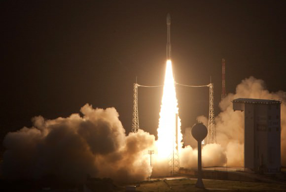
Vega’s story began on February 13, 2012, when the rocket made its inaugural flight from Europe’s Spaceport in French Guiana. This mission was a qualification flight, successfully deploying nine science cubesats into Earth orbit. The maiden flight set the stage for Vega’s future as a dependable launch vehicle.

“Vega’s maiden flight marked the start of a new chapter in European space launch capabilities. Its success was a testament to the innovation and dedication of the teams involved.” — ESA

Key Missions

Throughout its operational life, Vega played a crucial role in several high-profile missions:

LISA Pathfinder (2015)

One of Vega’s standout missions was launching LISA Pathfinder in 2015. This mission aimed to demonstrate technology for detecting gravitational waves in space, paving the way for future space-based observatories.

Proba-V (2013)

In 2013, Vega launched Proba-V, an Earth observation satellite tasked with monitoring vegetation growth across the globe. This mission was significant for its role in environmental monitoring and climate studies.

Aeolus (2018)

The Aeolus mission, launched in 2018, was another notable achievement. It aimed to measure the global wind profiles, providing valuable data for weather forecasting and climate research.

The Final Vega Rocket Launch: A Look at the End of an Era in Space Travel
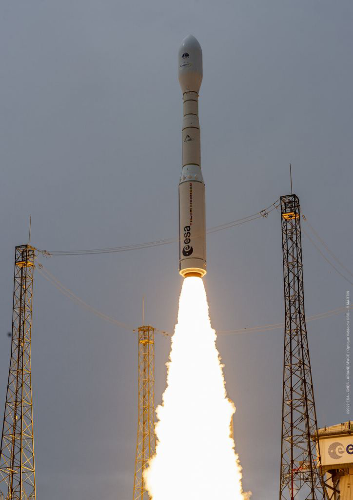
A Vega-C rocket launched into space. It carried the Lares-2 mission and several smaller satellites, called rideshares. Credit: ESA

Technical Specifications

Vega stood 30 meters tall and weighed 137 tons on the launch pad. It consisted of three solid-propellant stages and a liquid-propellant fourth stage. The rocket’s design allowed it to reach space in just six minutes, making it a swift and efficient launcher for smaller payloads.

Feature Details
Height 30 meters (98 ft)
Weight 137 tons
Stages 3 solid-propellant, 1 liquid-propellant
Time to Orbit 6 minutes

Notable Achievements

2020: The Largest Payload

In 2020, Vega achieved its highest payload capacity by using a variant of the Vespa adapter called the Small Spacecraft Mission Service. This flight successfully delivered over 50 satellites to orbit, showcasing Vega’s versatility and capability.

IXV Reentry Demonstrator (2015)

Vega’s 2015 mission included the launch of the IXV (Intermediate eXperimental Vehicle), a reentry demonstrator. This mission was critical for testing technology related to reentry and safe return of spacecraft.

“Vega’s role in launching the IXV demonstrated its ability to support cutting-edge space technology and pave the way for future space missions.” — ESA

Transition to Vega-C

As Vega retires, the European Space Agency is transitioning to the Vega-C rocket. Vega-C represents a significant upgrade, offering improved performance and increased payload capacity. The inaugural flight of Vega-C took place in July 2022, successfully launching the LARES-2 satellite and six research CubeSats.

Improvements in Vega-C

Vega-C features several enhancements over its predecessor:

  • Two New Solid Propulsion Stages: Improved thrust and performance.
  • Uprated Fourth Stage: Enhanced capability for deploying payloads into their desired orbits.
  • Newly Designed Fairing: Increased payload capacity and protection.
  • Upgraded Ground Infrastructure: Enhanced support for launches and operations.
Vega Vega-C
Solid Stages 3
Payload Capacity Lower compared to Vega-C
Fairing Design Older design
Ground Infra. Standard

With Vega’s retirement, ESA is ready to tackle new challenges and opportunities with the Vega-C rocket. Vega-C will take over missions that were previously assigned to Vega. It will also offer better abilities for future space exploration and satellite deployment.

The final Vega rocket launch on September 5, 2024, marks the end of an important era in European space travel. Vega’s legacy is one of reliability and innovation, having supported numerous scientific and Earth observation missions. As ESA transitions to the Vega-C rocket, the future looks promising with improved capabilities and performance. The final Vega launch is a reminder of the progress made in space technology and the continuous effort to advance space exploration.

The Final Vega Rocket Launch: A Look at the End of an Era in Space Travel
On 13 February 2012, the first Vega rocket took off on its first flight. It launched from Europe’s South American Spaceport in French Guiana. The rocket successfully put 9 science satellites into space. Credits: ESA – S. Corvaja

References:

  1. ESA Vega-C Success
  2. ESA Farewell to Vega
  3. Sentinel Missions
  4. Aeolus Mission
  5. Proba-V Mission
  6. LISA Pathfinder Overview

#VegaRocket, #SpaceTravel, #ESA, #VegaC, #Sentinel2C, #EarthObservation, #SpaceLaunch, #RocketScience, #EuropeanSpaceAgency, #SpaceExploration, #LISAPathfinder, #ProbaV, #Aeolus, #CubeSats, #SpaceHistory

China Launches New Advanced Earth Observation Satellite

Key Takeaways

China successfully launched the Gaofen-11 05 satellite on July 19, 2024, using the Great Trek launch vehicle. The satellite will conduct detailed Earth observations, aiding in land resource studies, urban planning, and disaster early warning. The satellite is part of China’s “One Belt, One Road” initiative, providing services to various countries. This launch marks the 528th successful mission of the Great Campaign series.

Summary

  • Launch Details:
    • Date: July 19, 2024
    • Time: 11:03 local time
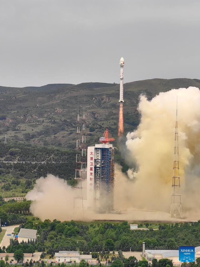
    • Location: Taiyuan station, Shaanxi Province
    • Vehicle: Great Trek launch vehicle
  • Satellite Information:
    • Name: Gaofen-11 05
    • Developed by: Chinese Space Science and Technology Corporation
    • Orbit: Successfully reached planned orbit
  • Purpose and Applications:
    • Land resource study
    • Urban planning
    • Road network planning
    • Crop productivity assessment
    • Natural disaster early warning
  • International Collaboration:
    • Part of the “One Belt, One Road” initiative
    • Provides services to multiple countries
  • Historical Context:
    • 528th launch of the Great Campaign series

Main Article

China continues to make significant strides in space technology with the recent launch of the Gaofen-11 05 satellite. This event, which took place on July 19, 2024, marks another milestone in China’s ambitious space program, highlighting the nation’s growing capabilities in Earth observation and satellite technology. The launch, carried out from Taiyuan station in Shaanxi Province using the Great Trek launch vehicle, was a success, with the satellite reaching its intended orbit.

The Gaofen-11 05 Satellite

The Gaofen-11 05 satellite is a cutting-edge Earth observation satellite developed by the Chinese Space Science and Technology Corporation. It is designed to provide high-resolution images of the Earth’s surface, supporting various applications such as land resource studies, urban planning, road network planning, crop productivity assessment, and early warning of natural disasters. The satellite’s advanced technology allows it to capture detailed images, making it an invaluable tool for researchers and planners.

Technical Specifications

Specification Details
Developer Chinese Space Science and Technology Corporation
Launch Vehicle Great Trek
Launch Date July 19, 2024
Launch Time 11:03 local time
Launch Site Taiyuan station, Shaanxi Province
Orbit Planned orbit achieved

Applications and Benefits

Land Resource Studies

The Gaofen-11 05 satellite will significantly enhance land resource studies by providing detailed images that can be used to monitor and manage natural resources. These images help in identifying changes in land use, deforestation, and other environmental impacts. Accurate data from the satellite can guide policymakers in making informed decisions about land management and conservation.

Urban Planning

Urban planners will benefit immensely from the high-resolution images provided by the Gaofen-11 05 satellite. These images allow for precise mapping of urban areas, helping in the design and development of infrastructure. Planners can use the data to optimize land use, improve transportation networks, and ensure sustainable development in rapidly growing cities.

Road Network Planning

Efficient road network planning is crucial for economic development and reducing traffic congestion. The satellite’s imagery helps planners identify the best routes for new roads and highways, assess the condition of existing infrastructure, and plan for future expansions. This leads to better connectivity and improved transportation efficiency.

Crop Productivity Assessment

Agricultural productivity is vital for food security, and the Gaofen-11 05 satellite plays a crucial role in monitoring crop health and productivity. By providing detailed images of agricultural lands, the satellite helps farmers and researchers assess crop conditions, identify areas requiring attention, and optimize farming practices. This leads to increased yields and better resource management.

Natural Disaster Early Warning

One of the most critical applications of the Gaofen-11 05 satellite is in the early warning of natural disasters. The satellite can detect changes in the environment that may indicate the onset of disasters such as floods, landslides, and earthquakes. Early detection allows for timely evacuation and mitigation measures, potentially saving lives and reducing property damage.

International Collaboration: “One Belt, One Road” Initiative

The Gaofen-11 05 satellite is not just a national asset but also a tool for international collaboration. It is part of China’s “One Belt, One Road” initiative, which aims to enhance connectivity and cooperation among countries along the historical Silk Road routes. By providing satellite services to these countries, China is fostering stronger ties and contributing to global development.

Historical Context and Future Prospects

The launch of the Gaofen-11 05 satellite marks the 528th successful mission of the Great Campaign series. This series has been instrumental in advancing China’s space capabilities, contributing to various scientific and commercial achievements. The success of these missions reflects China’s commitment to becoming a leading space power.

Historical Launch Data

Launch Number Date Satellite Name Vehicle Success Rate
528 July 19, 2024 Gaofen-11 05 Great Trek 100%
527 June 15, 2024 Fengyun-3E Long March 98%
526 May 10, 2024 Beidou-3GEO Long March 97%

Conclusion

China’s successful launch of the Gaofen-11 05 satellite is a testament to the country’s advancements in space technology and its dedication to enhancing Earth observation capabilities. The satellite’s applications in land resource studies, urban planning, road network planning, crop productivity assessment, and natural disaster early warning demonstrate its multifaceted utility. Moreover, as part of the “One Belt, One Road” initiative, the satellite will foster international collaboration and contribute to global development. This launch not only marks a significant milestone in China’s space program but also sets the stage for future innovations and achievements.

Hashtags

#ChinaSpaceProgram, #Gaofen11, #EarthObservation, #SatelliteLaunch, #SpaceTechnology, #UrbanPlanning, #NaturalDisasters, #OneBeltOneRoad, #GlobalDevelopment
Pin It
error: Content is protected !!

This website utilizes first- and third-party tools that store small files (cookies) on your device. These cookies serve various purposes, including ensuring the site functions correctly (technical cookies), analyzing site usage (analytics cookies), and delivering relevant advertisements (profiling cookies). While technical cookies are essential and used by default, you have the option to enable or disable analytics and profiling cookies. By allowing these cookies, you help us enhance your browsing experience.