Author

Jonathan Bala

Browsing

Solar Max Update: Sun Releases Three X-Class Flares

Key Takeaway:

The Sun is intensifying its activity as it approaches solar maximum, evident from the recent release of three X-class solar flares. Solar flares, categorized based on their strength, pose various risks to Earth’s communications, power grids, spacecraft, and astronauts. Predicting solar maximum is challenging but estimates suggest it will likely occur between May 2024 and early 2026. Understanding solar activity is crucial, and advancements in technology are aiding scientists in studying and predicting solar cycles.

Summary:

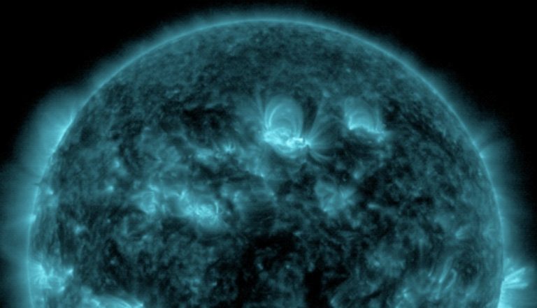
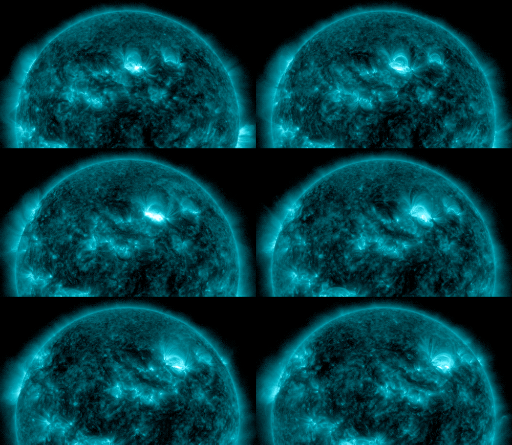
  • The Sun released three X-class solar flares within a 24-hour period on May 5 and May 6, 2024.
  • Solar flares can disrupt radio communications, electric power grids, and pose risks to spacecraft and astronauts.
  • NOAA’s Space Weather Prediction Center (SWPC) estimates solar maximum to occur between May 2024 and early 2026.
  • Solar flares are explosions on the Sun caused by magnetic energy associated with sunspots.
  • Flares are classified based on strength, with X-class being the most intense.
  • Solar flares are often accompanied by coronal mass ejections (CMEs), which can produce auroras on Earth.
  • Missions like the Solar Dynamics Observatory, Solar Orbiter, and Parker Solar Probe provide valuable insights into the Sun’s behavior.
Solar Max Update Sun Releases Three X-Class Flares
blogs.nasa.gov/solarcycle25/2024/05/06/sun-releases-three-strong-flares/

Sun Releases Three X-Class Flares

The recent surge in solar activity, marked by the release of three X-class solar flares in just over a 24-hour period, has brought renewed attention to the Sun’s impending transition towards solar maximum. As the Sun continues its journey through its 11-year activity cycle, scientists and space agencies are closely monitoring these developments, recognizing the potential impacts on Earth and space-based technologies.

These recent flares, measuring at X1.3, X1.2, and X4.5, highlight the Sun’s increasing activity as it progresses towards its peak in solar maximum. The classification of solar flares, similar to the Richter scale for earthquakes, categorizes them based on their strength and energy output. X-class flares represent the most intense category, with each successive letter indicating a tenfold increase in energy.

Understanding the potential impacts of solar flares is crucial for reducing their effects on Earth’s technology and infrastructure. Radio communications and electric power grids are particularly vulnerable to the effects of solar activity. Additionally, spacecraft and astronauts in space face increased risks from heightened radiation levels during solar events.

The Space Weather Prediction Center (SWPC) at NOAA plays a crucial role in forecasting solar activity and its potential impacts. While predicting solar maximum with precision remains challenging, ongoing efforts by scientists and researchers aim to improve our understanding of solar cycles and enhance predictive capabilities.

The recent advancements in solar observation technologies have greatly contributed to our understanding of the Sun’s behavior. Missions such as the Solar Dynamics Observatory (SDO), Solar Orbiter, and Parker Solar Probe provide unprecedented views of the Sun’s surface, allowing scientists to study solar phenomena in detail.

As the Sun continues its journey towards solar maximum, scientists and space agencies remain vigilant, utilizing cutting-edge technologies and collaborative efforts to monitor and understand solar activity. By studying the Sun’s behavior, we can better prepare for and mitigate the potential impacts of solar events on Earth and in space.

Hashtags:

#SolarMax, #SolarFlares, #SpaceWeather, #NASA, #NOAA, #SunScience #Solar Max

Source: blogs.nasa.gov/solarcycle25/2024/05/06/sun-releases-three-strong-flares/

Earth’s Shield Collapsed 41,000 Years Ago

Summary

A study on the Laschamps excursion, an event 41,000 years ago when Earth’s magnetic shield weakened, reveals that the transition from normal to reversed field took 250 years and stayed reversed for about 440 years. During this period, the shield weakened to 25% of its normal strength, allowing more cosmogenic radionuclides to reach Earth’s surface. The weakening of the shield also affected the ozone layer, climate, and wind patterns. Although the event has been linked to extinctions and cave art, the effects of cosmic rays when the shield is weak remain uncertain.

Key Takeaways

  • The Laschamps excursion occurred 41,000 years ago when Earth’s magnetic shield weakened, allowing cosmic rays to reach the atmosphere.
  • Radionuclides from cosmic rays were embedded in sediments, ice cores, and living things.
  • The Earth’s magnetic field transitioned from normal to reversed over 250 years and remained reversed for around 440 years.
  • The weakening of the shield affected the ozone layer, climate, and wind patterns.
  • The Laschamps event has been linked to extinctions and cave art, but these links lack strong scientific evidence.
  • The effect of cosmic rays on life when the shield is weak is uncertain.
  • The magnetic shield is not static, and anomalies like the South Atlantic Anomaly exist.
Earth's Shield Collapsed 41,000 Years Ago
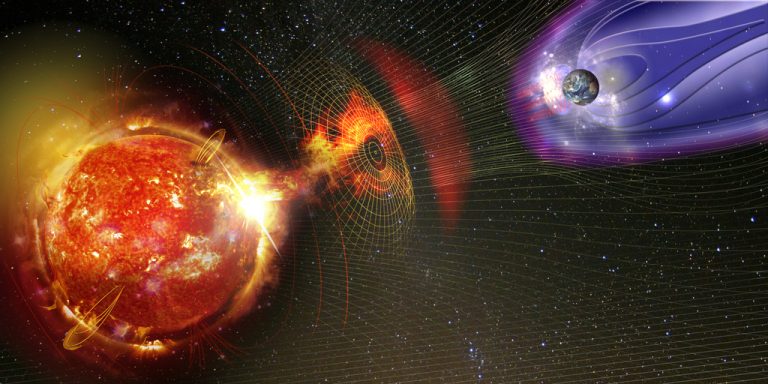
Magnetic lines of force surrounding Earth known as the magnetosphere deflecting solar wind and radiation from the Sun. Elements of this image furnished by NASA.

Earth’s Shield Collapsed 41,000 Years Ago

Earth is vulnerable without its protective barrier. This barrier is the planet’s magnetic shield, which keeps cosmic rays at bay. However, occasionally, this shield weakens and fluctuates. When this happens, cosmic rays penetrate and hit the atmosphere, generating a shower of particles. Scientists believe these particles could significantly damage the biosphere.

One example occurred 41,000 years ago during an event known as the Laschamps excursion.

Cosmic rays are high-energy particles, typically protons or atomic nuclei, that travel at extremely high speeds. Under normal conditions, the Earth’s magnetic shield deflects these away from the planet. But the shield can change in strength and orientation, allowing cosmic rays to strike the Earth’s atmosphere.

Earth's Shield Collapsed 41,000 Years Ago
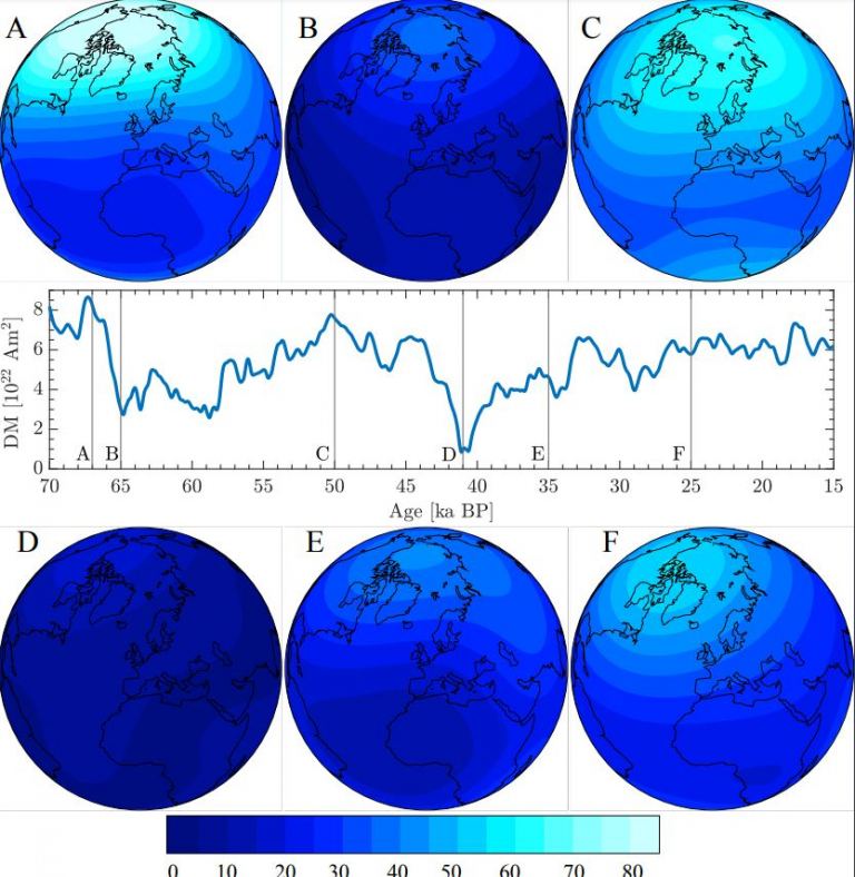
Each map displays the intensity of Earth’s geomagnetic field at different moments in time. These maps are based on reconstructions by Panovska. They use paleomagnetic data and records of cosmogenic beryllium-10 radionuclides. DM stands for Dipole Moment. This measures the field’s polarity, indicating the separation of positive and negative charges. Age [ka BP] represents the map’s age in thousands of years before the present. Image credit goes to Sanja Panovska.
This interaction produces a spray of secondary particles called cosmogenic radionuclides. These isotopes are found in sediments, ice cores, and even within the structures of trees. They include various types, such as Calcium 41 and Carbon 14.

These isotopes vary in stability. Some are stable, while others are radioactive, with half-lives ranging from 20 minutes for Carbon 11 to 15.7 million years for Xenon 129.

When the Earth’s magnetic shield weakens, more isotopes reach and accumulate on the surface. By studying sediment and ice cores, scientists can track the history of the magnetic shield. Research shows that there was a geomagnetic excursion or reversal, called the Laschamps excursion, identified through geomagnetic anomalies in the Laschamps lava flows in France.

Earth's Shield Collapsed 41,000 Years Ago
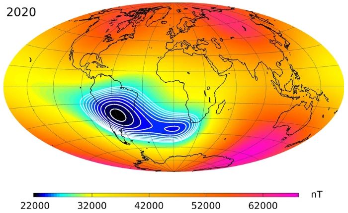
The ‘South Atlantic Anomaly’ is an area where Earth’s magnetic shield is weaker. This information comes from a study by Christopher C. Finlay and colleagues. The study is titled “The CHAOS-7 geomagnetic field model and observed changes in the South Atlantic Anomaly”. It was published in Earth, Planets, and Space in 2020. You can find it under article number 156. The image showing the anomaly is credited under CC BY-SA 4.0.

The Earth’s magnetic poles typically flip every few hundred thousand years, switching North to South and vice versa. Between these flips are lesser events known as excursions, where the poles drift without fully switching. These excursions can last from a few thousand up to tens of thousands of years, weakening the Earth’s shield and allowing more cosmic rays to hit the atmosphere, thereby increasing radionuclide production.

Scientists, in paleomagnetic studies, often focus on Beryllium 10. This isotope, with a half-life of 1.36 million years, accumulates on the soil surface.

Sanja Panovska, a geomagnetism researcher at GFZ Potsdam, Germany, presented findings on the Laschamps excursion at the European Geosciences Union General Assembly in 2024. She reported that during this period, production of Beryllium 10 doubled. She combined data on cosmogenic radionuclides and paleomagnetic studies to reconstruct the magnetic field at that time. Her findings indicated that the magnetic field weakened to 5% of its normal strength during the transition to a reversed field, which lasted about 250 years. The field stayed reversed for about 440 years and operated at about 25% of its regular strength during that period. This significant weakening allowed more cosmogenic radionuclides to reach Earth’s surface.

These isotopes not only accumulate in sediments and ice, but also impact the ozone layer and climate. Lowering the shield and the ozone layer allows more UV radiation to reach us, cooling the high-altitude atmosphere and altering wind flows, possibly causing severe changes on Earth’s surface.

This event, the Laschamps excursion, has been suggested as a factor contributing to significant events like the extinction of Neanderthals and the emergence of cave art. Although these correlations lack robust scientific support, such events pose real risks; a similar modern occurrence could disrupt power grids and cause widespread auroras in equatorial regions.

Panovska stressed the importance of understanding these extreme events for predicting future space climate and assessing environmental impacts.

The magnetic shield displays anomalies, like the South Atlantic Anomaly, where the field is weakest. This affects satellites, exposing them to higher radiation levels, showing the complex nature of Earth’s magnetic field.

Understanding the impact of cosmic rays during periods when the magnetic shield is weak is crucial. Although it’s tempting to link events like the Laschamps excursion with major extinctions directly, the relationship is not straightforward since life continues despite numerous shifts and reversals in the magnetic poles.

Hashtags:

#EarthScience, #Geology, #MagneticShield, #ClimateChange, #CosmicRays #Earth’s Shield Collapsed

Dive into a Black Hole with NASA’s New Simulation

Summary

NASA created a simulation using a supercomputer to visualize what it would be like to fall into a black hole, offering two scenarios: one where the camera crosses the event horizon and another where it escapes. The simulation shows the effects of strong gravity and time dilation near a black hole, emphasizing the dangers of spaghettification and the time differences experienced by those who approach black holes. The simulations were created in a short time frame using NASA’s Discover supercomputer.

Key Takeaways

  • NASA used a supercomputer to create a simulation of falling into a black hole.
  • The simulation offers two scenarios: crossing the event horizon or escaping.
  • The black hole in the simulation is the same size as Sagittarius A star, the supermassive black hole at the center of the Milky Way.
  • Falling into a supermassive black hole would be preferable to a stellar-mass black hole due to milder tidal forces.
  • The simulation highlights spaghettification, a stretching effect caused by the strong gravitational pull of black holes.
  • Time dilation near a black hole results in significant time differences relative to distant observers.
  • The simulations were created in a short time period using NASA’s Discover supercomputer.

Dive into a Black Hole with NASA’s New Simulation

NASA has developed a simulation to help us visualize what it would be like to fall into a black hole. The simulation, created by astrophysicist Jeremy Schnittman at NASA’s Goddard Space Flight Center, consists of two scenarios: one where a camera plunges into the black hole and another with a 360-degree view. The simulation was generated using a NASA supercomputer called Discover, producing 10 terabytes of data in just five days. This visualization focuses on a supermassive black hole, such as the one at the center of our Milky Way galaxy, known as Sagittarius A.

Schnittman explains that if given the choice, falling into a supermassive black hole would be preferable to a stellar-mass black hole. Stellar-mass black holes, which are less massive and have smaller event horizons, possess stronger tidal forces that can tear apart approaching objects. The simulation showcases the phenomenon of spaghettification, where the intense gravity of a black hole stretches and elongates objects.

In the simulation, the camera starts its journey at a distance of 640 million kilometers (400 million miles) from the black hole. As the camera falls closer, the images of the sky, the black hole’s disk, and the photon ring become warped due to the curvature of space-time. It takes the camera three hours of real-time to reach the event horizon, during which it completes nearly two 30-minute orbits. From a distant observer’s perspective, the camera freezes at the event horizon, never appearing to cross it.

Once an object crosses the event horizon, it and space-time itself reach the speed of light. After crossing the horizon, the object moves swiftly towards the singularity, a point of infinite density and gravity. The simulation reveals that once the camera surpasses the event horizon, it would face destruction by spaghettification a mere 12.8 seconds later.

The second video in the simulation showcases the camera’s escape from the black hole, highlighting the time dilation effect. If the camera were an astronaut making a six-hour roundtrip near a strongly rotating black hole, they would return to find themselves 36 minutes younger than their peers who stayed further away.

The simulation created by NASA provides insights into the experience of falling into a black hole. It emphasizes the dangers associated with approaching these cosmic entities, highlighting the warping of space-time, spaghettification, and time dilation effects. Falling into a black hole is an extremely hazardous endeavor, and it is advised to leave such encounters to the realm of physics and scientific exploration.

Hashtags:

#blackhole, #NASA, #cosmos, #spaceexploration, #astrophysics

Six Advanced Tech Concepts by NASA Reach Phase II

Key Takeaway:

NASA’s NIAC program has selected six cutting-edge concepts for Phase II development, each receiving $600,000 in funding. These concepts range from fluidic telescopes to innovative propulsion systems and promise to revolutionize space exploration in the coming years.

Summary:

  • Fluidic Telescope (FLUTE): Introduces fluid-based mirrors for space telescopes, potentially revolutionizing large observatories.
  • Pulsed Plasma Rocket (PPR): Aims to drastically reduce travel time to Mars with shielded, fast transit propulsion.
  • The Great Observatory for Long Wavelengths (GO-LoW): Proposes a vast array of Small-Sats to explore low-frequency radio waves from space.
  • Radioisotope Thermoradiative Cell Power Generator: Offers efficient power generation for outer planet missions using radioisotope heat.
  • FLOAT: Introduces a flexible levitation track system for autonomous transportation on the lunar surface.
  • SCOPE: Combines a solar sail with a spectrometer for outer planet exploration, promising rapid travel and data collection.
Six Advanced Tech Concepts by NASA Reach Phase II
The team behind FLOAT plans to build the first railway on the Moon. It will be unique in design. An artist’s concept illustrates this potential future mission. The image shows the lunar surface with planet Earth visible on the horizon. Ethan Schaler received credit for this image.

NASA’s Innovative Concepts Forge the Path to Future Space Exploration

In the rapidly changing field of space exploration, NASA’s Innovative Advanced Concepts (NIAC) program stands out as a beacon of innovation. It’s a platform where groundbreaking ideas are nurtured, ideas that have the potential to reshape the future of space missions. Recently, six such pioneering concepts have progressed to Phase II development, signifying a major stride forward in their path to becoming a reality.

One such concept, the Fluidic Telescope (FLUTE), challenges traditional telescope design by harnessing the unique properties of fluids in microgravity to create expansive mirrors. According to project lead Edward Balaban,

“FLUTE envisions a paradigm shift in space observatories, offering larger apertures and self-repair capabilities.”

Six Advanced Tech Concepts by NASA Reach Phase II
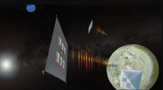
This artist’s depiction displays ScienceCraft. It combines the science instrument with the spacecraft. A quantum dot spectrometer is printed directly on the solar sail. This creates a single, lightweight structure.
Image Credit: Mahmooda Sultana

In a similar vein, the Pulsed Plasma Rocket (PPR) aims to revolutionize interplanetary travel, with the potential to cut the journey time to Mars in half. Brianna Clements, the project lead, highlights the significance of this advancement, stating, “PPR opens up new horizons for human exploration beyond Earth’s orbit.

Meanwhile, the Great Observatory for Long Wavelengths (GO-LoW) proposes a novel approach to studying low-frequency radio waves from space. Mary Knapp, leading the project, emphasizes the collaborative nature of GO-LoW, stating,

“Our goal is to unlock the mysteries of the universe by harnessing the power of a vast satellite array.”

The Radioisotope Thermoradiative Cell Power Generator offers a compact and efficient power source for outer planet missions, addressing the challenges of powering spacecraft in the distant reaches of our solar system. Project lead Stephen Polly underscores the potential of this technology, stating, “RTCPG represents a game-changer for missions beyond Mars, offering unparalleled reliability and efficiency.

On the lunar front, the FLOAT concept introduces a revolutionary transport system for payloads on the Moon’s surface. Ethan Schaler, leading the project, envisions a future where “FLOAT facilitates seamless movement of resources, laying the groundwork for sustainable lunar exploration.”

Six Advanced Tech Concepts by NASA Reach Phase II
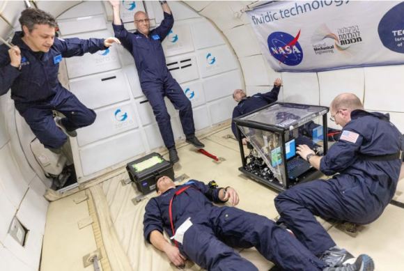
FLUTE researchers experience microgravity on the Zero Gravity Corporation’s G-FORCE ONE aircraft. They operate an experimental payload during a series of parabolic flights. Image Credits: Zero Gravity Corporation/Steve Boxall

Lastly, SCOPE presents a pioneering approach to outer planet exploration, combining propulsion and instrumentation in a single, lightweight structure. Mahmooda Sultana, leading the project, envisions a future where

“ScienceCraft enables rapid transit and data collection, unlocking the mysteries of distant worlds.”

As these concepts advance to Phase II development, they herald a new era of possibility in space exploration, pushing the boundaries of what we thought possible. With NASA’s unwavering support and the ingenuity of visionary scientists and engineers, the stars seem closer than ever before.

Six Advanced Tech Concepts by NASA Reach Phase II
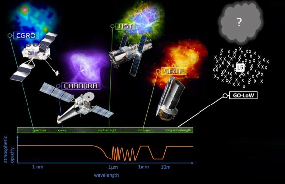
GO-LoW is a Great Observatory designed to explore the last unexplored part of the electromagnetic (EM) spectrum. The Earth’s ionosphere blocks wavelengths around 10 meters, making them opaque. Therefore, GO-LoW will be placed in space alongside other Great Observatories, such as HST and JWST. This positioning will allow it to access this specific spectral window. Image Credits: NASA/GO-LoW

Hashtags:

#SpaceExploration, #NASA #Innovation, #FutureTech, #AdvancedConcepts #Six Advanced Tech Concepts #Six Advanced Tech Concepts

Update on Solar System’s Ghost: Planet Nine

Key Takeaway:

Scientists continue to gather evidence suggesting the existence of a mysterious ninth planet in our Solar System, dubbed Planet Nine. Recent research by astronomers Mike Brown and Konstantin Batygin, along with their colleagues, presents compelling data supporting the presence of this elusive celestial body.

Through careful simulations and analysis of Trans-Neptunian Objects (TNOs), they offer tantalizing clues about Planet Nine’s potential influence on the outer reaches of our Solar System. While the hunt for Planet Nine remains ongoing, the findings underscore the dynamic nature of scientific inquiry and the quest to unravel the mysteries of our cosmic neighborhood.

Summary:

  • Planet Nine, a hypothetical planet in the outskirts of our Solar System, was first proposed in 2016 by astronomers Mike Brown and Konstantin Batygin.
  • Evidence supporting Planet Nine’s existence stems from the clustering of orbits of Extreme Trans-Neptunian Objects (ETNOs).
  • Recent research led by Brown, Batygin, Morbidelli, and Nesvorny presents further evidence through N-body simulations of Trans-Neptunian Objects (TNOs).
  • These simulations suggest that the gravitational influence of Planet Nine could explain the unique orbits of certain TNOs.
  • While the evidence is compelling, it falls short of definitive proof, leaving room for alternative explanations such as the Galactic Tide or cluster dynamics.
  • The upcoming Vera Rubin Observatory could provide crucial data to test the existence of Planet Nine.
  • If confirmed, the nature of Planet Nine—whether it’s a remnant of the Solar System’s early days, a rogue planet, or a captured object—remains an intriguing question in astronomy.
Update on Solar System's Ghost Planet Nine
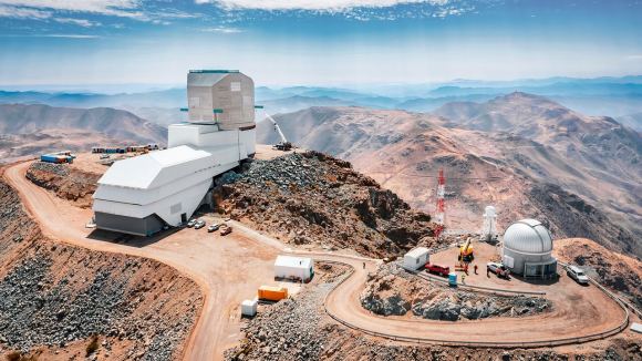
The Rubin Observatory is being constructed and was viewed by a drone in 2023. It features an 8.4-meter telescope. The construction is nearing completion, aiming for its first light in 2025. This observatory might help solve several major questions, such as whether Planet Nine exists. Image Credit: Rubin Observatory/NSF/AURA/A. Pizarro D

Update on Solar System’s Ghost: Planet Nine

Does another undetected planet languish in our Solar System’s distant reaches? Does it follow a distant orbit around the Sun in the murky world of comets and other icy objects? For some researchers, the answer is “almost certainly.”

The case for Planet Nine (P9) goes back at least as far as 2016. In that year, astronomers Mike Brown and Konstantin Batygin published evidence pointing to its existence. Along with colleagues, they’ve published other work supporting P9 since then.

“The solar system’s distant reaches exhibit a wealth of anomalous dynamical structure, hinting at the presence of a yet-undetected, massive trans-Neptunian body—Planet Nine (P9).” – Brown et al.

Update on Solar System's Ghost Planet Nine
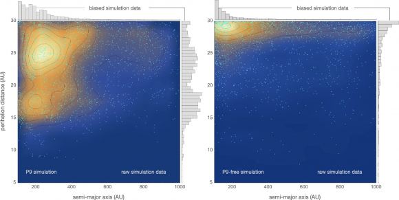
The image from the study displays the closest approach to the Sun (perihelion distance) for particles in two scenarios: one with Planet Nine (P9) included (left) and one without P9 (right). The simulation without P9 reveals a quick drop in the number of particles as their distance to the Sun decreases. This is because Neptune’s orbit creates a significant dynamic barrier, the researchers note. Image Credit: Batygin et al. 2024.

There’s lots of evidence for the existence of P9, but none of it has reached the threshold of definitive proof. The main evidence concerns the orbits of Extreme Trans-Neptunian Objects (ETNOs). They exhibit a peculiar clustering that indicates a massive object. P9 might be shepherding these objects along on their orbits.

The names Brown and Batygin, both Caltech astronomers, come up often in regard to P9. Now, they’ve published another paper along with colleagues Alessandro Morbidelli and David Nesvorny, presenting more evidence supporting P9.

Their paper, titled “Generation of Low-Inclination, Neptune-Crossing TNOs by Planet Nine,” is published in The Astrophysical Journal Letters.

Update on Solar System's Ghost Planet Nine
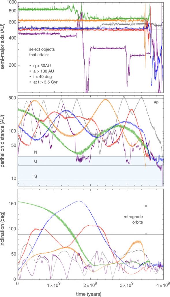
The panels show the evolution of selected particles. These particles achieve nearly flat (i < 40°) orbits that cross Neptune’s path in the last 500 million years of the study. The researchers state, “Collectively, these examples indicate that P9-facilitated dynamics can naturally produce objects similar to those depicted in Figure 1.” The panels are organized as follows: the top panel shows the semimajor axis over time, the middle panel shows the perihelion distance, and the bottom panel shows the inclination. The rate at which the particles’ paths change unpredictably increases when they start crossing Neptune’s orbit. Image Credit: Batygin et al. 2024.

To dig deeper into the issue, Batygin, Brown, Morbidelli, and Nesvorny examined Trans-Neptunian Objects (TNOs) with more conventional orbits. They carried out N-body simulations of these objects that included everything from the tug of giant planets and the Galactic Tide to passing stars.

The researchers’ goal was to analyze these objects’ origins and determine if they could be used as a probe for P9. To accomplish this, they conducted two separate sets of simulations: one with P9 in the Solar System and one without.

Update on Solar System's Ghost Planet Nine
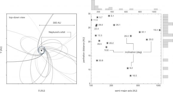
This image from Batygin et al. 2024 displays 17 planets. It illustrates their orbits, perihelions, and semi-major axes. It also shows the inclination of each planet. Image Credit: Batygin et al. 2024.

These simulations yielded interesting results. They showed that the presence of P9 could indeed explain the observed orbital dynamics of certain TNOs. The simulations began at t=300 million years, meaning 300 million years into the Solar System’s existence. At that time, “intrinsic dynamical evolution in the outer solar system is still in its infancy,” the authors explain, while enough time has passed for the Solar System’s birth cluster of stars to disperse and for the giant planets to have largely concluded their migrations.

An important result of this work is that it results in falsifiable predictions. And we may not have to wait long for the results to be tested.

“Excitingly, the dynamics described here, along with all other lines of evidence for P9, will soon face a rigorous test with the operational commencement of the VRO (Vera Rubin Observatory).” – Brown et al.

Update on Solar System's Ghost Planet Nine
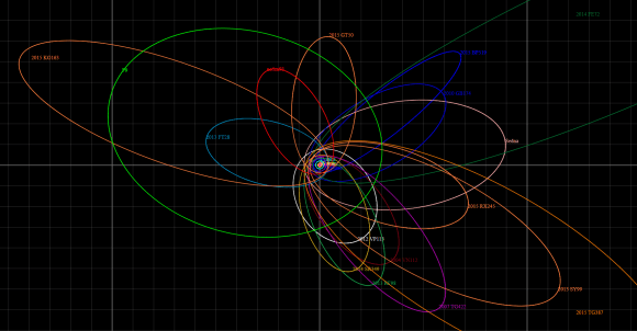
This orbital diagram features Planet Nine, shown in lime green and labeled “P9.” It also includes several extreme trans-Neptunian objects. The background is divided into squares, each measuring 100 AU across. Image credit: Tomruen – Own work, CC BY-SA 4.0, available at https://commons.wikimedia.org/w/index.php?curid=68955415

If P9 is real, what is it? It could be the core of a giant planet ejected during the Solar System’s early days. It could be a rogue planet that drifted through interstellar space until being caught up in our Solar System’s gravitational milieu. Or it could be a planet that formed on a distant orbit, and a passing star shepherded it into its eccentric orbit.

But the big question dominates for now and likely will for a while longer: Is there a Planet Nine?

Hashtags:

#PlanetNine, #Astronomy, #Cosmology, #SpaceExploration, #ScientificInquiry

What Early Earth Teaches Us About Finding Life

Key Takeaway:

The study of early Earth provides a fascinating glimpse into the conditions that existed billions of years ago, offering valuable insights into the origins of life on our planet. By examining the harsh environments in which life thrived and the chemical processes that gave rise to living organisms, scientists can draw parallels to the search for life beyond Earth.

Summary:

  • Earth’s atmosphere has changed significantly over its 4.5 billion years of existence.
  • Research on early Earth’s biogeochemistry helps in evaluating exoplanetary potential for life.
  • Earth’s microbial biosphere thrived under different atmospheric conditions, providing insights into remote detection of life.
  • Plate tectonics and atmospheric processes have influenced Earth’s atmosphere over time.
  • Lessons from Earth include the presence of multiple atmospheric stages, altered rock records, delayed detection of oxygen, and the impact of plate tectonics on chemistry.
  • Remote detection of exoplanetary biospheres relies on telescopic observations of atmospheric composition.
  • Advanced telescopes like the JWST are enhancing our ability to detect chemicals in exoplanet atmospheres.
  • Future tools may enable the recognition of surface features indicative of life.
  • Earth serves as a model for understanding and accelerating the search for life beyond our solar system.
What Early Earth Teaches Us About Finding Life
The JWST has been in the news for its work on exoplanet atmospheres and the detection of chemicals. On July 10, 2022, the telescope’s Near-Infrared Spectrograph (NIRSpec) recorded a transmission spectrum from the hot gas giant exoplanet WASP-39 b. This data showed the first clear evidence of carbon dioxide in the atmosphere of a planet beyond our Solar System. The image credits go to NASA, ESA, CSA, and L. Hustak from STScI. The responsible scientific team is the JWST Transiting Exoplanet Community Early Release Science Team.

Exploring Early Earth: Lessons for the Search for Life

Earth stands as a unique oasis of life in the vast expanse of the cosmos. Its evolution over billions of years offers a window into the potential for life on other planets. By Decoding the mysteries of Earth’s past, scientists gain valuable insights into how to search for life beyond our solar system.

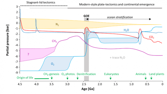
Earth’s atmosphere has experienced significant changes since it first formed 4.5 billion years ago. Initially, it lacked oxygen and was described as anoxic. Over time, a series of geological and biological processes reshaped the atmosphere. One crucial event, known as the Great Oxygenation Event, occurred approximately 2.4 billion years ago. During this event, oxygen began to accumulate in the atmosphere, primarily due to the emergence of photosynthetic organisms.

“Earth’s atmospheric composition is very strongly controlled by life.” – Research findings

What Early Earth Teaches Us About Finding Life
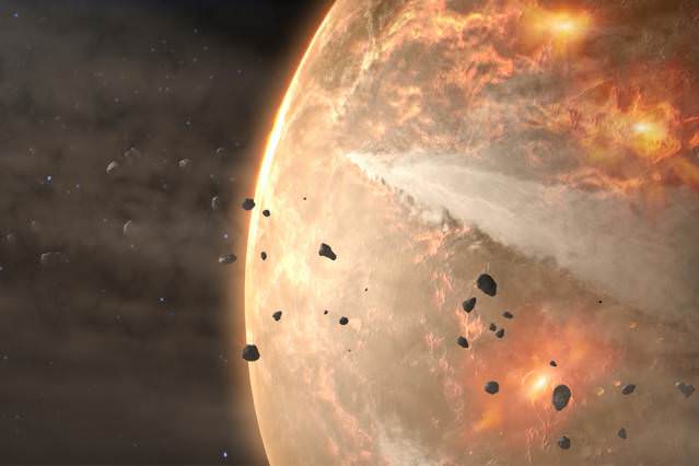
The Hadean Eon on Earth remains largely mysterious due to the lack of geological evidence from that period. In this era, Earth first gained its atmosphere from the surrounding solar nebula. However, it quickly lost this initial atmosphere. As the planet began to cool, gases released from within formed a new atmosphere. Credit: NASA

Lessons from Earth’s Biogeochemical Evolution

  1. Multiple Atmospheric Stages: Earth has experienced three distinct atmospheres, each influenced by different factors such as outgassing and biological activity. Understanding these stages provides a framework for evaluating exoplanetary atmospheres.
  2. Altered Rock Records: Geological evidence of early life on Earth is scarce due to the alteration and destruction of rock records over time. This challenges our ability to reconstruct the early biosphere accurately.
  3. Delayed Oxygen Detection: Oxygenic photosynthesis appeared long before atmospheric oxygen became detectable. This suggests that exoplanets may host oxygen-producing life forms without immediately exhibiting atmospheric oxygen.
  4. Impact of Plate Tectonics: Changes in Earth’s tectonic activity influenced atmospheric chemistry, affecting the detectability of biosignatures such as methane. Horizontal plate tectonics played a crucial role in shaping Earth’s atmospheric evolution.

While Earth offers tangible evidence through geological records, the search for life beyond our solar system relies on remote observation. Telescopes like the James Webb Space Telescope (JWST) enable scientists to analyze exoplanet atmospheres for chemical signatures indicative of life.

“We must remotely recognize the presence of alien biospheres and characterize their biogeochemical cycles in planetary spectra obtained with large telescopes.” – Research conclusions

What Early Earth Teaches Us About Finding Life
The figure in the research illustrates changes in the abundance of major gases in Earth’s atmosphere over time. These changes are due to various factors. Image Credit: Stüeken et al. 2024.

Advancements in Exoplanet Exploration

  1. Atmospheric Chemistry Analysis: The JWST has revolutionized exoplanet exploration by identifying chemicals in distant atmospheres. Detection of carbon dioxide in exoplanet atmospheres represents a significant milestone in our quest to understand extraterrestrial environments.
  2. Surface Feature Recognition: Future telescopes may enable the identification of surface features indicative of life, such as light interaction with photosynthetic pigments and glint from liquid oceans.

Earth’s rich history serves as a blueprint for the exploration of life beyond our solar system. By deciphering Earth’s complex biogeochemical evolution, scientists can refine their search strategies and accelerate the quest for extraterrestrial life.

What Early Earth Teaches Us About Finding Life
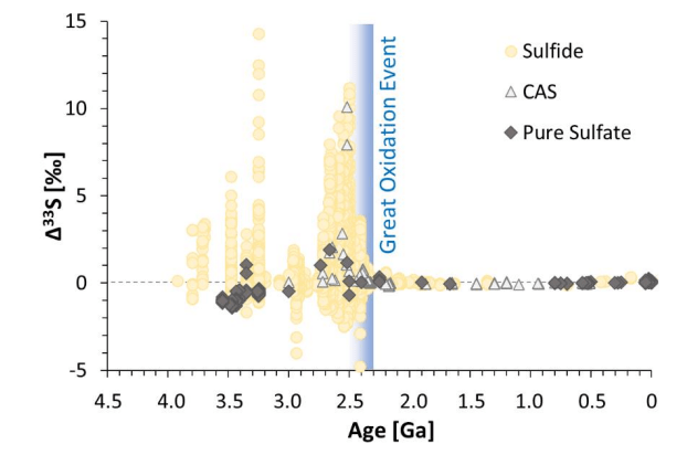
Earth’s history involves many chemical reactions. The research document displays data on sulphur isotope fractionation in sediments. The presence of sulphur changed after the Great Oxygenation Event (GOE). This happened because oxygen in the air created an ozone layer. This layer blocked UV radiation. As a result, the breakdown of sulphur dioxide by UV light stopped. The researchers state, “Anoxic planets, which do not produce O2, are similar to the early Earth before the GOE.” Image Credit: Stüeken et al. 2024.

As humanity ventures into the unknown regions of space, Earth remains our guiding beacon. Through thorough study and technological innovation, we inch closer to unlocking the secrets of the cosmos. Each discovery brings us closer to answering one of the most profound questions: Are we alone in the universe?

Hashtags:

#Exoplanets, #Astrobiology, #Biogeochemistry, #SpaceExploration

Five New Hydrothermal Vents Found in the Pacific Ocean

Key Takeaway

The exploration of the eastern Tropical Pacific Ocean has led to the remarkable discovery of five new hydrothermal vents at a depth of 2,550 meters, furthering our understanding of these geological phenomena and their role in sustaining unique ecosystems.

Summary

  • Five new hydrothermal vents were discovered in the eastern Tropical Pacific Ocean at a depth of 2,550 meters (approximately 1.6 miles) along the East Pacific Rise near 10°N latitude.
  • The discovery was made through a collaborative effort between the autonomous underwater vehicle Sentry and the manned submersible Alvin, combining advanced mapping capabilities and direct observational power.
  • Hydrothermal vents are hotspots of geothermal activity formed by the divergence of two tectonic plates, with the East Pacific Rise being a major volcanic mountain chain where plates are splitting apart at a rate of about 11 centimeters (4.3 inches) per year.
  • Hydrothermal vents support unique ecosystems that thrive in high-pressure and high-temperature environments, providing insights into biological resilience and life’s sustainability under extreme conditions.
  • The mid-ocean ridge accounts for more than 75% of all volcanic activity on our planet and is dotted with thousands of deep-sea hot springs that release a significant portion of the Earth’s internal heat.
  • Studying hydrothermal vents enhances our understanding of how they release heat and chemicals, affecting the global ocean.
  • Future expeditions will leverage advanced technology to further study the geophysical, chemical, and biological processes shaping our planet.
  • The discoveries of hydrothermal vents add pieces to the puzzle of our planet’s complex ecosystem, reshaping our understanding of the fabric of life and the Earth.
  • The researchers plan to continue studying hydrothermal activity and volcanism along the East Pacific Rise in follow-up expeditions, uncovering more mysteries hidden in the depths of the ocean.

Five New Hydrothermal Vents Found in the Pacific Ocean


Five New Hydrothermal Vents Discovered

In the eastern Tropical Pacific Ocean, an exciting discovery has been made. Five new hydrothermal vents have been found. They are located at a remarkable depth of 2,550 meters, or about 1.6 miles below the surface. This discovery broadens our understanding of geological phenomena. It also provides insights into the complex ecosystems found in these extreme environments.

The exploration combined the efforts of the autonomous underwater vehicle Sentry and the manned submersible Alvin. These technologies helped reveal deep sea secrets. Sentry used its high-resolution mapping capabilities to gather essential data. This data helped in planning Alvin’s future dives. Consequently, the team was able to observe and study hydrothermal vents up close.

The discovery site is located along the East Pacific Rise near 10°N latitude. It is on a large volcanic mountain chain. This chain is created by the movement apart of two tectonic plates. This area is very active geologically. Here, the plates are pulling apart at a rate of about 11 centimeters (4.3 inches) per year.

Hydrothermal vents are truly remarkable features, serving as hotspots of geothermal activity where superheated water and minerals gush out from the seafloor. These vents are not only geological wonders but also support unique ecosystems that thrive in the high-pressure and high-temperature environments.

Jill McDermott, director of the Lehigh Oceans Research Center, emphasized the synergy between Sentry’s mapping capabilities and Alvin’s direct observational power, stating, “The high-resolution maps from Sentry allow us to spot likely new hydrothermal fields soon after Sentry comes back on deck. This gives us great targets for Alvin and the opportunity to make multiple discoveries in a single dive.”

The study of hydrothermal vents holds immense significance for our understanding of life’s resilience and adaptability. These extreme environments have given rise to specialized organisms that have evolved to thrive in conditions that would be harsh to most other forms of life.

Scientists study the unique ecosystems around hydrothermal vents to learn about the origins and evolution of life on Earth. This research also helps them understand the possibility of life on other celestial bodies with similar conditions.

Five New Hydrothermal Vents Found in the Pacific Ocean

Beyond their biological significance, hydrothermal vents also provide a window into the Earth’s internal processes. Thibaut Barreyre, an expert in thermal measurements, highlighted the role of the mid-ocean ridge, stating,

“The mid-ocean ridge accounts for more than 75% of all volcanic activity on our planet. It is dotted with thousands of deep-sea hot springs which collectively release a significant portion of the Earth’s internal heat.”

Scientists study the heat and chemicals released from hydrothermal vents. This research helps them understand the Earth’s mantle. It also reveals the processes that shape our planet’s landscape and global ocean systems.

The recent discoveries along the East Pacific Rise are just the beginning of a new chapter in our exploration of the deep sea. The researchers, including marine geologist Daniel Fornari, plan to continue studying hydrothermal activity and volcanism in this region through follow-up expeditions.

Marine geophysicist Ross Parnell-Turner and his team are using the latest technology to map the ocean floor in detail. They aim to uncover secrets hidden in the depths. Each new discovery broadens our understanding of Earth’s complex ecosystem. This reshapes how we see life on our planet.

HASHTAGS:

#hydrothermalvents, #oceanexploration, #deepseadiscovery, #marineecosystems, #extremeenvironments, #geothermalactivity, #tectonicplates, #oceanography, #underwaterresearch, #advancedtechnology #Hydrothermal Vents

China Releases High-Resolution Moon Atlas

Key Takeaway

China has released a comprehensive and high-resolution geological atlas of the Moon, providing detailed data on craters, basins, lithologies, and structures, which will be invaluable for future lunar exploration missions and scientific research.

Summary

  • The Chinese Academy of Sciences (CAS) has released the first complete high-definition geologic atlas of the Moon, providing basic geographical data for future lunar research and exploration.
  • The atlas includes data on 12,341 craters, 81 impact basins, 17 types of lithologies, 14 types of structures, and other geological information about the lunar surface.
  • It was compiled by a team of over 100 scientists and cartographers from relevant research institutions, led by Ouyang Ziyuan and Liu Jianzhong from the CAS.
  • The team spent more than a decade compiling scientific exploration data obtained by the Chinese Lunar Exploration Program (Chang’e) and other research on the origin and evolution of the Moon.
  • The atlas includes an “upgraded lunar geological time scale” for depicting the geological evolution of the Moon, including lunar tectonics and volcanic activity.
  • It could improve the understanding of the formation and evolution of Earth and other terrestrial planets in the Solar System.
  • The atlas doubles the resolution of the Apollo-era maps compiled by the US Geological Survey in the 1960s and 70s.
  • It is expected to aid in site selection for China’s International Lunar Research Station (ILRS) and NASA’s Artemis Base Camp, as well as future sample collection missions like Chang’e-6 and Chang’e-7.
  • The CAS also released a book called “Map Quadrangles of the Geologic Atlas of the Moon,” which includes 30 sector diagrams forming a visualization of the entire lunar surface.
  • Both the atlas and the book are available in Chinese and English and have been integrated into a digital platform called “Digital Moon,” eventually becoming available to the international research community.
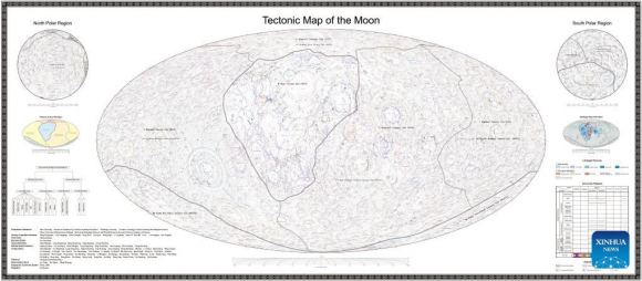
China Releases High-Resolution Moon Atlas
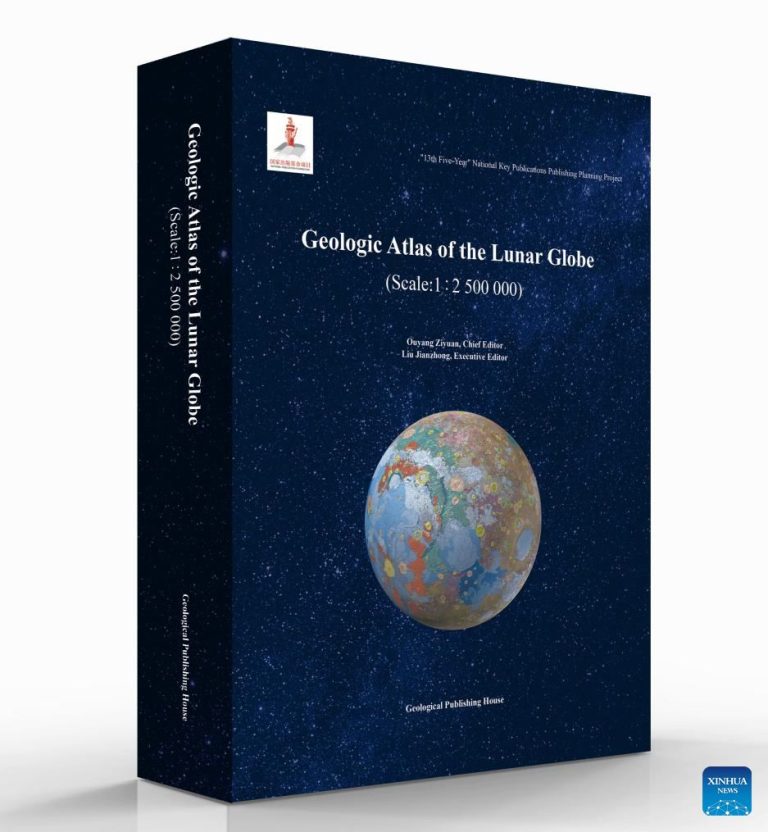
Credit: This image was provided by the Chinese Academy of Sciences via a Xinhua news release.

China’s High-Resolution Geological Atlas

As humanity sets its sights on returning to the Moon and establishing a long-term presence, the need for comprehensive and accurate lunar data has never been more pressing. In a monumental achievement, the Chinese Academy of Sciences (CAS) has unveiled the first complete high-definition geological atlas of the Moon, marking a significant milestone in our quest to unravel the mysteries of our nearest celestial neighbor.

This atlas is the result of over ten years of hard work by more than 100 scientists and cartographers. It will be very useful for future missions to explore the Moon and for scientific studies. The atlas includes data from China’s Chang’e lunar exploration program and other advanced research. It provides a detailed and insightful look at the Moon’s geology.

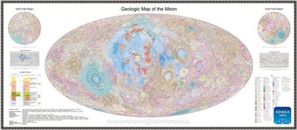
This groundbreaking atlas contains detailed information about the lunar surface. It includes data on 12,341 craters, 81 impact basins, and 17 different rock types. Additionally, there are 14 distinct structural features recorded. This extensive database offers a detailed look at the Moon’s current state. It also provides insights into the Moon’s formation and evolution.

The atlas features an “upgraded lunar geological time scale.” This scale provides a detailed look at the Moon’s geological history. It covers tectonic activity and volcanic processes that shaped the Moon’s surface. This new approach aims to enhance our understanding of the Moon’s development. It also seeks to illuminate the evolutionary processes of Earth and other terrestrial planets in our Solar System.

China Releases High-Resolution Moon Atlas
Credit: This image was provided by the Chinese Academy of Sciences via a Xinhua news release.

Notably, the new atlas boasts a resolution that doubles that of the Apollo-era maps created by the US Geological Survey in the 1960s and 70s. This significant improvement in precision and detail is a testament to the remarkable advancements in lunar exploration and scientific research over the past decades.

The release of this atlas couldn’t have come at a more opportune time, as multiple space agencies, including China and NASA, are gearing up to establish long-term lunar outposts in the coming years. The detailed information provided by the atlas will prove invaluable in selecting optimal sites for endeavors such as China’s International Lunar Research Station (ILRS) and NASA’s Artemis Base Camp.

Moreover, the atlas is expected to play a crucial role in guiding future lunar sample collection missions, such as Chang’e-6 and Chang’e-7, which aim to retrieve lunar soil, rock, and ice samples from the Moon’s surface.

While the atlas represents a remarkable achievement for China’s lunar exploration program, its significance extends far beyond national boundaries. As Gregory Michael, a senior scientist from the Free University of Berlin, appropriately stated,

“This map, in particular, is the first on a global scale to utilize all of the post-Apollo era data. It builds on the achievements of the international community over the last decades, as well as on China’s own highly successful Chang’e program.”

In addition to the Geologic Atlas of the Lunar Globe, the CAS has also released a complementary book titled “Map Quadrangles of the Geologic Atlas of the Moon,” which features 30 sector diagrams that collectively form a comprehensive visualization of the entire lunar surface.

China Releases High-Resolution Moon Atlas
Credit: This image was provided by the Chinese Academy of Sciences via a Xinhua news release.

Both the atlas and the book are available in Chinese and English and have been integrated into a digital platform called “Digital Moon,” ensuring their accessibility to the international research community.

HASHTAGS:

#LunarExploration, #GeologicalAtlas, #ChineseAcademyOfSciences, #ChangEProgram, #MoonMapping, #LunarScience, #SpaceExploration, #LunarResources, #MoonMysteries, #InternationalCollaboration #High-Resolution Moon Atlas

Further Reading: The Chinese Academy of Sciences (CAS)

How Small Aerosols Shape Cloud Formation

Key Takeaway

The study reveals that aerosols as small as 25-30 nanometers, much smaller than previously thought, can initiate cloud formation, which challenges current climate models and suggests the need for recalibration to account for the influence of these tiny aerosols on cloud formation and climate predictions.

Summary

  • A recent collaborative study utilizing global satellite data and direct observations off the California coast shows that aerosol particles as small as 25-30 nanometers are crucial for cloud development, contrary to the established norm of 60 nanometers.
  • Clouds are essential components of Earth’s climate system, but they also constitute one of the largest uncertainties in understanding climate change.
  • The study focused on the behavior of cloud condensation nuclei within marine stratus clouds and found that the size threshold required for these nuclei to trigger cloud formation is much smaller than previously believed.
  • Traditionally, it was thought that cloud condensation nuclei had to be relatively large, but the researchers discovered that even smaller proto-seeds can serve as effective nuclei.
  • The sensitivity of cloud formation to these smaller aerosols arises because they can be activated into cloud droplets in conditions where water is highly supersaturated.
  • The combined observations from marine stratus clouds and global data from the MODIS satellite instrument revealed a consistent pattern of higher-than-expected supersaturation across the globe, adjusting the scale of critical seed size downwards.
  • The discovery that smaller aerosols can effectively contribute to cloud formation suggests that climate models need to be recalibrated to account for these dynamics, potentially improving predictions of future climate scenarios.
  • The study not only challenges established paradigms in climatology but also opens the door for further investigations into the delicate interplays at the heart of our planet’s climate system.

Tiny Aerosols: The Unexpected Key Players in Cloud Formation

Cloud formation is a complicated process that has always interested scientists and climatologists. Clouds are crucial to our atmosphere. They help regulate Earth’s climate by reflecting sunlight and interacting with thermal radiation. A recent groundbreaking study has challenged our understanding of how clouds form.

Traditionally, it was believed that cloud condensation nuclei – the seed particles around which water condenses to form clouds – had to be relatively large, typically around 60 nanometers or larger. This belief was deeply ingrained in climate models and our understanding of atmospheric processes.

However, a collaborative research effort involving scientists from The Technical University of Denmark, the University of Copenhagen, and the Hebrew University of Jerusalem has uncovered a surprising truth that could redefine our approach to climate modeling.

Through a combination of global satellite data and direct observations off the California coast, the researchers made a remarkable discovery: aerosol particles as small as 25-30 nanometers can initiate cloud formation. This finding challenges the long-held assumption that larger particles are necessary for this process.

The study focused specifically on the behavior of cloud condensation nuclei within marine stratus clouds, which are prevalent over vast swaths of the Earth’s oceans. The researchers found that the size threshold required for these nuclei to trigger cloud formation is much smaller than previously believed.

The sensitivity of cloud formation to these smaller aerosols arises from a fundamental principle: the denser the water vapor, the smaller the necessary seed particle. In other words, in conditions where water is highly supersaturated, even minuscule aerosol particles can catalyze the formation of cloud droplets.

This revelation deeply affects our understanding of climate dynamics. It also impacts the accuracy of climate models.

The study’s findings suggest that current climate models may be underestimating the influence of smaller aerosols on cloud formation, particularly in pristine areas where marine stratus clouds dominate. As a result, these models may need to be recalibrated to account for the dynamics of these tiny particles.

Henrik Svensmark, the lead author of the study, emphasized the significance of this discovery:

“Current models show that due to the growth time, most of the small aerosols are lost before they grow to the critical size, and thus, cloud formation is rather insensitive to changes in the production of small aerosols. Our results change this understanding as aerosols must grow much less, which is important for modeling clouds and climate predictions.”

This study challenges existing ideas in climatology and encourages more research into our planet’s climate system. It focuses on the complex interactions involving aerosols, water vapor, and clouds. Exploring this balance is crucial because it deeply affects our understanding of climate change and its consequences.

HASHTAGS:

#climatechange, #cloudformation, #aerosols, #climatemodeling, #atmosphericscience, #environmentalresearch, #sustainability, #climateaction, #scientificdiscovery, #globalwarming

Source: Geophysical Research Letters

Why Is the North Pole Warming Faster Than Any Other Region?

Key Takeaway

The North Pole is warming at an alarmingly rapid pace compared to the rest of the planet due to the combined effects of lingering ozone and the influx of warm air masses from lower latitudes.

Summary

  • The Arctic is experiencing intense warming several times faster than the global average, signaling major disruptions in both the Arctic and global climate systems.
  • Dr. Barten’s research at Wageningen University reveals two key factors driving the accelerated warming at the North Pole:
    • Ozone, a potent greenhouse gas, is lingering longer in the Arctic atmosphere than previously assumed, amplifying its warming effect.
    • Warm air masses from lower latitudes are increasingly intruding into the Arctic region, transporting additional ozone and directly contributing heat.
  • Soot particles from fossil fuel combustion, when deposited on Arctic snow and ice, absorb solar radiation and accelerate melting.
  • The melting of Arctic ice has falling effects beyond the polar regions, including rising sea levels, more intense storms, prolonged droughts, and heatwaves.
  • Transitioning away from fossil fuel dependence, prioritizing clean energy sources, and promoting sustainable practices are crucial steps to slow Arctic warming.
  • Raising awareness and demanding bolder climate action from leaders and businesses are essential to address the urgency of the situation.

Why Is the North Pole Warming Faster Than Any Other Region

Insights into a Warming World

The Arctic is facing a quiet crisis. It threatens our planet’s climate balance. The North Pole used to be covered in pure ice and snow. Now, it is the center of a worrying change. Temperatures are rising quickly, faster than ever before. Scientists are urgently trying to figure out what is causing this swift increase in warmth.

The Arctic’s warming is not just a local problem; it signals worldwide climate change. Studies show that the Arctic is warming much faster than the rest of the world. This rapid warming raises the alarm for significant disruptions in the Arctic and the global systems it affects.

Dr. Barten from Wageningen University has identified two main causes of the North Pole’s rapid warming: ozone and warm air intrusions.

Ozone is usually known for protecting us from the sun’s harmful rays high in the atmosphere. However, it also acts as a powerful greenhouse gas near the Earth’s surface. In the Arctic, certain atmospheric conditions cause ozone to stay longer, increasing its warming effect.

Dr. Barten notes, “In the Arctic, ozone is absorbed by seawater, snow, and ice, but this happens slower than we thought. This slow absorption keeps more ozone in the air, warming the region.”

Traditionally stable, cold Arctic air is now frequently disrupted by warmer air from the south. These warmer air spells, driven by broader climate change, are more common and severe. They not only bring more ozone to the Arctic but also melt ice faster, strengthening the warming cycle.

The idea of the Arctic as a remote, untouched wilderness is quickly disappearing. Industrial activities produce soot, a byproduct of burning fossil fuels, which travels long distances and settles on Arctic ice and snow.

Soot, unlike reflective white snow and ice, absorbs solar energy. This absorption speeds up the melting of the Arctic ice, leading to higher sea levels and disrupted ecosystems.

Ignoring the melting Arctic as a distant issue is misleading. The Arctic is vital to the Earth’s climate system, with its changes affecting the entire planet.

Melting Arctic ice directly raises ocean levels, threatening global coastal areas with more floods and displacing millions. The Arctic also shapes global weather patterns by influencing major air and water currents that distribute heat and moisture worldwide.

As the Arctic’s systems are thrown off, we experience effects like:

  • More intense storms in regions accustomed to mild climates
  • Prolonged droughts that decimate crops and threaten food supplies
  • Heatwaves and temperature swings that push infrastructure (and human bodies) to their limits

The situation is urgent but not hopeless. We have powerful tools to slow and potentially limit the Arctic’s transformation. Our choices and policy support can directly affect how quickly and extensively the area warms.

The main cause of global warming, including changes in the Arctic, is our reliance on fossil fuels. To combat this, we must prioritize clean, renewable energy, invest in energy efficiency, and quickly reduce our dependence on fossil fuels.

Even small actions can make a big difference when millions of people participate. Simple steps like conserving energy at home, using public transit or biking, and demanding environmentally responsible practices from businesses are important.

The trouble of the Arctic must be a key topic in climate discussions. We need to voice our concerns to leaders, representatives, and businesses, urging them to take bold climate action. Policies need to match the urgency of the situation.

The transformation of the Arctic is a clear indicator of how connected our planet’s systems are and the extensive impacts of our actions. By understanding what drives the rapid warming at the North Pole, we can aim for a sustainable future. This future would preserve the Arctic’s beauty and maintain the balance of our global climate.

HASHTAGS:

#ArcticWarming, #ClimateChange, #NorthPole, #Ozone, #WarmAirIntrusions, #Soot, #RisingSeaLevels, #ExtremWeather, #FossilFuels, #RenewableEnergy, #Sustainability, #ClimateAction #North Pole

Read the entire study here

Pin It
error: Content is protected !!

This website utilizes first- and third-party tools that store small files (cookies) on your device. These cookies serve various purposes, including ensuring the site functions correctly (technical cookies), analyzing site usage (analytics cookies), and delivering relevant advertisements (profiling cookies). While technical cookies are essential and used by default, you have the option to enable or disable analytics and profiling cookies. By allowing these cookies, you help us enhance your browsing experience.